|
 |
|
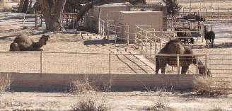
Camels & Llamas
Along Bosque Trail
|
The Paseo del Bosque
Bike Trail, also called the Riverside Bike Path in places, is a
lovely 16 mile-long paved bikepath, uninterrupted by roadways. The
trail parallels the Rio Grande bosque on the east side of the Rio
Grande from Alameda Blvd. in the north to where it intersects 2nd
Street on the south. There are no street crossings for the 16 miles.
The Bernalillo County Chris
Chavez Bikepath continues east crossing
under 2nd
street. The Bosque Bikepath follows the languid Rio Grande through the
cottonwood bosque, past Tingley Beach and the Nature Center under all
the busy highways. Since the bikepath parallels the diversion channel
it is a flat as they get. Along the bikepath, aside from the exotic
camels, lamas, ostriches (no joke) you can see road runners, coyotes,
and migrating ducks, cranes, ospreys, and geese. Keep you eye out for
migrating bald eagles along the river or elephants at the zoo. In
the fall the
bikepath is covered with cottonwood leaves. The bike path passes the Rio
Grande Zoo, the Rio Grande Nature Center State Park,
and
the
Rio Grande Botanical Garden.
 The
bikepath
is used by children, recreational road cyclists, and experts
(usually getting from one side of the city to another), not to mention
walkers, inline skaters, joggers, and others. A gravel parallel road
parallels the paved path on the northern portion. Be careful not to
startle horses. The
bikepath
is used by children, recreational road cyclists, and experts
(usually getting from one side of the city to another), not to mention
walkers, inline skaters, joggers, and others. A gravel parallel road
parallels the paved path on the northern portion. Be careful not to
startle horses.
There
is no water or bathrooms on the trail. There are porta-potties at
the Alameda trailhead and bathrooms at Tingley Beach. It crosses the
diversion channel over several
well maintained bridges and there are little benches along the way. The
only negative is that there are several chicanes, or "mazes" south of
Tingley beach where you have to dismount and walk your bike through.
The are connections at Rio Bravo where you can find a convenience store
nearby if you're getting hungry.
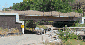
The bikepath also crosses under several highways that can be icy in the
winter so be careful in the shaded areas. This is especially true for
I-40 and Montaño. The wooden bridges may be icy in the early
cold mornings.
This is a very popular route with walkers and
joggers so start early on weekends. This is a great place to ride in
the cold winter months. A number of NMTS rides use the Bosque Bikepath
as a portion of the ride, see the La
Llorona Ride. This is also a good route to cross the
city in the N-S direction, avoiding traffic.
Distance: The
Bosque/Riverside Bike Trail total length is about 16 miles each way.
Elevation gain: 45' north to south, 125' south to north, nearly dead
flat.
Roadway: Nice
pavement and a couple of wooden bridges that cross diversion channels.
Lots of foot traffic, kids, especially inline skaters. Be careful of
the descent under the Montaño and Paseo del Norte bridges due to
unexpected pedestrian or horse traffic. There is often ice under these
and the I-40 bridge in the winter.
|
 |
|
Montgomery Underpass
- Watch Your Speed
|
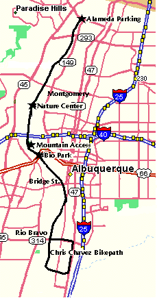
Getting There:
The Bosque Bike Trail crosses under all the major highways so there are
numerous places to start. The following are some of the places to park.
- Alameda Blvd. Open Space Parking Lot - Alameda Blvd. & the river. This is the north end so you
can ride south 16 miles and back. There is a dirt lot just east
of the river. Also there is a picnic area on Rio Grande Blvd to the
east. Porta-potties.
- Bio Park -
Central Avenue and the river. This has a large parking lot and the
trail is on the west side of the Bio Park next to the train station.
There is a small parking lot right at the stop light.
- Nature Center
- End of Candelaria - The Nature Center has a lot of neat paths that
you can walk and intersects the bikepath. There is a short paved
bikepath/sidewalk on the west side of the bikepath. You have to
walk your bike through the Nature Center.
- Mountain -
There is a popular entrance at the west end of Mountain Blvd., west of
Old Town. Park in Old Town, ride west on Mountain, cross Rio
Grande Blvd. to where Mountain dead-ends at the gate to the short paved
access trail to the Bosque Trail.
- Duranes & Gabaldon Dr. SW - West of the 4-way stop on Duranes is an entrance, no
parking.
- Campbell Rd.
NW - Ends at the bikepath. No parking.
- Rio Bravo 2nd St., & Bridge - Take Rio Bravo
west from 2nd St., north on Poco Loco just before the Rio Grande
bridge. The Rio Bravo Riverside Picnic Area has limited parking.
- Montano - Parking at the Pueblo Montano Picnic
Area east of Coors.
- Marquez - Open space parking west of Tingley. Nice
new acess.
- Paso del Norte - There is a parking lot at the sw
corner of El Pueblo and Rio Grande.
- Chris Chavez bikepath - At 2nd St. in the south the bikepath continues as the
county's Chris Chavez bikepath. This continues east, then follows the
diversion channel north to Rio Bravo. From there retrace your path,
turn left (west) on the Rio Bravo bikepath back to the Bikepath or ride
east on Rio Bravo with no bikepath.
Options:
- There is a nice off-road single track
out-and-back on the north side of Alameda Blvd. on the west side of the
river that winds through the bosque north almost to Corrales. There is
a parking lot there on the north west. From the Alameda Open Space
Parking lot go under Alameda, up the hill cross the old bridge to the
west side, then on the levee for a short distance and drop down on the
first single track on the right.
- Forget the levee on the north east side.
It looks inviting but it is sandy, it is goathead heaven, and it stops
abruptly at the "No Trespassing" signs at the Indian reservation.
- The Chris Chavez
Bikepath continues from the south end of the
Bosque Bikepath at the South Diversion Channel and 2nd Street along the
diversion channel to Rio Bravo where it turns west (left) and follows
Rio Bravo back to the Bosque Bikepath.
- Connecting rides include City
Circle, Double Eagle, East Albuquerque Perimeter, Fast50, La Llorona,
Los Luna Spin, NorthEast Loop, and the Tour de Chavez.
- Connection to the nice new Matthew bikepath from the
narrow exit about .3 miles S of Campbell near I-40 via Don Quixote Dr
across Rio Grande Blvd.
Notes:
- City of Albuquerque Paseo del Bosque Bike Trail webpage.
Trail
Map.
- There are porta-potties at the Alameda
trailhead and bathrooms at Tingley Beach. There is one break in
the fence behind Tingley that you can use.
- Be prepared for flats on the bikepath.
There are lots of "goat-heads" along the way in season.
- Weather at Alameda and the Rio Grande.
- The bikepath also crosses under several
highways that can be icy in the winter so be careful in the shaded
areas. This is especially true for I-40 and Montano. Also watch for ice
on the wooden bridges.
- Be especially alert at the Montano and
Paseo del Norte underpasses. There is limited line of sight and there
is often pedestrians or horses standing in the middle of the trail when
you come roaring down the trail.
- City of Albuquerque Paseo del Bosque Bike Trail web page and map - Describes the trail, access locations,
etc.
- Rio Grande Nature Center State Park
- Rio Grande Zoo
- Rio Grande Botanical Park
- Albuquerque BioPark
|