| Mileage |
Waypoint |
Leg Description |
|
0
|
UNM observatory parking lot. |
Ride east on Tucker two blocks to Stanford. |
|
.2
|
Stanford |
Turn left (north) on Stanford for 2 blocks to Constitution. |
|
.4
|
Constitution |
Turn right (east) on Constitution to Indian School (cross I-40 at Pennsylvania). |
|
7.65
|
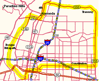
Indian School (near Tramway) |
Turn right (east) to Tramway Blvd. Cross Tramway Blvd. on the overpass. |
|
7.8
|
Tramway Blvd |
Turn left (north) along Tramway Blvd., then east passing under I-25 to Second Street. This is a
great downhill stretch on the west bound section. Tramway is open and has good shoulders the whole way.
Be careful passing in front of the Sandia Casino, don't get run over by a drunk gambler turning right into the
Sandia Casino. |
|
21.3
|
Second Street |
Turn left (south) on Second Street, watch traffic here, to Ortega. |
|
23.4
|
Ortega |
Turn right, on Ortega west to Rio Grande. |
|
24.7
|
Rio Grande |
South on Rio Grande to Paseo del Nordeste bike trail just south of Paseo del Norte overepass. |
|
25
|
Paseo Bikepath |
Turn right (west) on the Paseo bike path to the Riverside bikepath. |
|
25.25
|
Riverside (Bosque) Bikepath |
Turn left (south) along the Riverside bike trail to Marquez, south of the zoo. |
|
34.25
|
Marquez |
Turn left onto Marquez for 2 blocks to Barelas. |
|
34.5
|
Barelas |
Left on Barelas (north) to Cromwell, the first right. to Take Barelas downtown and MLK Blvd. to
UNM. |
|
34.6
|
Cromwell |
Right (east) on Cromwell three blocks to 2nd Street. This has some traffic. |
|
34.8
|
2nd Street |
Turn left (north) on 2nd Street downtown to Martin Luther King. 2nd Street has moderate traffic.
MLK west is one way west so this is the west most point to intersect. |
|
35.9
|
MLK |
Turn right (east) on MLK, pass under I-25, climb, take the 1st or 2nd left past I-25 (depending
on traffic), this is Mulberry or Cedar. There may be west bound cars stopped at I-25 with all the construction
going on. |
|
36.7
|
Mulberry or Cedar |
Turn left (north) one block to Roma. |
|
36.7
|
Roma |
Right (east) on Roma, cross University to Yale. |
|
37.4
|
Yale |
Turn left (north) on Yale, cross Lomas, climb the hill to the UNM Observatory. |
|
37.8
|
UNM Observatory |
|