Turn
Mileage |
Leg
Mileage |
Leg Description |
|
0
|
0
|
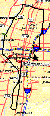
UNM Observatory parking lot - Ride south to Lomas at the traffic light. |
|
.15
|
.15
|
Lomas - Turn right, Ride to 3rd St. |
|
1.8
|
1.8
|
3rd St. - Turn left (S). Ride past Rio Bravo |
|
3.25
|
Jog Left to 2nd St. at Caesar Chavez - Continue South |
|
6.4
|
Cross Rio Bravo - Continue South |
|
8.1
|
8.1
|
South Diversion Channel - Turn Right (W). Curves North - Becomes Riverside
Trail and follows diversion channel on the right (east). |
|
10.2
|
Cross under Rio Bravo - Continue North - Pass Tingely Beach |
|
13.4
|
Jog left the right under Bridge - Continue North |
|
15.4
|
Cross under Central (watch your head) - Pass Bio Park - Continue North |
|
16.4
|
Pass Mountain Rd. Exit on the right - Continue North |
|
16.75
|
I-40 Underpass - Continue North |
|
17.9
|
Cross bridge to left (west) of channel - Continue North |
|
18.5
|
Nature Center - Continue North - Watch for pedestrians crossing |
|
19.6
|
Montano Underpass - Continue North |
|
22.75
|
22.75
|
Paseo del Norte - Turn Right (E) on Paseo Bikepath. Stay up to the left,
don't go unter Paseo.
Cross Rio Grande and under 4th street. |
|
24.3
|
Second St. - Jog right (S) one block to El Pueblo, turn left (east). Follow
bikepath after Edith. |
|
25.0
|
Edit - Cross to the bikepath on the far left - continue on the Paseo bikepath. |
|
25.4
|
25.4
|
N. Diversion Channel - Turn Right (South) - Follow all the way to UNM. |
|
27.0
|
Jog right to cross Osuna at the traffic light, jog left back to the bikepath
- continue south. |
|
27.1
|
Bikepath junction - Keep right (south) |
|
28.1
|
Stay right, cross the bikepath bridge, go under I-25 - Continue south. |
|
28.9
|
Cross Bridge, stay right at the bikepath junction - continue south. |
|
30.5
|
I-40 Underpass - Curve right (W), Cross Indian School, continue south. |
|
32
|
32.0
|
Jog left (east) on Tucker with the Observatory in sight. |
|
32.2
|
32.2
|
UNM Observatory |