Los Lunas Spin
The long-time popular Los Lunas Spin loop begins and ends at the Albuquerque Bio Park parking lot near central.The ride is fairly flat and rapid. The route goes through the picturesque south valley and south into the Rio Communities of Los Lunas and Valencia. The traffic is not bad and there are shoulders along much of the way.
This ride can be combined with other rides to make a long tour.
Distance: 50 Miles out and back, fairly flat.Getting There: A favorite is the Albuquerque Bio Park overflow parking lot on Central Ave. at the Bosque Trail. There are a number of optional starting locations.
Roads: All paved. NM47 and 2nd Street have light traffic on mornings. There is a bit more traffic once you get south to Bosque Farms and on into Los Lunas. There are shoulders on NM47 mostly until you get into Los Lunas and Isleta Blvd. on the return. Rio Bravo can be busy but it's short.
Notes:
- See the Bosque Trail for its description.
- Chocolates, Etc. is a favorite stop.
3414 Hwy 47
Los Lunas, NM 87031-8283
(505) 865-1004Options:
- Beginning at an alternate starting location at Indian School, ride south on the surprising pleasant Williams, to Woodward to 2nd St. to Desert to Bates to NM47 then south to Los Lunas.
- Combine this with a loop out to the Double Eagle Airport and Paradise Hills for a century ride. When returning north, turn left at Rio Bravo instead of right and ride to 9-Mile Hill and onto Double Eagle airport, then onto Paradise Hills and back down to the Bosque Bikepath.
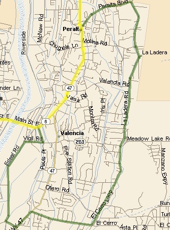
- The La Ladera Loop avoids the NM47 and NM6 intersection, which isn't that bad and adds a few miles riding around Peralta and Valencia shown in green on the map.
- There is also the shorter, picturesque Bosque Loop shown in green on the map.
- See the Tour de Valencia for more options. These tours are at the south of this tour. The Manzano "expressway" in particular is a surprisingly great ride east of Valencia and is just east at the south end of the La Ladera loop.
Route Map
Los Lunas Spin Cuesheet // 50 Miles
Mileage Waypoint Leg Description 0
Abq Bio Park Take the Bosque Trail south to the junction with 2nd Street. 7.25
2nd Street Turn left, take 2nd Street South 8
Desert
(NM303)Turn left (east) on Desert (NM303) 8.05
Bates Almost immediately, turn right (south) on Bates. 8.25
Atchinson Turn left (east) onto Atchinson. which curves south to ... 9.3
Coso Turn left (east) onto Coso 9.6
NM47 Turn right (south) onto NM47 towards Los Lunas (shoulders). cross over the interstate, one of 2 hills, ride into Bosque Farms, where the road narrows and traffic picks up, and into Los Lunas. You pass a couple of convenience stores. A stop at Chocolates, etc. is fun if it is open. 21.8
NM6 Turn right (west) on NM6 (Main St.) there's more slow traffic here but not usually a problem. NM6 curves west and crosses the Rio Grande. 23.4
Los Lentes Turn right (north) on Los Lentes. 25.6
Griego Turn left (east) on Griego for a short jog to US85 (NM314 - Isleta Blvd.) 25.9
NM85 Turn right (north) on NM85 towards Albuquerque. Usually moderate traffic with some shoulders. Cross over I-40 again (one small hill). You pass a number of convenience stores. 39.8
Rio Bravo Turn right (east) on Rio Bravo (NM500) - a major street with a turn signal. Cross the Rio Grande 40.5
Poco Loco Just past the river, and pass over the bikepath and the diversion channel, turn right on Poco Loco, make a U-turn and ride west to the Bosque Bikepath. 40.6
Bosque Bikepath Turn right (north) and ride back to the Bio Park. 45
Central Ave. Abq Bio Park parking lot.
La Ladera Loop (Option)
Mileage Waypoint Leg Description 0
NM47 at Peralta Take Peralta (intersection is 0.4 miles South of Bosque Loop South) left (east) to La Ladera. 1.4
La Ladera Turn right (south) on La Ladera. Continue south on La Ladera, pass MeadowLake (Hwy 263). It turns into Cerro Loop. 7
El Cerro Loop Turn (curve) right (west) on El Cerro Loop to NM47. 8.5
NM47 Turn left (south!!) on NM47. 9
Edeal Turn right (west) on Edeal 9.3
Edeal Turn (curve) right (north) on Edeal. 11.3
Sun Valley Rd Turn right (east!!) onto Sun Valley Rd. 11.7
Hwy263 Turn left (north) on Hwy263 (el Cerro Rd). 12.1
NM6 Turn left (west) on NM6. Rejoin main route. Ride to Los Lentes. Rd. 13.2
Los Lentes Rd Turn right (north) on Los Lentes Rd. Rejoin main route north.
La Ladera Loop Option (Green)
Bosque Loop (Option)
Mileage Waypoint Leg Description 0
(17.75)N Bosque Loop Turn right (west) on North Bosque Loop in Bosque Farms that is at about the 17.75 miles point on the main route, 8.15 miles south of Coso. .8
W Bosque Loop Turn left (south) on West Bosque Loop. 2.1
S Bosque Loop Turn (left) (east) on South Bosque Loop. 2.9
NM47 Turn right (south) on NM47. Back on the main route.