| Mileage |
Description |
|
0
|
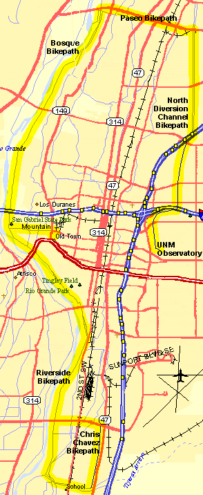
UNM Observatory. Ride west on Tucker (north of the parking lot) down the
hill, turn right (north) on the bike path.
Cross Indian School. On the North Diversion Channel Bikepath cross Menaul, Candelaria, Comanche, Montgomery, and
Osuna. Watch traffic when crossing these streets. |
|
7
|
Cross railroad tracks. Turn left (west) onto the Paseo del Norte Bikepath. |
|
10
|
Turn left (south) on the Bosque Bikepath after the horse corrals. Do not cross the river! |
|
13
|
Continue south under Montaño. Limited visibility - watch for pedestrians.
Watch for ice in the winter. |
|
16
|
Continue south under I-40. Watch for ice and pedestrians. Sharp turns on
the south side. Continue south at the turn to Mountain. |
|
18
|
Continuing south, . The bikepath ride along the west side of the BioPark
climbs to the entrance to a parking area before descending under Central Avenue. This is often a good place to
take a break and regroup. Continue south under Central. |
|
20
|
Continue south under Bridge Blvd. |
|
23
|
Continue south under Rio Bravo Blvd. |
|
|
The bikepath continues south, crosses another bridge over a channel, climbs
on top a levee then curves left (east) along a diversion channel. Continue east along the bikepath as it crosses
under 2nd St. (watch for gravel from the above railroad tracks). This is now the Chris
Chavez Loop. Cross another bridge over the channel (watch the
sharp turns) then curve left (north) still along the diversion channel. (Tour de Junkyard). Ride north along the
bikepath crossing several streets - watch for cars to Rio Bravo.
Turn left (west) on the bikepath on the south side of Rio Bravo - watch for cars at the driveways. Jog left at
the bridge over the Rio Grande and rejoin the Bosque Bikepath.Rio Bravo climbs over the Rio |
|
28
|
Turn right (north) onto the
Bosque Bikepath. |
|
33
|
Continue north under Central Avenue. |
|
34
|
Turn right (east) on Mountain (lettering on the pavement) to Rio Grande Blvd |
|
35
|
Continue east on Mountain, cross Rio Grande Blvd, on the far side bear right
(south) on Romero about .15 miles. Look for the "Visitor Information" sign on the right near the pedestrian
crossing. Dismount and walk your bike a short way to the right (west) to the back of the shopping plaza, pass the
Public Restrooms to "Rolling in Dough" deli to the right. Snack opportunity. (See the shortcut below back to UNM). |
|
|
Leaving Rolling in Dough, turn right on the plaza, ride a small loop counter-clockwise
around the Old Town Plaza heading north on San Felipe to Mountain at the traffic light. Turn left (west) on Mountain
back to the Bosque Bikepath. |
|
|
Turn right (north) on the Bosque Bikepath and retrace your route on the Paseo
del Norte Bikepath and North Diversion Channel Bikepath back to the UNM Observatory. |
|
52
|
UNM Observatory. |
|
|
Shortcut back to UNM:
From "Rolling in Dough," take Mountain right (east) to Edith, left (north) on Edith to Odelia/Indian
School, right (east) on Indian School to the North Diversion Channel bike path. Right (south) on the North Diversion
Channel Bikepath to Tucker, left (east) on Tucker to the parking lot. Approximately 3.5 miles back to the observatory. |