|
 |
|
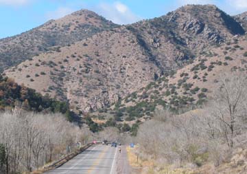
Descending Tijeras Canyon (west) in the Fall
|
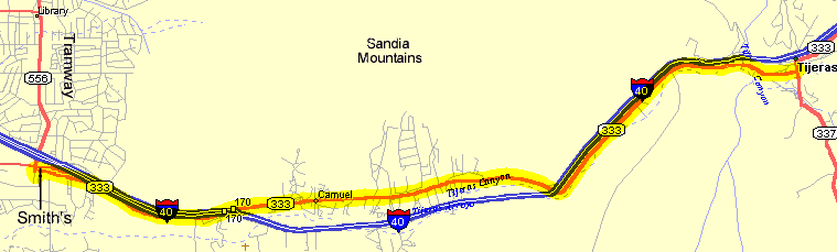
The Tijeras Trot is an extremely popular ride
from 4-Hills to Tijeras up the Tijeras Canyon between the Sandia and Manzano Mountains.. This is often the start
of other scenic rides on the east side. The route has only moderate climbing and has some nice shoulders and light
traffic. This out-and-back ride starts and ends at the 4-hill's Smiths. This ride up the Tijeras Canyon is a starting
point for many rides on the east side of the Sandias. You will certainly see other cyclists on this stretch.
Getting There: The ride typically starts on the east side of
Albuquerque at the junction of Central, Tramway, and I-40. Rides often park at the Smith's at this intersection.
Roadway: There are shoulders in varying conditions most of the
way. Keep an eye open for lots of debris, glass, and gravel on the shoulders. There is usually light traffic on
the weekend. Watch for the pairs of recessed manhole covers on the westbound (downhill)
shoulders from Tijeras to the I-40 underpass near Carnuel.
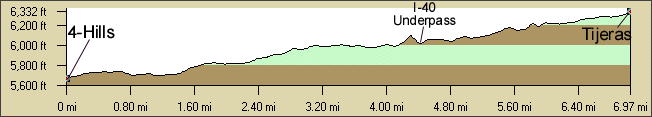
Distance: 14 Miles, 850 ft. elevation gain roundtrip, 4-Hills - Tijeras. It is mostly uphill going east, downhill on the return. The climb is only
easy to moderate, there are no steep sections.
Options: There are many options from Tijeras. Tijeras Canyon
is the start for most of the East Mountain rides popular in the summer: East
Mountain Rides, East Mountains South Rides Map |
East Mountains North Rides Map:
Oak Flat, Madrid Gold Rush,
Sandia Crest Climb, NM217
Rollers, Tajique Tango, Frost
Rd Loops, Heartbreak Hill, east side
mountain bike rides on NM337, and so on.
Notes: It can REALLY get windy (from the west) in the afternoon
up Tijeras canyon, get an early start. East winds in the morning and West winds in the afternoons are common. It
can be surprisingly cooler on the east side. There are also the summer thunderstorms to watch for.
The new Tijeras USFS Sandia
District Ranger Station is about 1/2 mile south on NM337 where you can get water, maps, bathrooms,
etc. when it's open.
|