 |
|
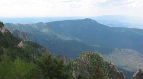
View South from Sandia Crest |
The climb goes through several vegetation zones and interesting geologic features. The route goes through ponderosa, aspen, and spruce forests. The aspens turn vibrant yellows and orange in the fall. The locust trees bloom in the spring along the lower elevations. Most of the year wildflowers line the highway.
You enter the Cibola National Forest just past Tinkertown.
The Sandias are relatively young, geologically. Road cuts display sandstone and limestone layers broken in different directions hinting at the forces at work raising the range. As you pedal past Doc Long, the Great Unconformity is visible in the road cut across from Doc Long. The rocks above the line are 250 million years old, those below are 1,450 million years old. The unconformity is a 1.2 billion year gap that has been eroded away then younger rocks deposited above.
At the summit on the observation deck, you are standing on fossil-laden Pennsylvanian limestone. There is a parking lot at the crest where there is a USFS visitor center and snack bar and gift shop. There are normally quite a few people at the crest but it is not congested. You might want to bring a light locking cable to be able to walk to the observation platform or south along the Crest Trail. There is a superb view of all of Albuquerque, Mt. Taylor, Ladron Peak, and the Jemez Mountains on the west.
The Sandia Crest Climb is a popular cycling route and you will normally see other cyclists on the road or meet them at the top.
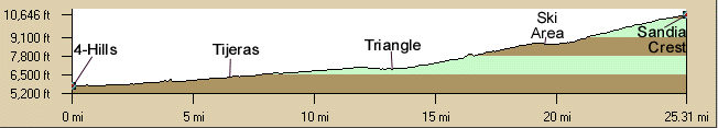
A popular summer evening ride is to start at the Triangle and ride up through the lengthening shadows to twilight and turn around before the downhill at the ski area.
NOTE: Due to the drought there is no water at the Doc Long Picnic Ground.
 |
|
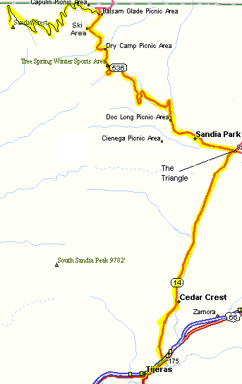
Route Map |
- 42 Miles, 4,880' of elevation gain from Tijeras.
- 56 miles, 5,730' from 4-Hills - See Tijeras Trot for a description of the ride through Tijeras Canyon.
Getting There: Depending on the distance and elevation gain desired, there are starting places at
- 4-Hills at Central and Tramway,
- Tijeras (at the library or post office), or
- The "Triangle" . The "Triangle" is the intersection of NM14, NM536 (the Crest Road), and Frost Road. There is a Shell station convenience store at this intersection.
Weather: Beware of afternoon mountain storms during most months of the cycling year. The weather on the mountain can be much different, and colder, than in the city. In the spring beware of icy spots in shadows from melting snow. A light rain jacket, arm and leg warmers can be lifesavers. Also, the mountain is not the place to be during lightning storms. Since most of the storms are in the afternoon, get an early start.
Roadway: There is light traffic from the Triangle to the Crest. There are shoulders about half of the way up. The road surface is in good shape, newly resurfaced. Watch for dirt on the tight corners. The upper road to the crest was built originally in 1923, paved in 1966, and rebuilt in the early 80's with the Ellis and 10-K trailheads and passing lanes and repaved in 2005 so it is in good condition at this time.
Watch for gravel at intersections in Cedar Crest on the descent on NM14.
Options:
- East Mountains South Rides Map | East Mountains North Rides Map
- Start at the "Triangle" to shorten the ride by 10 miles
- Start at 4-Hills to lengthen the ride by 13 miles.
- NM536 turns north at the Balsam Glade picnic grounds and is paved for a while but there is 7 miles of dirt road. It is rough but rideable but cars throw up clouds of dust.
- Evening riders often park at the Triangle and turn around before the descent to the ski area.
Notes:
- MapMyRide
map
- Due to the drought there is no water at the Doc Long Picnic Ground.
- See Tijeras Trot for a description of the ride through Tijeras Canyon.
- See the Sandia Crest Climb writeup in the book, Road Biking New Mexico by Nicole Blouin.
- There is a new snack bar at the Sandia Crest summit where you can purchase cold drinks and snacks.
- There is a convenience store at the Triangle.
- The Triangle Grocery Store is now in the Cedar Crest Shopping Center about 2.5 miles north of I-40.
- There is water at the ski area if it is open.
- There are bathrooms at the Doc Long, Tree Springs, Balsam Glade, 10K, and Ellis picnic areas or trailheads on the way up.
- Watch for the occasional road bike races to the crest that begin at 4-Hills or Nob Hill.
- The parking areas are "fee areas" but bicycles don't have to pay. Motor vehicles do have to pay if you drive up to mountain bike some of the trails.
- There can be a surprising amount of snow in the early spring that melts and runs across the roadway even when it is nice in town.
- East Mountains Area Map
- Great Outdoors' Great Hill Climbs of America
- Turquoise Trail Web Site
- Turquoise Trail National Byway
- Sandia Peak Ski & Tramway
|
||||||||||||||||||||||||||||