|
 |
|
Area Map
|
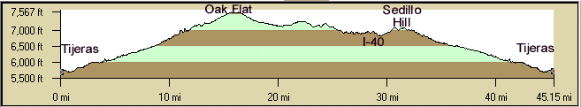
The NM217 Rollers, aka South-14 Rollers, is a favorite ride that can be combined with the Oak
Flat climb up S-14, Heartbreak Hill, and other rides on the east side of the
Manzanos. This is a great summer ride to get out of the heat of Albuquerque. This is a demanding ride but a lot
of fun. Since this is New Mexico it is often windy so start early. Take plenty of water and snacks. The rollers
are great fun. This ride has commanding views of the Manzano mountains and the Sandia Mountains. You can also see
Edgewood to the east. South NM14 has been renamed NM337. Historic route Route 66 is now NM333.
There are about seven big rollers between Martinez Rd. and I-40. Riding NM217 north to south is definitely harder
than south to north. You will normally see other cyclists on this popular circuit.
Distances:
- 45 miles, 2,655' Elevation Gain, from 4-Hills - Tijeras - Yrisarri - NM217 - NM333 (I-40 frontage road past
Zuzax) - 4-Hills.
- 39 miles, 3050' from Tijeras - Tijeras - Yrisarri - NM217 - Mountain Valley Rd. - Frost Rd. - NM14 - Tijeras.
- 54 miles, 3,750' from 4-Hills, the above 39 miles plus Tijeras Canyon.
Getting There: Start at the 4-Hills Smiths or Tijeras.
Options: There is 750' of elevation gain from 4-Hills to Tijeras, 1850' of gain in the loop from Tijeras
- Sedillo Hill - NM217 - NM337 - Tijeras.
- Anaya Loop: Take Anaya St. left from NM337 at the Ponderosa Saloon. Ride
north past Gonzales Rd. which turns into Oak Flat Rd and then connects to NM337 again at Oak Flat for a nice approximately
4 mile loop. Anaya has nice pavement and no traffic. There's three short but steep hills. There is a street sign
just north of the Ponderosa Saloon.
- East Mountains South Rides Map | East Mountains
North Rides Map.
- Shorten the ride by beginning at Tijeras, 39 miles, 3,050' elevation gain.
- Mountain Valley Rd (north of I-40) rollers to Frost Rd. This has new
pavement and shoulders part of the way. There are several rollers but some have shoulders..
- Take Frost Rd. East to NM344, north to Heartbreak
Hill, south on NM14. This results in a 60 mile, 5,000' ride.
- Take Martinez Rd. at the stop sign at the south east end of NM217, the
short out and back to the south east. This adds about 6 miles. Watch for dogs. There are several miles of
roads that wander through neighborhoods.
- You can also cut across from Oak Flat to NM217 at Gonzales Rd. This is about 6 miles
to NM217. Initially, it has some nice fast downhills through the trees. This cuts off several hills on the south
part of NM217 at Martinez Rd.
Roads: There are no shoulders on NM217 so watch the cars on the rolling hills. Most are courteous but
there is the usual number of jerks. There are "Limited Sight Distance" signs on the hills with speed
limits like 45mph or 35mph, but dream on.
A portion of the worst of the northern part of NM217 has been repaved (2006) - no shoulders of course! At least
the white line is not painted on grass.
There are shoulders on NM337 from Tijeras to the junction with NM217 at Yrisarri. Watch for rough spots and
debris on the downhill shoulders (northbound) on NM337.
Notes:
- The Morningside Grocery is just south of Oak Flat about 12 miles south of Tijeras (Kuhn Rd) for drinks or snacks.
There is also Jo Jo's Cafe there.
- There is a Shell convenience store at the intersection of Frost Rd and NM14 (the Triangle).
- There are bathrooms, information, and water at the Sandia Ranger station on NM337 just south of Tijeras.
If you have time, cache your bikes behind the ranger station and take the nice walk through the Tijeras Pueblo
ruins.
- The "Triangle" grocery store is now located in Cedar Crest at about milemarker 3. There's a Subway
in Tijeras, and two gas stations in Cedar Crest .
- There is a convenience store at Zuzax.
- The Juan Tomas road that runs from NM337 to NM217 has a couple of miles of dirt (mud) in the middle but is
a nice ride with a big hill east of Juan Tomas.
- Water and restrooms are available at the Oak Flat Picnic Ground, about a mile climb east of NM337.
|