|
 |
|
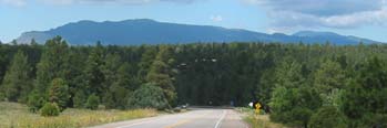
View North on NM337 at Pine Flat
|
The Oak Flat Out and Back is a nice ride on the east side of the Manzanos to beat the summer heat and get
some climbing in. Ride out Tijeras Canyon on Old Route66 (NM333) to Tijeras. Climb Old South 14 (NM337) past the
Tijeras Ranger Station up the winding road to the USFS Oak Flat Picnic Grounds through through the forested scenic
east mountains. NM337 climbs through pleasant Pondorosa forests past some pretty roadcuts hinting at the forces
that raised the Sandia and Manzano Mountains. There are terrific views of the Sandias on the downhill (north) side.
This is a moderate climb with no extreme grades.
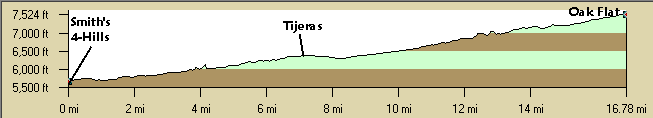
Distance: 32 Miles (from 4-Hills)
roundtrip. ~1,300 ft. climb from Tijeras plus 850' climb from 4-Hills, a moderate climb with no real steep sections.
Getting there: This discription
begins and ends at the 4-Hills' Smiths. See Tijeras Trot for a description
of Tijeras Canyon.
Roadway: NM337 has shoulders for
the most part up to Oak Flat and beyond to NM217. The downhill side is rough and usually has debris. NM337 and
NM333 have light traffic on weekends. NM337 seems to have more motorist jerks than north NM14 for some reason -
just ignore them.
 |
|
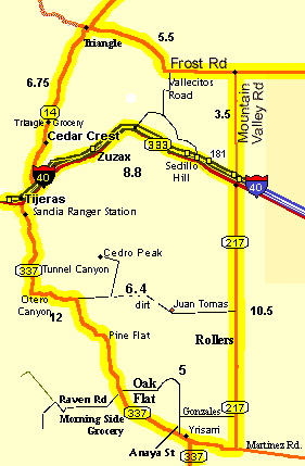
NM337 Oak Flat Route & Area
|
Options:
- There are many extensions in the area, most notably, continue south on NM337 to the NM217
Rollers.
- From NM337, follow the Oak Flat road east past the picnic area up a slight rise for a nice downhill through
pine forests on Gonzales Rd to NM217. Then left (north) to I-40, Frost Rd., Heartbreak Hill, or turn right and
circle back to NM337.
- Anaya St. Option: From the Morningside grocery, ride south, downhill, 1.6 miles
on NM337 to Anaya Street, just before the Pondorosa Saloon Take Anaya St. left from NM337. Ride north on Anaya
St past Gonzales Rd., there are three hills, which turns into Oak Flat Rd and then connects to NM337 again at Oak
Flat for a nice approximately 4 mile loop if you're doing an out and back on NM337. Anaya St. has nice pavement
and no traffic.
- There are a number of great mountain bike single and double track trails that begin in the Oak Flat area. Connecting
these together you can ride all the way south to old RT66.
- A terrific map of the mountain bike trails on the east side, The Trails of Cedro Peak & Otero Canyon,
($7) is available from the USFS Sandia Ranger Station in Tijeras or area bicycle shops.
- The Ponderosa Trail / Trail 8 is just east of Oak Flat connecting at the paved Oak Flat Rd.
- Across NM337 take Raven Rd to Mars Court (there are street signs) to a maze
of logging roads and trails. These begin as easy dirt logging roads right off Mars Court. These connect with other
trails that meander down to Cedro Creek.
- See East Mountain Routes | East Mountains South
Rides Map | East Mountains North Rides Map.
Notes:
- Just past (south) Oak Flat is the Morningside Grocery and Jo Jo's Cafe at Kuhn Rd. where you can pick up snacks
and is a popular cyclists' stop.
- There are bathrooms, information, and water at the Tijeras Ranger station on NM337 just south of Tijeras.
If you have time, cache your bikes behind the ranger station and take the nice walk through the Tijeras Pueblo
ruins.
- Cibola National Forest
- See the Sandia District, Recreation Sites. There are water hydrants at some of the group picnic sites in the
USFS Oak Flat Group Picnic Ground.
- It can REALLY get windy (from the west) in the afternoon in Tijeras canyon, get an early start. East winds
in the morning and West winds in the afternoons are common.
- Watch for debris / glass /dirt on the shoulders in Tijeras Canyon.
- The Juan Tomas road that runs from NM337 to NM217 has a couple of miles of dirt in the middle but is a nice
ride for mountain bikes with a big hill east of Juan Tomas. There is a big sign at the turnoff on NM337 for Cedro
Peak Campground.
- Cedro Peak is on a gravel road north of the paved Juan Tomas road.
|