Taos Dixon - US Hill Loop


Route Map

Route Map

The Taos Dixon - US Hill Loop is a scenic, moderate road ride in northern New Mexico south of Taos that has a fair amount of climbing and rides through sections of the hilly, ponderosa forested Carson National Forest. Taos (elev. 6,965') is a very popular tourist area and has a lot of road and mountain biking in the area.

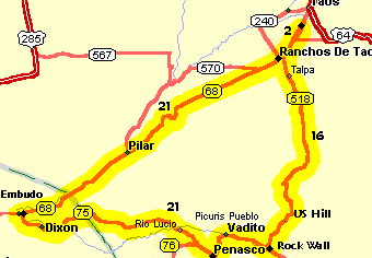
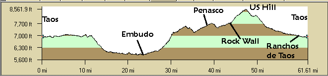
Once out of Taos and Ranchos de Taos, the route follows the Rio Grande south on NM68, the Kit Carson Highway, through a spectacular gorge where you can often see rafters and kayakers on the Taos lower "box" or the Racecourse. In the spring the Rio Grande runs fast and there are some great pullouts where you can watch the rafts go by just below. There is an annual Mother's Day race in the Racecourse. At Pilar at the intersection with NM570 there is the BLM Rio Grande Gorge Visitor Center. NM570 follows the Rio Grande upstream through the Orilla Villa Recreation Area that used to be known as the Rio Grande Gorge State Park. Riding downstream past Pilar you go through dramatic volcanic cliffs along NM68. Then the Rio Grande becomes more tranquil and the canyon starts opening up just before the intersection with NM75 at Embudo. There is usually a lot of traffic on NM68 but it's not too bad on weekend mornings and more of it will be going towards Taos.

Turning east on NM75 you ride along the pleasant Rio Embudo to Dixon. There is little traffic for the rest of the ride. Past Dixon you turn a little north, begin climbing, and enter Picuris Pueblo, "those who paint", lands. After a short descent continuing on NM75 you pass the entrance to the pueblo on the left. There are some good views along here of some of the northern Truchas peaks, Trampas, Jicarilla, and Jicarita peaks, which may be snow-capped in the spring.

Continue on NM75 at the intersection with NM76. NM76 turns south towards Truchas and Chimayo, the "high road to Taos", which is part of a great ride, the Mora Maddness.

Staying on NM75 you ride into pastoral, green, Penasco. Turn north in town and climb over into the Rio Pueblo drainage. Follow the Rio Pueblo through the little town of Vadito and continue to Rock Wall at the intersection with NM518.

At NM518 there is a steep 800' climb to U.S. Hill though the heavily forested Carson National Forest. This is a GREAT descent when riding in the opposite direction. The summit pulloff at U.S. Hill has some good views but mostly you're in the trees.

The excellent 10 mile descent to Talpa is well-deserved with good pavement and is long and straight. Once in Ranchos de Taos ride north back to Taos through the suburbia traffic..

Since this is a loop it can start and end at any location and be ridden in either direction.

Getting There: This write-up starts and ends at the Taos Wal-Mart, 0.6 miles north of the NM68 & NM585 intersection. Or, being a loop, start anywhere on the loop or ride the loop in the opposite direction.

Nicole Blouin, below, recommends using the Taos Visitor Center for the start/end location at the intersection of NM68 and NM585 in south Taos.

Distance: 60 Miles, 4,100' elevation gain.

Roadway: Mostly 2-laned highway. NM68 has lots of traffic through Taos so ride the NM68 section early in the morning. NM68 is 4-laned with a shoulder from the center of Taos south to Ranchos de Taos. NM68 south of Ranchos de Taos is 2-lanes. NM75 is 2-lanes with light traffic. NM518 has light traffic on weekends and very little traffic east of Talpa. There are some shoulders on NM518 from Ranchos de Taos to about Talpa. There is considerable traffic at the NM515/NM68 intersection at Ranchos de Taos.

Options:

  • North of Taos there is a rough shoulder on US64 to about the turnoff to the Taos Ski Area Climb. The section of US64 from the center of town to about the bypass has pretty heavy traffic.
  • Since NM68 in Taos is not much fun, there is a school on NM515 just east of Ranchos de Taos where you might park on the weekend.
  • See also the Taos High Country Tour (Enchanted Circle), the Southern Enchanted Circle Tour, and the Taos Ski Area climb.
  • NM570 is a pleasant road along the Rio Grande in the Orvilla Recreation Area at Pilar.

Notes:

  • Refer to the detailed "Dixon-Penasco Challenge" in the Falcon book, Road Biking New Mexico, by Nicole Blouin, for more information.
  • There is every kind of motel and fast food place south of Taos on NM68 roughly south from NM585 south to Ranchos de Taos.
  • There's a hostel and a store at Pilar. The Embudo Station south of Embudo on the Rio Grande is (was?) a nice place to eat, though time-consuming. There's a small store in Dixon. There is a food store in Penasco and there may be one in Vadito. There are no supplies from Rock Wall to Talpa.
  • The BLM Rio Grande Gorge Visitor Center is located at NM68 and NM570 in Pilar.
  • There are numerous good mountain bike trails in this area such as the forest road out to Picuris Peak (8 miles each way).
  • The annual Red River Enchanted Circle Century begins and ends in Red River sponosored by the Red River Chamber of commerce, usually the Sunday after Labor Day. Ridden counter-clockwise from Red River with a leg out and back from Angel Fire to make 100 miles.
  • Outside of Dixon is the Harding Pegmatite mine - there are still some colorful pegmatite crystals in the mine.
  • There are a number of bike shops in Taos and a few may rent mountain bikes or arrange shuttles, see the web yellow pages.
  • There are several books that describe the popular mountain biking trails in the Taos area.


Cusheet

Taos Dixon - US Hill Cuesheet // 60 Miles
Mileage Waypoint Leg Description

0

Taos Start and end at the Taos Wal-Mart on the south side of town.
Ride south out of Taos on NM68 all the way to Embudo.

2

Ranchos de Taos Ride straight through (south) on NM68 at Ranchos de Taos and NM518, the intersection with the return route. Several desents to Pilar.

15

Pilar, NM570 Continue straight (south) on NM68 to Embudo. The BLM visitor's center.

23.5

NM75, Embudo Turn left (east) at Embudo and ride on NM75 along the Rio Embudo to Dixon (26.8) and on to Penasco.
Continue straight on NM75 at the NM76 intersection. There is a food store in Penasco and a small store in Dixon.

25.5

Dixon Continue straight on NM75 to Penasco. Climb out of Dixon and then down into the Picuris Pueblo.

39

Penasco Stay on NM75 as it turns left and climbs to Rock Wall to Vadito. There may be a convienence store at Vadito.

40.8

Vadito Continue on NM75 uphill to Rock Wall.

44 

NM75/NM518 Rock Wall Turn left (north) and climb steeply from Rock Wall to the summit of U.S. Hill.

47.3

U.S. Hill U.S. Hill summit turnout where you stop for a break. Then a nice unbroken 12 mile descent through Talpa and to Ranchos de Taos. The route curves to the west.

59.6

Ranchos de Taos, NM68 Turn right (north) on NM68 into Taos. Traffic but shoulders on NM68. Congested at Ranchos de Taos. There's a convience store on the other side of the intersection.

61.5

Taos Starting point.

Profile