 |
|
Area Map |
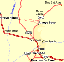
Getting There: The intersection of US64, NM522, and NM150 is about 4 miles north of Taos the center of Taos. This is the turnoff to the Gorge Bridge to the west and Arroyo Seco and the Taos Ski area to the east. You can start in Taos but there is a lot of traffic on US64. Also, you can start in Arroyo Seco.
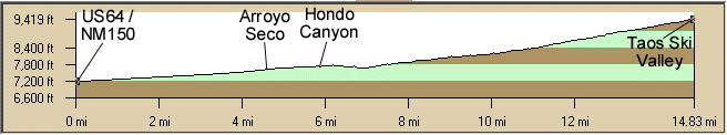
Distance: 30 miles round trip, 2,500' elevation gain
Roadway: It is paved in various states of maintenance. It is two lanes without shoulders with light east of Arroyo Seco traffic.There is moderate, fast traffic through here so you might want to start at Arroyo Seco.The traffic on US64 north of Taos is fairly heavy but there are useable shoulders to the Gorge Bridge turnoff. Taos is fairly congested but once you get away from Taos the roads are light to moderate traffic.
Options: This is a fairly short ride. There are nice portions of the The Taos High Country Loop, the Southern Enchanted Circle Loop (USA Hill), Taos-Dixon US Hill Loop or the out of Taos. There is also a lot of good mountain biking in the area.
Notes: There are several bike shops in Taos and a mountain biking book on the Taos area.