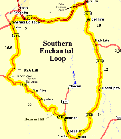
| Mileage |
Waypoint |
Leg Description |
|
0
|
Start and end in Ranchos de Taos, at the intersection of NM68 & NM518. |
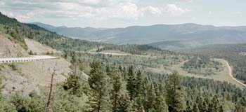
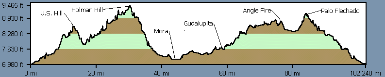
Travel southeast on NM518 through Talpa, climb US Hill (1 false summit) to
US Hill. There is a nice turnout just before the summit. |
|
16
|
Jct with NM75 at Rock Wall |
Screaming downhill, Whee!. - Continue left on NM518. There are a couple of
small stores along the way. Minimal traffic after this turn. |
|
20
|
Sipapu Ski Area |
Continue on NM518 |
|
36
|
Jct with NM121 |
Stay right on NM518, climb Holman Hill, the easy side. Stop and enjoy the
vistas at a few turnouts, including Hermit Peak before the terrific downhill into Holman. There are a few campgrounds
with bathrooms along the way. |
|
37
|
Holman |
Continue on NM518. Several convenience stores. |
|
41
|
Cleveland |
Continue on NM518. |
|
44
|
Mora |
Turn left on NM434 (the left
turn is in town on a small street at a white building - easy to miss). |
|
58
|
Guadalupita |
Continue on NM434. Now come several steep climbs. However, the route follows
a narrow road along a wooded canyon, following a stream that is one of the highlights of the trip. |
|
69
|
Jct NM120 |
Continue left on NM434. Now out in the Moreno valley, enjoy the distant vistas.
Once in Angel Fire there is a grocery store and other services. |
|
80
|
Jct US64 |
Turn left on US64. 2 mile ascent to the pass but not too bad of a climb.
Narrow road with guard rails. Beware of Texans dragging house trailers around narrow switchbacks cutting you off. |
|
84
|
Palo Flechado Pass (9200') |
Continue on US64, enjoy the fast downhill. There's a bit more traffic on
this stretch into Taos. Be careful of a few potholes in the old pavement on the downhill. There may be a "Bicyclists
Ride Single File" sign. Unfortunately, this is mainly in the trees without much of a view. |
|
99
|
Jct US64 & NM585 |
Turn left on NM585, follow the "Santa Fe" sign. The right turn takes you into
the center of Taos and lots of traffic. |
|
103
|
Jct NM68 |
Traffic light - Turn left (south) This is the main drag into Taos so there
is a lot of traffic. |
|
104
|
Ranchos de Taos |
Finish line, Hoorah! for this superb ride. |