Taos High Country Tour


Bobcat Pass

Ascending Bobcat Pass from Red River

The Taos High Country Tour, also know as the Enchanted Circle, is one of the most favorite tours in New Mexico. Many of the commercial and charity rides include this scenic loop in their tours. THCT has spectacular vistas of northern New Mexico's Enchanted Circle. Gaze at the highest peaks of New Mexico, ride over challenging passes, and scream down awesome downhill runs. Ride through the beautiful Moreno valley.

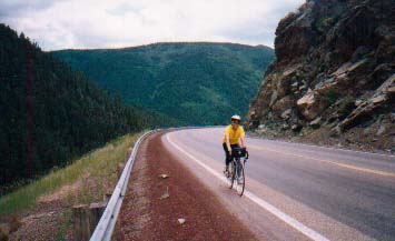
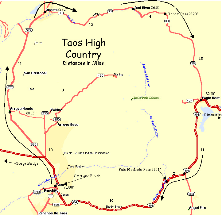
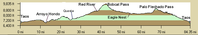
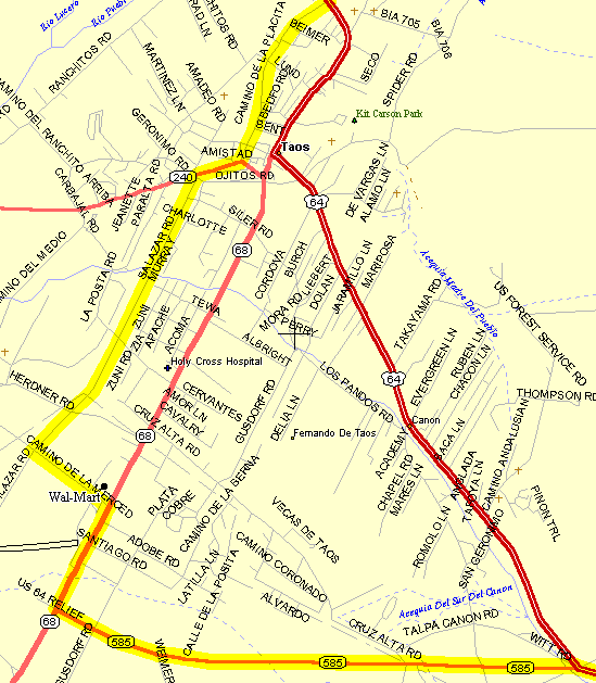
The ride from Taos to Questa ascends some large rolling hills with open vistas of the mountains east of Taos and the area of the ski area. Then you are rewarded with the high speed descent into Questa which is one of the finest in the state: straight, clean, fast, and lots of visibility.

The moderate climb up the Red River canyon from Questa to Red River is truly spectacular. Colorful cliffs line either side of the canyon as you ride through the national forests following the pretty Red River. The large mine tailings above on the canyon walls are part of the closed Molycorp molybdenum mine. You pass several USFA campgrounds. Once in Red River check out all the tourist traps but it is a pretty town.

There is a steep 4 mile climb up Bobcat Pass (9,820') but only the first two miles from Red River are hard. Then there is a lovely 13-mile descent from Bobcat to Eagle Nest through the beautiful Moreno Valley and it's mostly downhill the entire way. (Watch for the field-dragon). The Disabled American Veterans Memorial is between Eagle Nest and Angel Fire.

From the intersection at Angel Fire, US64 up and over Palo Flechado Pass (9,101') is narrow and there are a few switchbacks where you need to watch so that you don't get side-swiped by an R/V who has never driven on a hill.

Since this is a loop tour you can choose to start and end anywhere.

There is an unmarked bypass that begins south of Taos at NM68 & NM585 that goes west to Salazar Rd. then north through the plaza to the red light north of town.

Getting There: Start and end in Taos at the Wal-Mart, or being a loop anywhere on the loop.

Distance: 89 Miles, 5,300' Elevation gain.

Roadway: Mostly 2-lane highway. There are some shoulders from Taos to Questa to Red River and some newer pavement replacing the really bad parts on NM522 between Taos and Questa. There is more traffic from Taos to Questa then else. NM68 N/S has lots of traffic through town so avoid NM68 in Taos. Watch the traffic over Palo Flechado Pass. There's some newer pavement from Angel Fire to Eagle Nest. Ride single file on the west side of Palo Flechado Pass (signs). There often is heavy traffic in the center of Taos by the afternoon. The descent from Palo Flechado Pass towards Taos is marked "Bicycles - Ride Single file" but is a great descent. Watch for incompetent RV drivers going up the switchbacks to Palo Flechado Pass.

Options:

  • Add a Arroyo Seco to Arroyo Hondo leg north of Taos (10 miles) toward the ski area.
  • Take US64 west to the Rio Grande Gorge bridge out and back 7 miles each way. The gorge is like a mini Grand Canyon and is quite spectacular and is worth the side trip if you've never seen it. It's slightly downhill to the river. NM4 continues on to Tres Piedras. The Gorge Bridge is pretty awesome.
  • Add a leg from Eagle Nest to the Palisades west toward Cimmarron. (6 miles). It's downhill from Eagle Nest.
  • Ride through the center of Taos on US64 to check out the plaza on the return.
  • Ride the entire loop in one day, in either direction. Another option is to begin in Eagle Nest and ride the circle in one day, counter-clockwise.

Notes:

  • See also the Southern Enchanted Circle Tour.
  • Annual Red River Enchanted Circle Century - Begins and ends in Red River sponosored by the Red River Chamber of commerce, usually the Sunday after Labor Day. Ridden counter-clockwise.
  • There is every kind of motel and fast food place south of Taos on NM68 roughly from NM585 south to Ranchos de Taos.
  • NM68 south of town follows the Rio Grande where there is lots of rafting and kayaking. There's a BLM visitor's center at Pilar.
  • Red River: There is water and public bathrooms in the city offices in the middle of town on the north side of the road. There is a new city building south of the park in the middle of town. There is a couple of gas stations, a grocery store in the middle on town, and lots of resturants.
  • Eagle Nest: There is the Moore Rest Motel, several resturants, and a gas station at the intersection of US64 & NM38.


Day 1 (53 miles, 4,100 feet elevation gain)

Taos High Country Day 1 Cuesheet // 53 Miles 4,100' Elevation Gain
Mileage Waypoint Leg Description

0

Taos Start and end at the Taos WalMart on the south side of town.Ride north on NM68 past Arroyo Hondo climbing the rolling hills to Questa. (24 miles, 2000 ft elev gain)
Enjoy one of the best downhill runs into Questa.
Option: At 4 miles - Turn right (east) at the red light intersection to the Gorge bridge to Arroyo Seco, turn left at the Abominable Snowmansion Hostel, then ride through Arroyo Hondo to NM68 then north to Questa.
Option: Turn left (west) and ride 7 miles to the Rio Grande Gorge Bridge and return.

24

Questa Turn right (east) on NM38 to Red River (12 miles, elev gain 1,000 ft.). Pass the now shut down MolyCorp mine up the beautiful Red River canyon with spectacular cliffs on both sides. This is one of the prettiest stretches in the state with low traffic. NM38 has shoulders and a nice surface.

36

Red River Enjoy lunch at one of the many resturants or grocery store. Continue east through Red River on NM38 up to Bobcat Pass (9800 ft.) (4 miles, 1100 ft elevation gain). (The first 2 miles are the worst)
There is water and public bathrooms in the city offices in the middle of town on the north side of the road.

40

Bobcat Pass (9820') Photo op! Rest, then continue downhill 13 miles on NM38 to Eagle Nest (watch for the meadow dragon).

53

Eagle Nest Turn left (east) at the intersection with US64 and ride through town about 1/2 mile to the Moore Rest Motel on the east side of town.
    Option: Ride downhill East from Eagle Nest toward Cimarron to the Palisades (6 miles) and back to view the spectacular canyon and volcanic formations.


Day 2 (34 Miles, 1,100 Feet Elevation gain)

Taos High Country Day 2 CueSheet // 34 Miles 1100' Elevation Gain
Mileage Waypoint Leg Description

0

Eagle Nest Ride south in the lovely Moreno Valley on NM38 past the DAV Memorial (worth a visit if you haven't been there before) then right (west) at the turnoff to Angle Fire. Climb the switchbacks up Palo Flechado Pass (9200 ft) (10 miles, 1100 ft. elevation gain) for a well deserved break. There is some new pavement on NM38 but the climb up Palo Flechado is narrow. Luckily, in the morning there is light traffic.

10

Palo Flechado Pass (9200 ft) Continue west on NM38 downhill to the intersection with NM538. This stretch has no shoulders and has traffic so ride single file.

32

Jct of NM538 & NM38 Turn left (south) onto NM538 ("To Santa Fe") to the intersection with NM68 (2 miles). This seems wrong but if you take the right fork you wind up at the center of Taos.
Option: Turn right (north) here and ride into the center of Taos. Shop, then left (south) back to Wal-Mart. There is usually heavy traffic in Taos.

34

NM68 Turn right (north) for 2 blocks to Wal-Mart.

Route Map

Map

Elevation Profile

Elevation

Ignore the small spikes which are artifacts of the data.

Taos City Detail

Salazar Rd. to Camino de la Placita can be used to bypass heavy traffic in the center of town.

Taos