| Mileage |
Waypoint |
Leg Description |
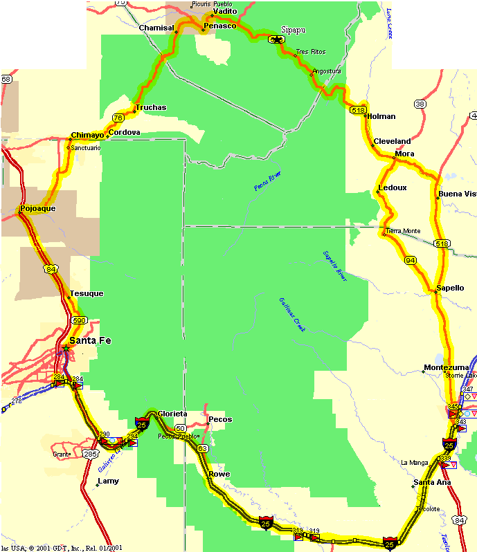
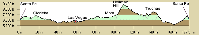
| Day 1 - Santa Fe - Las Vegas (66 Miles): |
|
0
|
Santa Fe |
Start at a convenient location in Santa Fe such as this description the Capshaw
School at St. Francis Rd and Zia. There is also a KOA at exit 294 on I-25. Follow the frontage road as far as Apache
Canyon, exit 294, then ride the rest of the way on the shoulder of I-25 which is normally in OK shape. There are
frontage roads on only one side of the road from about Pecos to Las Vegas, wandering from the north to south side
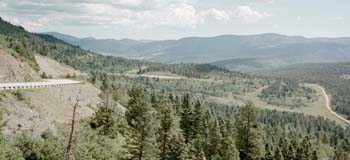
of I-25. Day 1 has longer miles but not a lot of climbing. It is in the open so east winds could be bad news. |
|
66
|
Las Vegas |
The club has stayed at the KOA 1/2 mile south off I-25 at exit 339. or you
can stay in Las Vegas at the historic Plaza hotel in the center of town. |
| Day 2 - Las Vegas - Sipapu (47 Miles): |
|
0
|
Las Vegas |
Take the frontage road on the SE side of I-25 from the KOA 4 miles to Grand
St, exit 343 and turn left (north).
Follow Grand north 1.75 miles to Jackson, where NM518 begins on the left. There's junkfood on the corner so this
is a place for breakfast.
Turn left (north) on NM518. Follow NM518 north out of Las Vegas, past Storrie Lake Park, to Sapello. |
|
18.7
|
Sapello - Jct with NM94 |
The route stays on NM518 (17.2 Miles).Stay on NM518 out of Sapello 12 miles
to the junction with NM442. Take NM518 left (west) to Mora (5.2 miles).
Option (18.3 miles): Turn left on NM94. This route is much more hilly and a little longer, pass Leroux , climb
Cebolla Pass and ride downhill into Mora. |
|
36
|
Mora |
There is a convenience store/gas station in town for a snack. Continue east
on NM518 through Cleveland to Holman (23.4) then climb the switchbacks up Holman hill. Holman Hill gives a great
view of east. The route now passes through high forested pasture lands. Pass through Angastora and there may be
a small store here. Continue on through the forest to the Sipapu Ski Area. |
|
47
|
Sipapu |
Make arrangements to stay at one of the ski motels / ski area dorm. There
are a few places to eat at the small ski area. Sipapu Web Site. |
| Day 3 - Sipapu - Santa Fe (almost 44 Miles): This day goes pretty fast it's largely downhill. |
|
0
|
Sipapu |
Continue east from Sipapu on NM518 to NM75 |
|
4.7
|
Jct NM75 |
Turn left onto NM75 at Rockwall. Pass through Vadito, turn right in Penaso
stay on NM75 to the Jct with NM76. |
|
11.5
|
Jct NM76 |
Turn left (south) on NM76 through Las Trampas, Truchas, to Chimayo. |
|
33
|
Chimayo |
Chimayo - visit the Sanctuario. Take NM503 south out of town and 502 and
NM4 to the junction with US84. |
|
44
|
Jct US84 at Nambe |
US84/285 is the main road from Santa Fe to Espanola. The traffic is terrible
Somewhere here or in Pojaque is where you want to get picked up. The roads are heavily used and not designed for
cyclists at all sadly. |
|
53
|
Tesuque |
Turn off (left) to Bishop Lodge Road. Narrow picturesque road that leads
into Santa Fe. |
|
60
|
Santa Fe City Center |
This is the intersection with Paseo de Peralta, just for info. You are now
in the center of Santa Fe. Sadly, Santa Fe is also not bicycle-friendly at all. |