Si New Mexico
Bicycle the Land of Enchantment 

Si New Mexico is a north to south cross-state road ride running mostly north to south from Colorado to old Mexico. Many options are possible. There is a Great Divide moutain bike route established by Adventure Cycling.

This route is a work in progress since the highway system is always changing, not always to the betterment of bicycling. In particular, the roads in the Santa Fe area is hazardous. Expect several days of 2000+ feet of climbing. The options below are one-way north to south routes and require a pickup at the end of the ride.

Getting There: Hey, New Mexico is a U.S. state, we have interstates and everything. It's the big sparse area west of Texas or south of Colorado or east of Arizona.

Notes: New Mexico is a desert state so always know where your next water will be, especially in the southern part of the state. There are mountains in New Mexico so don't be surprised with a lot of climbing or high elevations. Also, take care for the weather's high and low extremes. Summer thunderstorms are common in the summer. Spring is windy.See Getting Started for more general notes on cycling in New Mexico. There are no saguaro cacti in New Mexico - that's Arizona.

Chama to El Paso Option
Antonito, CO to El Paso, TX
East to West

Chama - El Paso Option
Chama to El Paso Option


Si New Mexco: Chama to El Paso Option: 800 Miles

This option is more picturesque but not as direct as following the US285/I-25 corridor in the Antonito to El Paso,Central Si NM Option below.


Si New Mexico - Chama - El Paso (Central NM) CueSheet // 800 miles
Mileage Leg Leg Description

57

Chama-Abiquiu Follow NM84 from Chama past Tierra Amarilla, past NM96 to Abiquiu.

Option: Add Cumbres Pass (Colorado Border) to Chama, 10 miles, to start at the Colorado state line. You could start in Antonito and add a day.
Abiquiu - Albuquerque Options
 
Option 1:  Abiquiu - Santa Fe - Albuquerque (Most direct but Santa Fe is not a pleasant bike ride)
Leg Mileage Leg Leg Description

50

Abiquiu - Santa Fe Follow NM84 to Espanola. Follow US285 to the Los Alamos turnoff. Follow 84/285 to Pojoaque.
At Tesuque, turn east onto Bishop Lodge Road to Alameda Rd. to downtown Santa Fe.


Option: Take the Santa Fe Bypass, NM599 from US285 north of Santa Fe around Santa Fe under I-25 to NM14.

77

Santa Fe -Albuquerque Follow NM14 from Santa Fe south to Tijeras past Cerrillos, the old mining towns of Madrid and Golden, then west on old RT66(NM333) to Albuquerque. There are grocery stores in Madrid, San Anonito, and Tijeras.
Option 2: Abiquiu - Los Alamos - San Ysidro - Albuquerque

77 

Abiquiu - Jemez Springs Follow NM84 to Espanola.  Follow NM5 through the Santa Clara Reservation to NM4. Take NM4 west to Los Alamos (40 miles). Continue on NM4 through the beautiful Valle Grande to Jemez Springs. There are some hard climbs up to Los Alamos and into the Jemez. There are some nice B&B's in Jemez Springs, the hot springs to soak, and it is a very pretty setting.

50
(Tramway & I-25)

Jemez Springs - Albuquerque Follow NM4 south to NM44 at San Ysidro.  Follow NM44 east to Bernalillo.  Follow NM85 south to Albuquerque at Tramway & Fourth Street. Follow  Fourth street to Alameda, west to the Alemada Bike path, the bike path south under I-40, continue past Rio Bravo to its end at 4th St.  Continue south to I-25.
Option 3: Abiquiu - Espanola - Mora - Las Vegas - Albuquerque

 70

Abiquiu - Sipapu Ski area Follow NM84 to Espanola.  Follow NM76 through Chimayo, Truchas, Las Trampas to NM3.  Go east to Sipapu.

 55

Sipapu Ski Area - Las Vegas Continue east to Mora then south to Las Vegas.

66 

Las Vegas, NM - Albuquerque Travel west on the I-25 fontage road to Santa Fe. Avoid the Old Las Vegas Trail road that is north on I-25 since it is in awful condition, take the I-25 shoulder, it's not as pleasant but much safer.  You can get off I-25 at St. Francis Rd, ride north to Rodeo Rd, then west to Cerrillos Rd, then south under I-25 as this turns into NM14. Take NM14 south to Tijeras.  Take NM333, old US66, west to Albuquerque.
Albuquerque - El Paso Leg
Mileage Leg Leg Description

78

Albuquerque - Socorro Take NM47 to US60 at Bernardo. Take NM 47 south to Socorro.

62

Socorro - Datil Follow US60 west through Magdelana, past the VLA, to Datil. This is pretty sparse so pick up water at Socorro and Magdelana. The Very Large Array, a radio telescope array (movies: Contact, 2010) is worth a stop if you have time. An interesting composite: world class high tech in the midst of western ranches and open expanses.

72

Datil - Reserve Follow NM12 south to Reserve. Light traffic.

35

Reserve - Glenwood Follow NM12 SW to US180 and south to Glenwood.

92

Glenwood - Lake Roberts Follow US180 south to Silver City, north on NM15 to NM35 and east to Lake Roberts in the Gila National Forest. This is the Gila Inner Loop which is very scenic and has little traffic. There is some climbing.

48

Lake Roberts - Kingston East on NM35 through Mimbres to NM90, east to Kingston. This crosses Emory Pass, noted by Bicycling Magazine as one of the best climbs in the country.

90

Kingston - Las Cruces East on NM90 to Hillsboro, south on NM27 to NM26, East to US85, south to Las Cruces. This route mainly follows the I-25 corridor south.

45

Las Cruces - El Paso South on NM28 to El Paso.

SI New Mexico, Antonito, CO to El Paso, TX ,Central Si NM Option

This option generally follows US285 & I-25 north to south but is not as picturesque as the option above.

Si New Mexico - Antonito, CO - El Paso, TX (Central NM) CueSheet
Leg
Mileage
Leg Leg Description
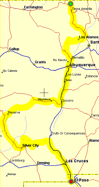
Antonito, CO to Taos, NM - 71 Miles

0

Antonito, CO - Taos, NM Ride west from Antonito, CO to US285, turn south. There is basically nothing until Tres Piedras so stock up on water and food at the store in Alamosa. Pass the San Antonio Peak, look for antelop. There is a good shoulder for a while, then about 10 miles of no shoulder before Tres Piedras. Moderate, fast traffic.

60

Tres Piedras, NM64 Turn east onto NM64 towards Taos. Cross the Rio Grande Gorge Bridge. What a view! (do some BASE jumping). Light traffic.
  NM522 Turn south to Taos.

90

Taos There are lots of motels on the south end of town. Heavy traffic in the center of town. There is a bypass around the center of town, see the Taos High Country Tour writeup. There is a motel at Ranchos de Taos. Follow NM68 and US64 to Ranchos de Taos.
Ranchos de Taos to Santa Fe - 72 miles (depending on destination in Santa Fe)

 17

Rachos de Taos: NM518 Turn left (east) in the center of Ranchos de Taos. See this writeup in the Southern Enchanted Loop. Climb US Hill and fly down to NM75.

 7

NM75 Turn right on NM75, ride through Vadito to NM76.

 22

NM76 Turn right on NM76 through Las Trampas, Truchas, Cordova to Chimayo.

 5

NM503 Left on NM503, rolling hills then downhill to NM4.

7

NM4 Follow NM4 to the traffic light with US285. This is the unavoidable (so far) awful stretch. If possible, get sagged to Santa Fe.

 17

US285 Left (south) on US285, don't turn to Los Alamos but pass the intersection to the Casino and stay on US285. heavy, fast traffic use the frontage road or the wide shoulders. There are several fast food places. Continue on to Pojaque past the Camel Rock Casino and Camel Rock. Rolling climbing hills with good views of the Sangre de Cristo Mountains and the Santa Fe Ski area.


Santa Fe Coming into Santa Fe there are several options:

Bypass Santa Fe: Take NM599 all the way around Santa Fe on the west side to NM14/I-15.
Center of Santa Fe: Stay on US285, at Tesuque, turn left (crossing the traffic) onto Bishop Lodge Road. Take this to the center of Santa Fe.
Santa Fe to Albuquerque or Mountainair - 69/92/110 miles

 49

NM599/NM14 From either NM599 or Santa Fe Ride south on NM14, relax, pass through Cerrillos, climb past the old mining town of Madrid, fast downhill through Golden, winding along with terrific views of the Sandia Mountains to Antonito. There is a grocery and several convienence stores here.
continue south on NM14 to I-40/RT66.

 61 / 8

NM333(Rt66) Continue south on NM14 to the traffic lights at Tijeras. There are several options here.
Albuquerque: Take RT66 west 7 miles to Albuquerque throught the Tijeras Canyon.
Mountainair: At Tijeras, turn south on NM337 to NM55 to Mountainair (60 miles) at US60. Take US60 west to Bernardo at I-25. This is quite a pretty ride but there is not many places to stay until you get to Mountainair. Then rolling hills to I-25.

52 / 92 

  Santa Fe to Mountainair Option: Take US285 south out of Santa Fe past Lamy turn right on NM41, ride through Gallisteo, Stanley to Moriarty (52) this could be an additional day. There motels and places to eat in Moriarty. Then continue south on NM41 through Estancia, this is a really nice ride to US60. Then west on US 60 about 12 miles to Mountainair (92 miles).
Albuquerque/Mountainair to Socorro - 77/65 miles
    Albuquerque - Bernardo(52) - Go south on NM47 (2nd st) to Belen then west to the center of town then south on NM116. The distance depends on where you begin in Albuquerque.
Mountainair - Bernardo(40) - Take US60, rolling hills down to Bernardo.

 52
40

Bernardo:US60 & I-25 The options come together at Bernardo. Head south on the I-25 shoulder.  There is a frontage road through Lemitar but why bother. The frontage road begins at San Acacia to Socorro.

25

Socorro There are lots of motels and places to eat and grocer stores. The intersection with US60 is on the south end of town.
Socorro to Truth or Consequences - 81 miles

 0

Socorro: US60: Ride south on the I-25 frontage road past the Socorro airport which crosses I-25 to the east and continue on what becomes NM1 south to San Antonio.

 11

Socorro - San Antonio & US380 Continue east south on NM1 towards the Bosque del Apache wildlife refuge. The visitor's center is 9 miles south of US380. Be careful crossing the railroad tracks. There is a visitor center, bathrooms and water at the Bosque.

 9

San Antonio - Bosque del Apache Continue south on NM1 which parallels I-25, crosses under to the west side. One stretch forces you to ride on I-25. You're following the Rio Grande valley. There are no services until Elephant Butte reservoir. NM1 contines to Truth or Consequences.

 61

Bosque del Apache - Truth or Consequences There is food and motels available at Truth or Consequences, named after the TV game show of the same name. Continue south on NM187 which parallels I-25 to the intersection to NM152 where there is a campground on the east side of I-25.
Truth or Consequences to Las Cruces - 80 miles

 0

NM187 & NM152 Continue south on NM187 that parallels I-25. Pass Caballo State Park and Lake, the towns of Derry, Garfield, and Salem to the intersection of NM26 to Hatch.

 80

NM26 & NM187 Continue south on now NM185 to Radium Springs and onto Las Cruces. There are lots of places to stay and eat in Las Cruces, the second largest city in NM.
Las Cruces to El Paso - 42 Miles

 42

Las Cruces to El Paso From Las Cruces take NM28 south through La Mesa to La Union, crossing the Rio Grande then taking NM273 through Santa Teresa to Sunland Park. Go step on Texas is you desire.

SI New Mexico: East to West Option

This option generally follows US64 from east to west from Texas through Clayton, Raton, Cimarron, Red River, Taos, Tres Piedras, Chama, Bloomfield, Farmington, Shiprock, to the four corners.

Si New Mexico: Clayton - Shiprock CueSheet
Leg
Mileage
Waypoint Leg Description

0

Clayton, NM Ride west from Clayton on US64 to Raton. You cross the Santa Fe Trail west of Clayton. There is the Clayton Lake State Park NW of Clayton. This is pretty open, hot, and subject to winds.
Take the time to visit the
Capulin Volcano National Monument. This is a perfect volcanic cone out in the plains. Unfortunately, there is not a campground there. From the highway it is about a 2 1/2 mile and 700' climb ride, fairly steep.
There are several motels at the intersection of US64 and I-25. US64 intersects I-25 south of town and you have great views of Raton Pass to the north.

82

Raton Ride south of Raton about 5 miles to US64 west then ride west on US64. The route parallels the Santa Fe Trail to Cimmarron with the mountains to the west. Ride through historic Cimmarron.

 65

Eagle Nest There is only one motel in Eagle Nest and no campgrounds, I think. There used to be one.
This is about a 2,000' climb.

31 / 55

Taos From Eagle Nest there are two options to take which are portions of the Enchanted Circle:
1- Ride west over Bobcat Pass through picturesque Red River, downhill to Questa, then uphill to Taos, 55 miles or
2- Ride west over Palo Flechado Pass downhill to Taos, 31 miles. Moderate traffic, some narrow switchbacks up to the pass.
There is definately a lot more climbing through Red River. However, you could have a short day and spend the day in trendy Red River.
Once in Taos, there are lots and lots of things to do, moutain biking, rafting, ...

31

Tres Piedras From Taos head west on US64 which is about ten miles north of the center of town and cross the stunning Taos Gorge Bridge to Tres Piedras. There is a so-so cafe in Tres Piedras but no motels. There is the Running Elk B&B about 8 miles west of Tres Piedras, check out the Chama-Antonito Loop Ride for more information of this area.

64

Chama From Tres Piedras climb west though beautiful aspen and pine forests to the Brazos Cliffs overlooks then down to Tierra Amarilla and US84. Ride north on US64/84 to Chama. Chama is very picturesque with the Chama train and numerous motels and resturants and a grocery store.

98

Bloomfield Ride west on US64 through Dulce to Bloomfield where there are motels, grocery stores,etc. There is a motel at Dulce where you could cut this long day in half, but otherwise facilities are pretty sparse.

42

Shiprock Ride west on US64 through Farmington to Shiprock. US64 from Bloomfield is mainly 4-lane divided with moderate to heavy traffic. Some of it has shoulders, some not. Watch for debris on the shoulders. Farmington has lots of motels, resturants, etc.

Past Shiprock there are another 23 miles to the border but there aren't any facilities at the border. Tec Nos Pos