Chama - Antonito - Tres Piedras Loop (3 Days)


Chama Train - Eric Russell Photo

North of Chama

The Chama - Antonito - Tres Piedras Loop is a very scenic, moderate ride through the forests in northern New Mexico, mostly on lightly traveled highways. This ride goes through large aspen forests that in the fall (September) change from green to vivid yellow, oranges and reds that are hard to beat. Be prepared for cold (freezing) mornings and warm afternoons this time of year.

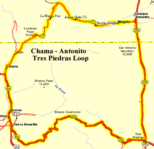
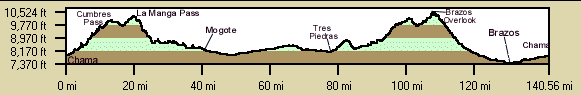
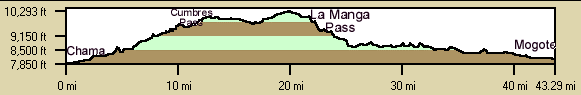
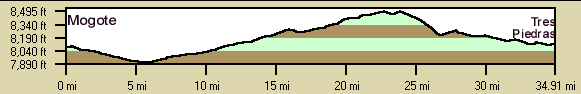
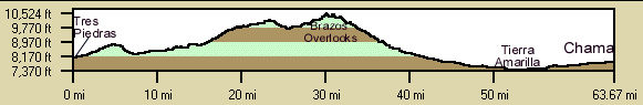
The route from Chama to Mogote climbs Cumbres Pass (10,015) and La Manga Pass (10,230') which are only moderate climbs. You can even race the train up to Cumbres Pass from Chama. The route follows the scenic Conejos River to Mogote, west of Antonito, CO. The route then turns south on US285 to Tres Piedras passing San Antonio Mountain where there is often antelope grazing. The route then turns east climbing to terrific views of the Brazos Cliffs before a swift descent to Tierra Amarilla. The ride north to Chama completes the loop. Take water and food along and be prepared for storms.

Roadways: Most of the roadways have light traffic except for US285 from Antonito to Tres Piedras. US285 from Antonito to Tres Piedras has moderate fast traffic but has shoulders except the last 8 miles to Tres Piedras. US84 from Tres Piedras to Tierra Amarilla has light traffic and is very scenic, an ideal touring roadway. US64 from Tierra Amarilla to Chama has moderate traffic at times but has shoulders most of the way. NM17 & CO17 have light traffic.

Getting There: Start in Chama, however, since it is a loop the ride can start at any point on the loop. There are a number of motels and B&B's where you can start and finish at.

Distance: 140 Miles, 8,800 Ft. Elevation Gain (3 days). This is a moderate ride. The climbs and descents of Cumbres and La Manga Passes are moderate, nothing too extreme, see the elevation profiles below.

Options:

  • A two day option is to ride from Chama to Mogote, spend the night, then return to Chama. This misses the scenic section on US64, though. 40 Miles each way 2500' climbing Mogote to Chama, just one steep stretch going up La Manga Pass but in itself is a great ride.
  • Ride from Chama to the summit La Managa Pass and back. This a ~42 mile ride depending on where you turn around but a great ride. The descent is real pretty.

Notes: Chama has a grocery store on the south end of town. There is a restaurant at the east side of La Manga Pass after the descent. The route comes near Antonito, CO but does not enter the town. There are motels and grocery stores in Antonito. There is a cafe in Tres Piedras but that is about all. There are no supplies from the Running Elk to Tierra Amarilla on US64.


Chama - Antonito - Tres Piedras Three-Day Loop Cuesheet // 140 miles, 8800' Elevation Gain
Mileage Waypoint Description
Day 1: Chama to Broyles Bridge: 42 Miles, 3,600 ft. Climbing.

0

Chama supermarket Ride north on NM17 through downtown Chama. The Cumbres & Toltec Scenic Railroad begins at the north end of Chama. There are some nice viewpoints where the railroad passes below your vantage point. Keep on the lookout for wildlife such as wild turkeys.

9.25

NM/CO Border Continue North on CO17.

13.6

Cumbres Pass (10,015') Continue on CO17. Descend following the Conejos River.

21

La Manga Pass (10,230') Continue north and east on CO17. There is a restaurant at the east side of La Manga Pass.

26.25

Elk Creek campground Continue east on CO17.

33.3

Aspen Glade CG Continue east on CO17.

38.5

Broyles Bridge The Conejos River Home Hostel is located about 100 yards to the right just on the other side of the Conejos River. Turn right on the D-5 road, cross the Conejos river, the hostel is the group of several small green buildings.
Day 2: Broyles Bridge to Tres Piedras: ~48 miles, 1,600 ft. Climbing.

0

Broyles Bridge Start at the hostel, ride east on CO17.

5.5

Mogote Continue east on CO17. There is lodging available here, too.

10

JCT with US285 Turn south on US285. Antonito,CO is just east US285. Lodging and groceries are available there. The The Cumbres & Toltec Scenic Railroad terminal is at this intersection. Watch for antelope along the highway.

15.3

NM/CO Border Continue S on US285.

40

Tres Piedras
Jct of US64 and US285
Turn west on US64. There is a cafe at the intersection open for breakfast and lunch.

48

Mile Marker 215 The Running Elk Lodge on the left.
Day 3: Mile Marker 215 to Chama: ~52 Miles, 3,200 ft. Climbing - Overlooks of Brazos valley.

0

Running Elk Lodge Ride west on US64

40.7

Jct US84 Turn North on US84/64. Shoulder most of the way that is rough in spots. The highway surface is worse.

40.9

JCT NM531 - Tierra Amarilla Continue North on US64. There are a couple of gas stations and maybe a cafe to get snacks or drinks just past the intersection.

42.8

Fish Hatchery Continue north on US64

43.3

NM95 - Herron Lake Continue north on US64

53.7

Jct NM84/NM17 in Chama Continue north on NM17. Gas station and Dairy Queen at the intersection to get snacks or drinks.

55

Chama supermarket  

Chama - Antonio - Tres Piedras Loop Route Map

Route Map

Chama - Antonito - Tres Piedras Elevation Profile

8,800 ft. elevation gain.
Chama - Mogote -
Tres Piedras - Chama
Loop Profile
Trip Profile
Day 1 Profile:
Chama - Mogote
Day 1 Profile
Day 2 Profile:
Mogote - Tres Piedras
Day 2 Profile
Day3 Profile:
Tres Piedras - Chama
Day 3 Profile