|
 |
|
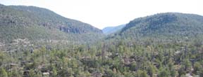
Gila National Forest
|
The classic Gila Inner Loop Tour traditionally begins and ends
at Silver City WalMart. The Gila Inner Loop is one of the favorite
tours in New Mexico. It has light to no traffic and has stupendous
views. The best times of the year are spring and fall to avoid the
heat. There are moderate but not extreme climbs. The loop itself is
doable in a single long hard day. A favorite option is the challenging
descent and climb out of the Gila Cliff Dwellings National Monument. Just east
of the route, on the way to Kingston and Hillsboro, the Emory Pass Option climbs through the Black
Range, another favorite route.
Getting There: Silver City is about a 5 hour drive
southwest from Albuquerque, through Kingston and Hilsboro, or through
Deming and north west of Las Cruces and El Paso. NM152 through the
Black range is a fairly slow drive but has terrific scenery. It is
about the same time as going through Hatch. The Gila Wilderness and the
Black Range are north of Silver City. The tour can start pretty much
anywhere in Silver City.
Distance: 88 miles, 5,400 ft. elevation gain.
Roadways: NM15 and NM35 are two lane, rural roads
without shoulders, light to no traffic, with reasonable surfaces. NM152
is divided 4-lanes with shoulders with light, fast traffic. Watch for
lots of debris on the shoulders. US180 is divided 4-lanes with
shoulders and moderate, fast traffic. Watch for debris on the shoulders.
 |
|
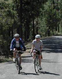
Happy Gila Riders
|
Options:
- Day 1: Anderson Overlook from the intersection of NM15
& NM35 - 17 miles roundtrip, an additional 1,500' of elevation
gain, almost all uphill in, downhill out. A popular extension to the
basic loop. This makes day one pretty hard.
- Day 1: Gila Cliff Dwellings
Out and Back - for the hardcore.
- Day 2: Get an early start. From Camp Thunderbird, ride
the Mimbres valley to the intersection of NM35 and US152 but turn left (east)
on US152 and ride over Emory Pass to
Hillsboro and have someone driving home pick up your gear, then pick
you up in Hilsboro. It's often with the wind and a beautiful ride. 48
miles from Camp Thunderbird to Hillsboro. Eat lunch in Hillsboro.
- Day 2: From Camp Thunderbird, ride the same route back on
NM35 west to NM15, through Pinos Altos and downhill to Silver City.
Same distance, about 3,400' elevation climb. In the morning light the
valley is very pretty. Avoid the wind on NM152. But it is longer than
the standard route.
- Emory Pass Ride
- There is a lot of mountain biking in the area of Ft.
Bayard east of Silver City and Signal Peak near Pinos
Altos. There are books on the area and maps at the National Forest
Ranger station.
- Another road option is riding west from Silver City to
Cliff and back.
- Another possibility is to get dropped off in Glenwood and
ride the pleasant 62 miles of rolling hills, mostly downhill, to Silver
City.
Notes: The Silver City KOA is one of the best. The
winds always seem to be blowing out of the west along NM152 & US180
in the afternoons, so get an early start.
Route Map
Elevation Profile
Map at Bikely.com
Options Map
Emory Pass Ride Option
USFS
Gila National Forest
Gila National Forest Mountain Biking
US NPS
Gila Cliff Dwellings National Monument
Bathrooms - There are toilets at the Cherry Creek
Campground, the Lake Roberts Store, the first Gila Cliff Dwellings
Overlook, and a Lake Roberts pullout.
|