| Mileage |
Waypoint |
Leg Description |
|
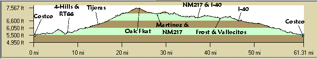
0
|
Southern & Eubank |
Start and End. Ride east on Southern to Juan Tabo. |
|
1.1
|
Juan Tabo |
Turn right (south) on Juan Tabo. |
|
1.4
|
Singing Arrow |
Turn left (east) through the trailer park. Continue straight through 3 stop
signs on Singing Arrow to the Singing Arrow Center. |
|
2.2
|
Bike path |
Bear right on the bike path at the Singing Arrow Center to Rachel. Take Rachel
left steeply downhill. Don't turn left on the bikepath. That takes you uphill to the Burger King and Tramway. |
|
2.6
|
Four Hills |
Turn right (south) - Four Hills Lollipop Loop. Downhill. |
|
3.2
|
Stagecoach |
4-Hills Loop: Turn right (west) and ride to the top of the hill. Stagecoach
turns into Wagon Train going south then east. Then it turns into La Cabra Dr. |
|
5.6
|
Pedregoso Ct |
Turn left. Ouch! & "No Outlet". |
|
5.8
|
Stagecoach |
Turn left. |
|
6.4
|
Stagecoach |
Turn left. Hideaway yield. |
|
6.9
|
Four Hills |
Turn right (north). Steep climb to RT66. |
|
7.8
|
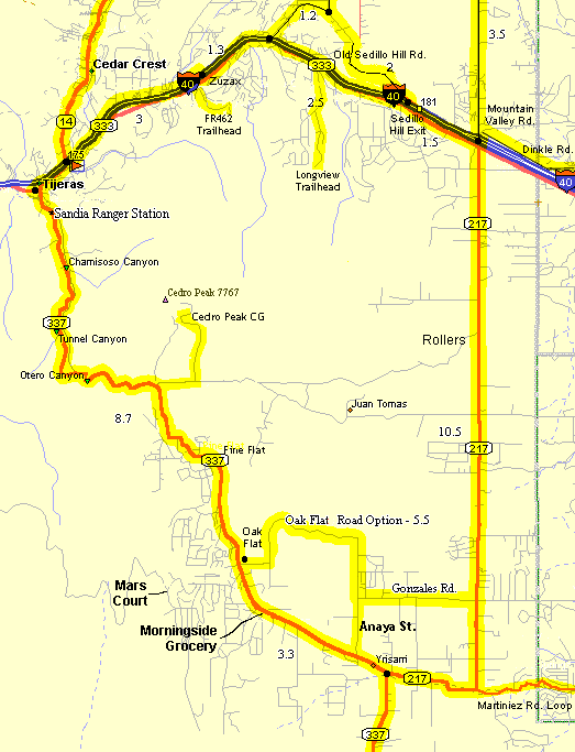
Old Rt66 |
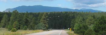
Turn right (east) on RT66, head up Tijeras
Canyon. Who ordered up
the hills? |
|
14.5
|
Tijeras traffic light |
Rest Stop; 24 Mile Turn
Around. Remainder turn right (south) ride up NM337 (old S - NM14). See Oak Flat write up. Very picturesque stretch. |
|
24.3
|
Morning Star Grocery |
Rest Stop; 44 Mile Turn
Around. Remainder continues south on NM337. Nice descent. |
|
26.5
|
NM217 |
Turn left (east) on NM217. More downhill. |
|
28.2
|
NM217 & Martinez Rd. |
Turn left (south) at the intersection and continue on the NM217
"Rollers". You'll realize what this means. At least this is
the more downhill direction. |
|
37.2
|
Rt-66 / I-40 / Mountain Valley Rd. |
Rest Stop. Continue straight
across NM333 (Historic RT66), I-40, and onto Mountain Valley Rd. Enjoy the new AASHTO shoulders. |
|
40.9
|
Frost Rd. |
Turn left (west) towards the mountains. Are
your legs burning? |
|
43
|
Vallecitos |
Turn left (south) and start climbing. Enjoy the great view of the mountains. |
|
43.9
|
Meadow |
Turn right (west) at the stop sign, a nice fast descent. Curves south then
uphill. |
|
44.9
|
Old Sedillo Hill Rd |
Turn right (west) and curve left (south) downhull through a picturesque canyon
and under I-40. |
|
46.1
|
NM333 |
Right (west) on NM333 (Historic RT66) and enjoy the descent to Zuzax. |
|
47.5
|
Zuzax |
Right (north) over I-40 and left on the north frontage road, N. Zamora Rd.,
which is more pleasant than the south. Goes under I-40 to NM333. |
|
49.7
|
NM333 |
Turn right (west) and ride a short way to the traffic light at NM14. |
|
50.5
|
NM14 |
Turn left (west) on NM14, ride downhill a short way to Tijeras, pass through
the traffic light to the library. |
|
51.2
|
Tijeras Library |
Rest Stop. Almost home!
Continue west on now NM333. |
|
57.8
|
Four Hills Rd. traffic light |
Turn left (south) at the light, sharply downhill. |
|
58.1
|
Rachel |
Turn right (west), back to Singing Arrow to Juan Tabo again. |
|
59.3
|
Juan Tabo |
Turn right (north) on Juan Tabo. |
|
59.6
|
Southern |
Turn left (west) on Southern. |
|
60.7
|
Costco |
Whew. Great Job! |