Click on a section of the map for more detail.
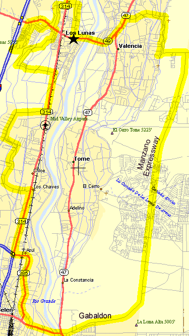
The El Tour de Valencia takes the rider through some very scenic areas of the Rio Communities south of Albuquerque. The countryside is pure New Mexico pastoral, with horses grazing in cultivated fields fed by ancient acequias, or irrigation ditches.
The ride is on mainly 2 line roads with no shoulders with light to moderate traffic. The tour tries to avoid highways like NM47 or NM314 with heavy traffic but does get on them occasionally. The ride is pretty flat and best done in the spring or fall to avoid the afternoon heat in the valley. The small hills on the Manzano Expressway give a good view of the valley and Tome Hill.
Thanks to Tom Sanderson for developing this tour.
Getting there: Take I-25 south from Albuquerque to the Los Lunas Exit 203 on NM6. Take NM6 east 2 miles to the closed Furrs store at Los Lentes Rd. in Los Lunas.
Distance: 44 Miles, 600' Elevation Gain
Options: See the el Tour de Valencia II 60 Mile Option below.
See the Tour de Valencia III.
el Tour de Valencia CueSheet // 44 Miles, 600' Elevation Gain
Tour
MileageWaypoint Leg Description Leg
Mileage0
Parking Lot at NM6/Los Lentes Rd. Ride North on Los Lentes Rd. 1.2
1.3
Trujillo St. Turn left (west). .4
1.7
Highway 314 Turn left (south) towards Los Lunas .1
1.9
Tondre Rd. Turn right (west) on Tondre Rd. .35
2.25.
Don Pasqual Stop Light Turn left (south) on Don Pasqual, ride to NM6 .8
3
NM6 Turn Right (west) on NM6 to Camelot 1
4
NM6/Camelot Stop Light. Shamrock Station Turn Left (south) on Camelot. Follow Camelot to Vista Hill Loop. 1
5
Vista Hill North Loop/Camelot. Bus Stop Sign Turn Right (west). This loop curves left (south) then curves left again (east) back to Camelot. Pass the stop sign to Crestview. .5
5.5
Crestview Left (north) on Crestview .6
6
Hillside Left (west) on Hillside .1
6
Grant Right (north) on Grant Blvd to Rio Grande Blvd .5
6.5
Rio Grande Blvd. Right (east) on Rio Grande Blvd .4
7.1
Adela Left (north) on Adela Ln to NM6 .35
7.3
NM6 Right (east) on NM6 to Sichler Dr. .15
7.6
Sichler Dr. Right (south) on Sichler Dr. to Morris stop sign. Law Office at this corner. 2
9.5
Morris Stop Sign Straight on Morris curves to east now to NM314 passing one stop sign 1.4
11.1
NM314 Turn right (south) towards Belen to Miller Rd. 1.4
12.6
Miller Rd / NM314 Turn right (west) on Miller Rd.at NMSU Research to Peyton Rd. At 1.1 Miller Rd. curves left (south) 2.1
14.7
Peyton (Running Horse) Left (east) on Peyton Rd to Sebell .5
15
Sebell Right (south) on Sebell to Square Deal 1.5
16.9
Square Deal Left (east) on Square Deal to NM314 1.0
17.9
NM314/Square Deal Right (south) on NM314 towards Belen. Just past Joe Sanchez on the left is the frontage Rd. just before Gabaldon Rd. Take the frontage road to Gabaldon 2.4
20
NM314 Frontage Rd/Gabaldon Left (east) on Gabaldon which curves right (sourth) towards Belen. Gabaldon has stop signs at Padilla, Aragon, and Sunshine. Stay on Gabaldon. 3.15
23.5
NM309 (East River Rd) / Gabaldon Left (east) on NM309. Cross the Rio Grande to NM47 1.2
24.7
NM47 Stop light / Manzano Expressway There is a mini mart on NM47 south of this intersection. Continue straight (east) through the traffic light. The highway becomes the Manzano Expressway here at the Rio Communities. The Manzano Expressway curves left (north) to Van Camp Blvd. stop sign.
There are a few rolling hills along here.
The Manzano Expressway has pretty light traffic, no shoulders and runs along the east side of the towns. Good views of Tome Hill.9.8
34.5
Manzano Expressway Continue North on Manzano Expressway 2.4
37
Meadowlake Rd. Turn left (west) at the stop sign. Downhill to the light.
Option: Turn right and ride east (up) Meadowlake as far as you want and return the same way.1.0
38.5
Ladera Rd / NM263 Stoplight Turn right (north) 1.5
40
Valencia Rd Stop Sign Turn left (west) to NM47. No street name sign but is the first stop sign.
There are two stop signs on Valencia before NM47 which is a major highway.1.5
41.5
NM47 Stoplight Turn left (south) toward Los Lunas .6
42.1
NM6 "Y" Keep to the right (west) on NM6. Cross the Rio Grande. Use sidewalk if desired. NM47 keeps going south. 2.3
44.5
Los Lentes Road and the start point!
Click on a section of the map for more detail.
| El Tour de Valencia II 60 Mile Option |
The el Tour de Valencia II 60 Mile Option rides through the villages of the Rio Abajo, the middle Rio Grande Valley region, south of Albuquerque. The route covers portions of New Mexico's royal road (El Camino Real de Tierra Adentro) in the Tome/Adelino area. Portions of the route were traveled by Francisco Coronado in 1540. The ride regroups at Tome Hill's massive sculpture, La Puerta del Sol, celebrating the three cultures of this region: Indian, Spanish, and early European settlers. The Tome Hill settlement was established in 1661 and petroglyphs on Tome Hill are over 2,000 years old. The countryside is pure New Mexico pastoral, with horses grazing in cultivated fields fed by ancient acequias, or irrigation ditches.
The el Tour de Valencia II starts on the same route as above, with additional pavement and loops to add more miles. The route goes north through Los Lentes and then west to I-25. The first segment tours newer homes, built near I-25, and circles the area around Los Lunas High School. At this point, there is a close up view of El Cerro Los Lunas and a great view of the valley and Tome Hill below. Next, is a descent east toward the river and then south to the perimeter of the NM Minimum Security Prison. Instead of heading toward Belen, the route continues east through Los Lunas to Highway 6, and then across the Rio Grande to the Valencia Y. At Valencia, head south on Highway 47 to the end of the four lane and paved shoulder (1.5 miles south of Chocolates, Etc.) The route turns east on Otero Rd. to El Cerro Loop. A short distance on the loop to a fork left that goes to Tome Hill. The route meanders through the hills around UNM Valencia and the Pasitos and Las Maravillas sub-divisions. The route continues north on the Manzano Expressway and then east toward the Manzano Mountains, just south of Meadowlake. At the east end of good pavement, the route loops back with a downhill ride to Tome. The return covers more roads around UNM Valencia, Tome Hill, Valencia, and Peralta, then back to the start.If desired, shortcuts are available and an optional route extension to the Belen area, can be added.
Distance: 60 miles, pretty Flat.
Getting there: Take I-25 south from Albuquerque to the Los Lunas Exit 203 on NM6. Take NM6 east 2 miles to the closed Furrs store at Los Lentes Rd. in Los Lunas.
Notes: Hang onto the cuesheet below, it's pretty complicated.
El Tour de Valencia II CueSheet (Note that there are two Columns)
ElTour de Valencia II CueSheet // 61 Miles
Tour
MileWaypoint Leg Description Leg
Mile0 Parking Lot Highway 6 & Los Lentes (701 Main) Ride North on Los Lentes Rd. 1.2 1.2 Trujillo St Turn left (West) just before the San Antonio Church 0.49 1.69 Highway 314 Turn right (North) toward Albuquerque 0.89 2.58 Griego (Cottonwood de Isleta Turn Turn right (East) at last turn before reservation boundary .27 South on Los Lentes 0.9 3.75 Trujillo St (again) Turn right (West) just after San Antonio Church 0.43 4.18 Highway 314 Turn left (South) toward Los Lunas 0.13 4.31 Tondre Road Turn right (West) through tree lined road .35 4.66 Don Pasqual Turn left (South) at stop sign 0.83 5.49 Highway 6 Turn right (West) at stoplight and go up the hill .62 6.11 Los Cerritos Turn right (North) before the high school 0.86 6.97 Emilio Lopez Turn left (South) just before the small park. (Los Cerritos Park) 0.98 7.95 Texico & Wendys Regroup just before crossing NM Highway 6 0.12 8.07 Highway 6 Go across Highway 6 (South) to Camelot (by the Shamrock station) 0.89 8.96 Vista Hill North. (Bus Stop Turn right (West) for view of El Cerro Los Lunas 0.52 Continue on loop to stop sign at Camelot (East) (9.39)
The next left is a short distance9.48 Crestview Turn left (North) at the 1st left after Camelot 0.52 10 Hillside Turn right at the stop sign (East) The next right is a short distance. .1 Valley View .5 10.59 Crestview (Again) Turn right (North) .51 11.11 Hillside (again) Turn left (West) at the stop sign. Hillside curves right to Grant Blvd (North) .04 11.15 Grant Blvd Continue North, the next right turn is the last turn before downhill to Chevron station at Highway 6 0.46 11.61 Rio Grande Turn right (East) for a very short uphill followed by longer downhill then curve north to Canal. Watch for traffic at bottom of hill. 0.53 12.14 Adela Ln Yield then turn right (East), then curve left (North) 0.2 12.34 Highway 6 Turn right (East) at the stop sign 0.28 12.62 Sichler Dr. Turn right (South) by 30MPH and Law Office signs. Continue following the best pavement 2.12 14.74 Morris/Prison Entrance Continue on Morris (East) at the stop sign 1.34 16.08 Highway 314 Regroup at the stop sign Morris Continues across 314 (East). Be careful crossing 314 0.13 16.21 Los Lentes Turn left (North) 0.87 17.08 Aspen Turn right (East) after First Baptist Church 0.1 17.18 Carson Drive Turn left (North) .71 17.89 Highway 6 Turn right (East) at the stoplight after RAKS and the Post Office 0.99 Cross river (bridge pavement is bad) Sidewalk option: Sidewalk Hazard after bridge 18.88 Lujan Turn right (East) after bank at Ribs sign 0.28 19.16 Highway 47 Turn right (South) 0.11 19.27 Chocolates Etc. Regroup 1.48 20.75 Otero Turn left (East) Just before Valley Lutheran Pre-School and before 4-lane ends 1.42 22.17 El Cerro Loop (No Sign) Turn right (South) (ATW sign in front, Cottonwood tree to left) Be careful, fast traffic 0.27 22.44 Sandhill (No Sign) Y left (South) after 2/10 mile on El Cerro Loop. Be careful, fast traffic on El Cerro Loop 1.51
Tour
MileWaypoint Leg Description Leg
Mile23.95 ? (No Sign) Turn right (West) at the hill top stop sign (Tome Hill) .3 24.25 La Entrada Turn left (South) regroup at sculpture. Continue on La Entrada past 1/10 mile of sandy dirt road .7 24.95 Romero Turn right (West) and continue to intersection of 47 & Patricio 1.37 27.6 La Entrada Turn left (North) at the stop sign near the Pasitos Sign. Continue on La Entrada past next stop sign and go past UNM Valencia .5 28.1 Chacon Turn right (East) .55 28.65 De Hann Loop Turn right (South), continue to T intersection .68 29.33 Rio Del Oro? (no sign Turn Left (East) 1.18 30.51 Manzano Expressway Turn left (North) (Dangerous, Fast Traffic coming over hill) 0.4 30.91 Las Maravillas Entrance Turn right (East) into sub division 0.07 30.98 Marigold Turn left (North) and continue through sub division 1.09 32.07 Camino la Canada (No Sign Turn Left (West) 0.23 32.3 Manzano Expressway (No Sign) Turn right (North) (Dangerous - Fast traffic) 1.96 34.26 Van Camp Turn right (East) continue on Van Camp (North) 1.81 36.07 Winston Drive Turn right (East) 1. 37.07 Santa Monica?(No Sign) Turn left (North) before utility boxes & small white buildings .29 37.36 El Cerro Mission (No Sign) Turn left (West), continue to left turn past Manna Mart 1.01 38.37 Van Camp Turn left (South) (Airport Rd is to right) 2.06 40.43 Manzano Expressway (No Sign) No turn (West) Manzano traffic has stop sign. Continue on Van Camp and curve right (North) .6 41.03 El Cerro Mission Turn right (East). Regroup at Conoco/R&D Quickstop 0.27 41.3 Manzano Expressway (Dangerous - Fast traffic)
Note: Watch for the new bike path on West side of the Manzano Expressway3.85 45.15 Rio del Oro? (No sign) Turn right (West) just past Las Maravillas (Long downhill) 2.01 47.16 La Entrada Turn right (North) 0.43 47.59 Patricio (No Sign) Turn left (West) 1.31 48.9 Highway 47 Be careful crossing 47. Regroup @ Tome Church/Park .64 49.54 Highway 47 Turn North (Dangerous for 1/2 mile) 0.35 49.89 Entrada Aragon Turn right just before Post Office 1.42 51.31 La Entrada Go North toward Tome Hill 0.35 51.66 ? (No Sign) Turn right (East) at Tome Hill 0.32 51.98 Sandhill (No Sign) Turn left (North) just past Tome Hill 1.52 53.5 El Cerro Loop (No Sign) Merge (North) for 2/10 Mile, Be careful 0.25 53.75 Otero (No sign) Turn at first left (West) before cottonwood tree 1.42 55.17 Highway 47 (No Sign) Turn right 1.37 56.54 Vegas Rd Turn right (East) (2nd road after stoplight and before Chocolates Etc.) 0.92 57.46 Molina (No Sign) Turn left (North) 0.74 58.2 Valencia Rd (No Sign) Turn left (South) at Stoplight 0.39 58.59 Highway 47 No turn go straight (South) to Highway 6 at intersection 2.31 60.9 Highway 6 Continue over river (West), past Burritos Allinstante to start. Sidewalk option, bridge pavement is bad. Turn left (South) into Village Inn/Furrs just before Los Lentes. Hurrah! You Found Your way back - Extra points for not getting Lost