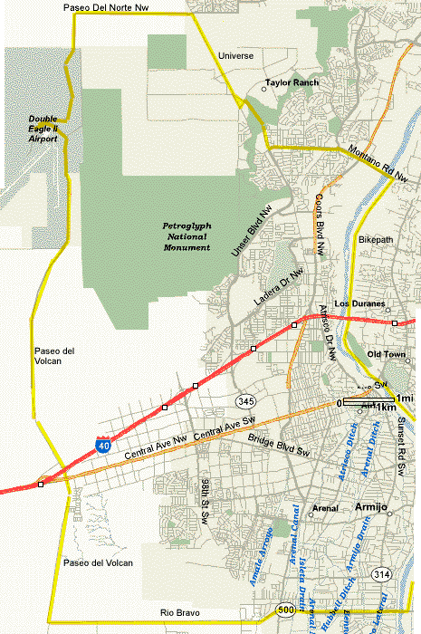
Double Eagle Dash


The scenic Double Eagle Dash Loop begins and ends at the Albuquerque Bio Park. This is a good winter ride. The ride takes you high on the west mesa where there are great views of the Sandias, Manzanos, Jemez Mountains, and Mt. Taylor. These may be snow capped in the winter and are a terrific contrast in colors. You pass the Albuquerque volcanos. Some rides stop at the Double Eagle Airport Prop Wash snack bar for lunch or a snack.

   Double Eagle Dash
 

Double Eagle Dash Route

Part of the ride uses the hugely popular Bosque / Riverside Bikepath. The southern part of the bikepath is not nearly as busy as the northern section. The bikepath follows the Rio Grande diversion channel and is exceptionally nice in the morning. Itand is exceptionally pleasant. The bikepath is noteable in that there are no at-grade street crossings for its entire 16 mile length.

Universe Rd. is a new road from the end of Unser north of Montaño at the top of the mesa to the stop sign at Paradise Hills Rd. at the east end of the La Ventana addition. This road is 2-lanes (no shoulders naturally) but with a speed limit of 35 (ha ha).

Thanks to Dorothy for developing this ride.

Getting There: This ride begins and ends at the Albuquerque BioPark at Central Ave. and the Bosque Bikepath and the Rio Grande.

Distance: 39 Miles moderate hills.


Roads: All the roads outside of town have light traffic. Paseo del Volcan has shoulders and very light traffic. Universe has no shoulders but very little traffic.

Options:

Notes: A lot of the ride is on the west mesa where there are few places to get water. Carry ample supplies in the summer.

  • There are restrooms and food at the Prop Wash Cafe in the second floor of the West Mesa Aviation building at Double Eagle Airport.
  • There are convienence stores at I-40 & Central & Paseo del Volcan.
  • USNPS Petroglyph National Monument.
 
Double Eagle Dash Plus CueSheet // 46 Miles
Mileage Waypoint Description

0

Bio Park Ride south on the Bosque/Riverside Bikepath, on the west side of the Bio Park parking lot to Rio Bravo.

5.5

Rio Bravo Blvd. Underpass Turn left (east) on Poco Loco (north side of Rio Bravo). Rio Bravo is above, ride east on the north side access road until Rio Bravo drops down to ground level (.1 miles).

5.6

Rio Bravo access Sharp right (U-Turn west) on Rio Bravo, climb the bridge, cross the Riverside / Bosque Bikepath and the Rio Grande. Watch for debris on the bridge. The bridge has shoulders but has lots of trash.

8.5

Coors Blvd. Continue straight (west) on Rio Bravo, climb the new pavement (shoulders) to the top of the hill. Great views of Albuquerque!

13.5

Paseo de Volcan Turn right (north) on Paseo del Volcan to the stop at Central Ave. Continue straight across (north) Central on Paseo Volcan which climbs a bridge over I-40.

15.5

I-40 Bridge Continue straight (north) on Paseo del Volcan. This climbs slightly but there is nice pavement, little traffic and super views of the Sandias. You're in the middle of nowhere here. Nice stretch. You pass the volcanos that are part of the Petroglyph National Monument and its east trailhead about 4.8 miles north of I-40.

23

Double Eagle Airport Turn left to Double Eagle Airport (elev. 5,834' ). There are restrooms and food at the Prop Wash Cafe in the second floor of the West Mesa Aviation building. This is a small general aviation airport so the turn is obvious.

46

BioPark Return by the same route..

Double Eagle Dash CueSheet // 39 Miles
Mileage Waypoint Description

0

Bio Park Ride south on the Bosque/Riverside Bikepath, on the west side of the Bio Park parking lot to Rio Bravo.

5.5

Rio Bravo Blvd. Underpass Turn left (east) on Poco Loco (north side of Rio Bravo). Rio Bravo is above, ride east on the north side access road until Rio Bravo drops down to ground level (.1 miles).

5.6

Rio Bravo access Sharp right (U-Turn west) on Rio Bravo, climb the bridge, cross the Riverside / Bosque Bikepath and the Rio Grande. Watch for debris on the bridge. The bridge has shoulders but has lots of trash.

8.5

Coors Blvd. Continue straight (west) on Rio Bravo, climb the new pavement (shoulders) to the top of the hill. Great views of Albuquerque!

13.5

Paseo de Volcan Turn right (north) on Paseo del Volcan to the stop at Central Ave. Continue straight across (north) Central on Paseo Volcan which climbs a bridge over I-40.

15.5

I-40 Bridge Continue straight (north) on Paseo del Volcan. This climbs slightly but there is nice pavement, little traffic and super views of the Sandias. You're in the middle of nowhere here. Nice stretch. You pass the volcanos that are part of the Petroglyph National Monument and its east trailhead about 4.8 miles north of I-40.

23

Double Eagle Airport Turn left to Double Eagle Airport (elev. 5,834' ). There are restrooms and food at the Prop Wash Cafe in the second floor of the West Mesa Aviation building. This is a small general aviation airport so the turn is obvious.

23.2

Double Eagle Airport Turn right at the stop sign, ride east a little, then curve to the north for several miles. Don't ride back the way you came. The road then curves to the right (east), just follow the road, it's the only pavement out there, and you head back toward the city. This is a barren section with great views in all directions with no shoulders but no traffic.

29

Universe Turn right (southeast) on Universe to the stop sign at the top of Boca Negra Canyon at Unser. This new section has no shoulders but light traffic.

31

Unser Turn left (easterly) on Unser and go screaming downhill off the west mesa past the Boca Negra Canyon picnic area of the Petroglyph National Monument to the stop sign at Montaño.

32

Montaño Turn left (east) on Montaño.

34

Rio Grande Continue straight (east) on Montaño over the Rio Grande.

34.5

Bosque Bikepath Turn right (south) on the bikepath, pass the Nature Park, Campell Rd. exits.

38.2

I-40 Continue south on the bikepath under I-40, and pass the Mountain Rd. exit.

38.7

BioPark Turn left into the parking lot to the BioPark just before Central Avenue. Great ride.