|
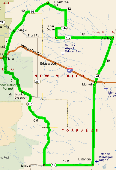
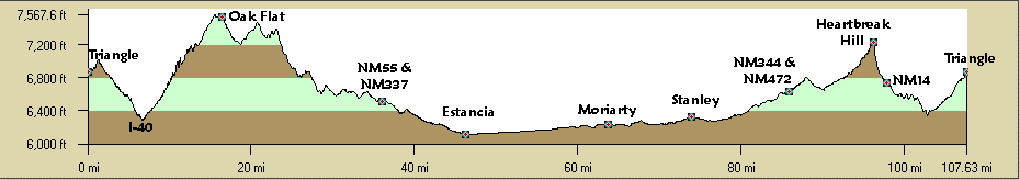
Starting at about the "Triangle", the intersection of NM14, Frost Road, and the Sandia Crest Road, ride south paralleling the Sandia Mountains, climb Mailbox Hill, then it's a fast downhill to I-40. Be alert for gravel in the road from a side gravel road near the motorcycle shop. Cross under I-40, pass the stop light, follow the main highway right about 1/2 mile to the Tijeras stop light at NM337, and turn left. Climb south on NM337 passing the Sandia Ranger Station, and Pine Flat and Oak Flat USFS picnic grounds. See the Oak Flat ride. This section climbs through ponderosa, juniper, and cedar forest through some striking road cuts. Note the mountain bike trailheads as you climb. Just past (south) of the USFS Oak Flat Picnic Ground is the Morning Side convenience store, the only store until Estancia. Crest the ridge then it's downhill to NM217, continue straight (south) on NM337. Continue south on NM337 climbing on rough pavement followed by some fast downhills. There are great views of the Manzano Mountains and glimpses of the Estancia dry lakes to the southeast. Here you're passing through mainly juniper and cedar forests. You pass through the small towns of Chilili and Escoboso. The road rolls on to the intersection with NM55. The small town of Tajique is about 3 miles to the west of the NM337/NM55 intersection (out of the way) but it has a small store. See the Tajique Tango ride. The turn at NM55 is at a stop sign and obvious. Turning east on NM55 the road rolls down to Estancia and opens up with grasslands on both sides of the road providing wide views in all directions. The road stays pretty open until the climb up Heartbreak Hill (the easy side). Watch for hawks and the rare eagle on the telephone poles, they won't attack unless you collapse. In Estancia (pop 1574) turn left (north) at the obvious stop sign on NM41. You pass two convenience stores and a grocery store. NM41 north of Estancia has great shoulders and is almost flat to Moriarty. Moriarty is about 64 miles into the loop, a good time for food since there isn't anything until the "Triangle". The road is wide open with view of the mountains to the west. Continue north through several traffic lights in Moriarty to old RT66. There are several gas stations, fast food, and motels mainly to the west on NM333. Continue north on NM41over I-40 to Stanley. You could bail here and take old Rt66 west to Tijeras but the traffic in Edgewood is ugly. There really isn't anything of note at Stanley, turn left (west) on NM472. This road rolls somewhat uphill through open rural terrain with the Sandia Mountains looming in front of you. There is a stop sign at the intersection with NM344 and Mountain View Elementary. This turns into Frost Road which continues on to NM14 if you need to bail out. Turn right (north) on NM344. Edgewood is about 8 miles south, the opposite direction. Ride towards South Mountain to Cedar Grove. The road curves east then north. Just follow the pavement, all the other roads are gravel. Traveling north you head towards the Ortiz Mountains and its gold mines. The road curves west into forest again and you begin climbing towards (insert the movie Jaws music here) Heartbreak Hill. Actually, the climb in the west direction is not that hard. You will see the ridge line you need to cross as you climb. There is space to pull off on the summit and enjoy the view and check out the descent. Be careful on the descent, it's pretty steep. Early in the year there is sand left over from the winter snow sandings. You roar downhill east through San Pedro to the intersection with NM14. Stop and admire the view. Turn left (south) on NM14. The route rolls mainly down through some forested hills to the San Pedro stream and housing addition. There are great views of the south Sandia Mountains and the ski area is obvious. There are no shoulders on this section of NM14 and there's a bit more traffic but it's not heavy. There's a large pueblo on the right at Paccao on State land. From San Pedro there are a couple miles of easy climbing to the "Triangle". Congratulations, you made it, tough ride. Being a loop this ride can start and end at any point. Reversing the route includes Heartbreak Hill the hard way and the climb from I-40 from Tijeras to Mailbox Hill. Distance: ~108 miles, ~7000 ft. elevation gain. Getting There: The "Triangle" is on NM14 about 7 miles north of I-40 at the intersection of NM14, Frost Road, and the Sandia Crest Road. Since this is a loop, the ride can be started and ended at any point. Options: Lots.
Roadways: All roads are paved. Estancia to Stanley and the Triangle to NM217 on NM337 have shoulders, the climb up NM337 is nice. All traffic is pretty light except NM14 and NM41 around Moriarty but NM41 has shoulders and north NM14 isn't normally a problem on weekends. Watch for gravel at an intersection on NM14 in Cedar Crest by the motorcycle shop since this is downhill. Notes: Get an early start since it can get really windy in the spring. Winter hangs on early in the year. Late September and early October can be wonderful months. Summer afternoon thunderstorms can pop up too, be prepared.
|
||||||||||||||||||||||||||||||||||||||||||||
|
||||||||||||||||||||||||||||||||||||||||||||