Cedro Peak Area Mountain Bike Trails


Cedro Ridge

Pedaling West on Cedro Ridge

The Cedro Peak Mountain Bike Trails are comprised of a network of intermediate to hard single and double track trails in the east Sandia Mountains, a part of the Cibola National Forest. The area is comprised of arid, hilly, mixed juniper, pinion and ponderosa forests. The trails have expansive views of the Sandia Mountains to the north, the Manzanos and the Cedro Peak. Some of the descents are tricky due to the loose rocky stretches so know your skill level.

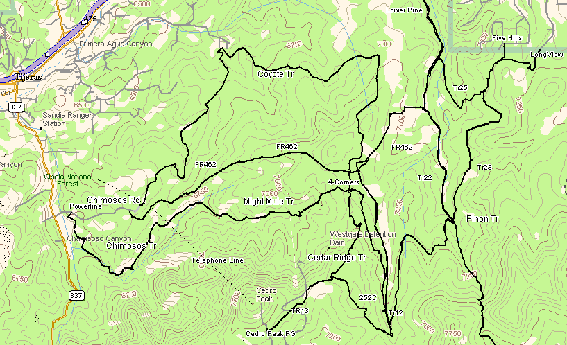
A major resource is The Trails of Cedro Peak & Otero Canyon ($7) available from the Sandia Ranger Station or local bicycle shops. There are many alternate trails that are not found on the map so good map and terrain reading skills are necessary.

Much thanks has to go to Trail Partners who have done a lot of trail building and maintenance, also to the US Forest Service for supporting the recreational use of this area, so close to a major metropolitan area.

Many new trail markers have been added recently which help greatly navigating the numerous trails.

Don't ride alone.

Take along more water than you think you'll need. The only water available in the area is at the Cedro Peak Campground and at the USFS Ranger Station in Tijeras.

There are a lot of intersecting and unofficial trails that branch off making it confusing and easy to get lost. Take a map and plenty of water. There are good signs at the major intersections that help a lot now but there are many other minor trails that sometimes can get you into trouble in unfamiliar areas.

The elevations range from 6500' to 7800' (Cedro Peak).


Trailheads: There are a number of trailheads that give access to the trails. Not all have parking but you can park somewhere and ride to some.

Notes:

  • Be alert for numerous other cyclists, motorcycles hikers, and horses on the trails.
  • The IMBA's 10 Responsible Riding Tips
  • Cedro Peak area trailheads.
  • Cibola National Forest.
  • The Trails of Cedro Peak & Otero Canyon map($7) available from the Sandia Ranger Station or Albuquerque bike shops is a must.
  • See the USGS 7-1/2' Sedillo Map, Cibola National Forest map.

Difficulty: All levels. There are sections of nice meadows, smooth single tracks alternating with rocky to very rocky climbs. The more moderate trails have less rocky sections and are flatter, the harder trails have more, steeper, rockier climbs and descents. There are some easy trails. The Cedro Peak area is more moderate than the Otero Canyon area trails. The Chimoso Canyon Trail is the easiest, take your kids there.

Difficulty/Fitness Level

Easier

Moderate

Hard


Cedro Peak Trails

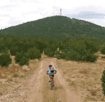
The major trails have nice trail markers like the one in the photo however there are plenty of minor trails to confuse things.

Cedro Ridge Trailhead

Cedro Ridge Trailhead at Picnic Ground

Cedro Ridge Trail doubletrack leaves the road to the east and descends with some great views. There is a steep descent just before the intersection of the Mighty Mule Trail and the Four Corners (Coyote Trail).
Cedro Peak Trail - Short steep road up to the fire lookout.
Cedro Singletrack Trail leaves the road east.
Forest Road FR542 goes west from the north end of the campground and goes about 3 miles west and south and terminates at Juan Tomas road near NM337. This follows a dry wash that has a lot of rocky "steps" as it descends to the road.
The hard Powerline/Chimosa Trail, unmarked, leaves FR452 west of the tower at the powerline. It starts steeply descending the rocky powerline. After a couple of switchbacks, a narrow, less-used trail takes off to the right (east) through dense juniper, pinon,scrub oak along the north side of the Cedro Ridge. The trail is definite but not used much until you get closer to the intersection with the Chimosa / Mighty Mule (marked). There are some really nice stretches but rocky. The trail climbs up and down several rocky drainages as it generally descends to the intersection. Take the Chimosa or Mighty Mule Trail at the intersection.

Chimoso Road Trails

Chamisos Canyon

Chamisos Canyon

Powerline Singletrack Trail goes south from FR462 near the parking lots off NM337. This is a really pleasant single track, smooth Then connects with the Chimoso Trail. The climb up the ridge to FR452 is very rocky.
Chimoso Singletrack Trail starts at the Powerline trail and gradually climbs eastward though very pretty meadows until hitting the Mighty Mule Trail. This trail is very smooth and easy for about 2 miles. The trail winds through the drainage at first until it breaks out into the meadow.
Mighty Mule Singletrack Trail starts at the Chimoso Singletrack and climbs steeply for a quarter of a mile until it levels off then continues easily until it crosses the Cedro Ridge Trail at the 4-Corners. Mighty Mule Singletrack continues as a pretty nice trail with a few rocky spots onto the short Rattlesnake Trail.
Coyote Trail singletrack at leaves the Chimoso Road at the road close and climbs through ponderosas and meadows to an intersection at the Four Corners. This trail has a lot of terrific dirt single track that winds through the pinon/juniper forests. There is climbing up and down on some rock steps but is largely a really nice ride.
FR462 double track climbs from Chimoso Road to a ridge with expansive views and continues north to the "Four Corners" which connects with the Coyote Trail, the Mighty Mule Trail, and the Cedro Ridge Trail. The trail from Chimosos Road to Cedro Campground via the Cedro Ridge Trail is about 6.8 miles.

Juan Tomas Road Area Trails

Mahogany Trail - This marked trail goes south with intersection with the Gamble Oak Trail to the Oak Flat Road. There are a lot of pleasant dirt single tracks here. Going north downhill, the trail is a bit more rocky but eventually intersects with Lower Pine and FR462 to the Tablezon or Chamisos trailheads. Note that there are two Mahogany Trails! One is a moderate marked trail and further east is the marked easy double track road that goes south past the Cutoff Trail and Gamble Oak Trail to Road 35 (marked) near Oak Flat picnic ground. The Road and Trail are about 1/4 mile apart where crossing the Juan Tomas Rd.
The Bear Scat Trail, marked, starts at the Juan Tomas Rd. across from the Mahogany Trail (road). Going north, this smooth single-track winds climbing through mixed juniper and pinon forests. There are a few rocky spots but it is mostly smooth to Harry's Trail. Bear Scat winds north through mixed pinon and ponderosa forest with some nice views east then climbs to the intersections at the Rocky Road, Poker Chip, and Pinon Trails.
Pinon Trail - From the Junction with the Bear Scat Trail on the ridge, the Pinon Trail descends north down a rocky hiking trail to a drainage through heavier wooded terrain. Then it descends down a section of rocky gully to where the trail opens out into meadows and then crosses the Lower Pine Trail in two marked intersections..
Harry's Trail, marked, starts on the Bear Scat Trail and takes off to the east then north. The trail begins as a nice single-track climbing through meadows and mixed pinon and juniper forests. There is then an unmarked intersection at a fence-line with a loop to the east, marked on the map. Continuing north, there is a hard, rocky climb up a ridge, and hard rocky descent, to the "29" junction on the map. At the top of the ridge there is an unmarked rocky trail (easily missed) that heads west to the "stairway to heaven". There are maybe five trails that converge at the "29" junction, all unmarked. Take the map. From the "29" the trail continues north, as a nice packed-dirt single / double track trail to the Longview maze.
Poker Chip Trail - Marked, begins on the north side of the Juan Tomas Road opposite the western Mahogany Trail (not road) and goes north.

Longview Area Trails - Unmarked, use the map. [Trailhead]

Departing to the east from the trailhead there is some initial rocky spots but mostly it is easy dirt singletrack. Eventually you can connect to Via Sedillo and return for a short ride.
Departing To the south there are more easy trails that take off to the west and connect with the Four Corners or south and connect to the Juan Tomas area.. There are MANY alternate trails not on the map in this area and none are marked.
An unmarked trail goes west 3.4 miles to the Tablezon trailhead. It is a little rocky and descends mainly to Tablezon.

Mars Court Trails

Oak Flat Area Trails [Trailhead]

The Ponderosa Trail starts on the Oak Flat Rd. east of the picnic area and goes east through the City Open Space and back to the highway. It also goes north, passes the Gamble Oak trail and connects with the Mahogany Trail which continues north, passing the Juan Tomas Rd.
The Mahogany Trail, marked, starts northeast of the Oak Flat picnic area. There is a gated road at the intersection with the Oak Flat Road. There is no parking at the intersection, unfortunately. Take this dirt road north and it hits the Mahogany Trail. Descending to the north, this hard-packed rockless double-track dirt road goes through mixed ponderosa forest and meadows to the Juan Tomas Rd. Very easy. The Mahogany Trail passes the Gamble Oak Trail and the Cutoff Trail that head back to NM337. Crossing the Juan Tomas Rd. northward, the Mahogany Trail becomes the Bear Scat Trail.
There is also an unofficial trail that starts in the USFS Oak Flat picnic area that connects with Trail 35 which goes north to the Ponderosa Trail and the Mahogany Trail.

Pine Flat USFS Picnic Area Trails

The Gamble Oak Trail takes off from the south end of the picnic ground and heads toward the Oak Flats area and the Mahogany Trail.

Tablezon Trails - A terrific 8.5 mile loop climbs gradually with some rocks from Tablezon up Lower Pine to Trail25, turns onto Trail23, then turns south downhill on mainly smooth dirt trails to Pinon 2-Trk that takes you back north to Lower Pine and back to the trailhead. The 8.5 miles includes the little jog out to the Longview Trailhead.

Lower Pine Trail singletrack leaves the parking area and climbs through ponderosas to an intersection with Trail25, Wildcat Trail.
Trail25, Wildcat, climbs east 4.6 miles to Longview. Follow the arrows along the way since there is an unmarked north turn that goes to the Five Hills gravel road.
FR462 double track climbs to a ridge with expansive views and continues north to the "Four Corners" which connects with the Coyote Trail.
Pinon 2-Track, Trail 22, climbs north from Lower Pine. This in a really nice trail and is mainly rock-free. It's terrific riding south to north.

Via Sedillo at Teypana Trails

Easier trails lead west across the open meadow towards the Longview trailhead and further west. Quite a maze of trails.


Cedro Peak Trails

Cedro Peak North Trails
Only selected trails are shown. There are lots of unofficial trails.
The trail data was collected with a Garmin GPS receiver and imported into Delorme Topo USA5.0.