|
 |
|
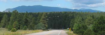
View South on NM337 from Pine Flat PG
|
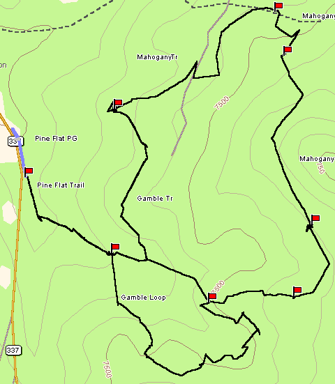
The Pine Flat Trails are mostly hard-packed dirt single track that
ride through mixed close ponderosa, pinon, and of course oak trees. These are excellent, well-marked trails that
wind up and down through the forests. There aren't many viewpoints but these are pleasant if short trails. Longer
loops can be linked together using the Mahogany Trail down to the Cedro Peak area.
Making a loop from the picnic ground of the Gamble Oak Trail, Mahogany Trail, Cutoff Trail, and
Gamble Oak Trail back to the picnic ground is about 5 miles with about 550' of elevation gain.
 Gamble Oak Trail
(Trail 44) - This single track trail leaves the Pine Flat Picnic Ground from the extreme south end of the parking
lot (fee area). There is a trail marker at the trailhead. Gamble Oak Trail
(Trail 44) - This single track trail leaves the Pine Flat Picnic Ground from the extreme south end of the parking
lot (fee area). There is a trail marker at the trailhead.
The trail begins a gradual climb over a few rocks then on a nice dirt single-track to the marked Gamble Oak
Loop. The route to the right is a less well traveled trail but is still moderate as is climbs and drops as
it loops around to the marked Mahogany Trail. The Mahogany Trail is double track for a while as it
travels north.
At the intersection of the The Cutoff Trail descend west over a moderate rocky but rideable stretch to the
parallel Mahogany Trail. Then loop back to the junction with the Gamble Trail again. This is an excellent
stretch that winds through the trees on excellent packed dirt single track back to the junction with the Gamble
Trail Loop.
Pine Flat Trail
- Short marked trail leaves the extreme south end of the Pine Flat PG (marked) and connects with the Gamble
Oak Loop.
Mahogany
Trail (map Trail 6) This marked trail goes south from the Juan Tomas Rd to the intersection with the
Gamble Oak Trail to the Oak Flat Road. There are a lot of pleasant dirt single tracks here. Going north downhill,
the trail is a bit more rocky but eventually intersects with Lower Pine and FR462 to the Tablezon or Chamisos trailheads.
Note that there are two Mahogany Trails! One is a moderate marked trail and further east is the marked easy double
track road that goes south past the Cutoff Trail and Gamble Oak Trail to Road 35 (marked) near Oak Flat picnic
ground. The Road and Trail are about 1/4 apart where crossing the Juan Tomas Rd.
|