|
The East Sandia Mountains have a lot of popular
trails that are commonly used by mountain bikers. Not all are well known. The following are some of the trailheads.
Start with the good Trails of Cedro Peak & Otero Canyon map. Most areas have lots of trails that don't show up on the maps so stay alert. There are way more
trails than are on the map. Most trails do not have trail markers.Always carry more water, food, and repair tools
since it is easy to miss trails and wind up on a longer ride than expected. This said, there are great trails of
all experience levels and lengths.
There are other places where trails come out but where there isn't much parking. You might have
to park and ride some roads to find the trailheads.
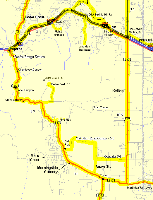
There is a USFS Ranger station on NM337 about a mile south of Tijeras that has bathrooms, water
(weather depending), and parking. You can purchase the map there if they have any.
Trailheads:
- Bartolo Baca (Tablezon) - This trailhead is near the Zuzax I-40
exit, 178. There is a "Bartolo Baca" sign at the south turn off NM333 (old RT66) just west of the Zuzax
gas station by the mailboxes. Turn south, uphill, on the paved
Kennedy Lane .7 miles to the stop sign "T", turn right .3 miles to the marked "Forest Road"
turnoff on the right. FR462 is rough for the first 1/4 mile where there is a small parking area before FR462 climbs
to the scenic mesa. There is a marked trailhead for the Lower Pine Trail at the parking area. FR462 continues uphill.
- Cedro Peak Campground - Take NM337 five miles south
of Tijeras, turn left (east) on the paved Juan Tomas Rd. 1/2 mile to the turn onto the gravel Cedro Peak Campground
Rd., FR252 (there are signs) 1.5 miles to the Cedro Peak Group Campground at the north end. There is trailhead
parking at the campground. There are a variety of trails going east, north, and west from the campground. Cedro
Peak is the one with the watchtower on it. Trail 13, Cedro Ridge Trail, takes off east from the road near the north
parking lot. Cedro Peak Singletrack takes off east from the road near the entrance of the campground. There
is water and toilets available at the campground.
- Chamisos Canyon Rd. - Take NM337 south from Tijeras about 1-1/4
miles to the gravel Chamisos Rd on the east. You can see two small parking areas on Chamisos just to the east.
There are several trailheads east of the parking lots. Ride FR462 east to connecting trails to the Cedro Peak area.
The Coyote Trail is at the end of the road.
- Juan Tomas Rd. - Drive east on paved Juan Tomas Rd. from NM337
south of Tijeras. It turns to dirt for a while. In a clearing you will see a double/single track heading south
(and north - less obvious). The Mahogany
Trail is marked which then turns to a single track as it goes south. The northern section
is pretty rocky in places. Also, there is room to park just
off NM337 at the intersection with FR452. This is pretty rocky
and is uphill to the Cedro Peak Campground.
Continuing east on Juan Tomas you come to a second marked Mahogany Road on the south and marked Bear
Scat Trail on the north.
- Longview Dr. -
Turn south onto the paved Five Hills Rd (marked) 1-3/4 miles west of the Sedillo Hill exit on NM333. About 1/4
mile south bear left onto Longview Dr. . About 1-3/4 miles later Longview dead ends at a gravel cu-de-sac where
there is limited parking. A real maze of easy trails takes south off here. Be careful, it is easy to miss your
return route.
- Mars Court - Off Raven Rd. across from Oak Flat Rd.
- Oak Flat Road - The Oak Flat Picnic Ground is about a mile east
off NM337 on Oak Flat Rd. Just east of the entrance north of Oak Flat Rd. there is an entrance to national forest
trails (Trail8) then further east there are several small entrances
to several open spaces that have great, easy trails. There is limited parking at the access points. Private land
is on the south side of the road. There is limited parking just off the road but there is lots of space in the
Oak Flat P.G.
- Otero Canyon - This marked parking area is off NM337 south of Tijeras.
The Air Force has closed parts and is citing trespassers so obey signs on the trail. This is a popular area.
- Pine Flat Picnic Ground - 7 miles south of Tijeras on
NM337 on the left (east) of the road.The marked Gamble Oak Trail starts from the southern end picnic area where
this is a wide trail heading south east. There is a number of easy to moderate trails in the area. There is parking
at the USFS (fee area) picnic area.
- Tijeras Ranger Station - There is a nice new USFS Ranger Station
on NM337 just south of Tijeras. They have a parking lot where you can ride from up NM337 or NM333 to trailheads.
- Tunnel Canyon - This marked parking area is off NM337, south of
Tijeras.
- Via Sedillo Road at Teypana Rd - There is a trail intersection here but there is no parking.
- Via Sedillo Road End - Also, there are a number of trails that
take off from the end of Via Sedillo Road. There is a "Road Closed" sign that has been there for years.
Just past this there is a high point where trails take off to the west. This is shown on the Trails Map.
Notes:
- Get a copy of The Trails of Cedro Peak & Otero Canyon ($7) from the Sandia Ranger Station or local bicycle shops.
- Some of the trails are written up in the several mountain biking Albuquerque or New Mexico books.
- Cibola National Forest.
|