| Since the Gila Inner Loop Tour is a loop, it can begin and end at any point. First there is the moderate climb out of Silver City into the pondersosa forest to Pinos Altos, a lively ghost town. Take the left hand branch through the town that reconnects with NM15 on the other side of town. The road then drops down and climbs back up to the Ben Lilly Memorial. |
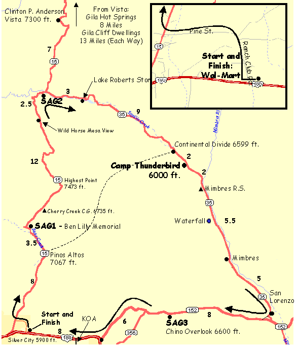 There is a plaque at the Ben Lilly Memorial on a rock
outcrop west of the highway. The route drops into a delightful aspen
lined canyon passing the Cherry Creek Campground. The Wild Horse Mesa
has great views of the Gila National Forest. There is a fast steep
descent to the intersection of NM15 and NM35. There is a resturant at
the intersection. There is a plaque at the Ben Lilly Memorial on a rock
outcrop west of the highway. The route drops into a delightful aspen
lined canyon passing the Cherry Creek Campground. The Wild Horse Mesa
has great views of the Gila National Forest. There is a fast steep
descent to the intersection of NM15 and NM35. There is a resturant at
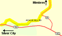
the intersection.At the intersection of NM15 & NM35 follow the creek and NM35 east to Lake Roberts store where you can get some drinks. Then there is a climb to the Lake Roberts overlook. There is a parking area on the left with bathrooms. The road climbs a little through ponderosa forest and there is finally a climb over the Continental Divide. Then there is just a little way to Camp Thunderbird which is on the south side of the road and has a prominent sign. The delightfully wooded route continues east from Camp Thunderbird through Mimbres, passes a small waterfall on the right (south) when there is any water, onto San Lorenzo. The route opens up and there are nice views south of Cooke's Peak. Take the right at Acklin Rd. in San Lorenzo that parallels NM152 for a little while. If you miss this, no problem, continue 1/4 mile on NM35 to the intersection with NM152. There is a moderate climb up NM152 which is 4 laned, has shoulders and more traffic. Then there are some rolling hills to the Hurley Mine Overlook. Be careful of the railroad crossing at the bottom of one hill. Don't take the turnoff to Fiero, it doesn't go anywhere. Continue on the rolling hills to the intersection with US180. Turn right on US180. You pass the Ft. Bayard Hospital. There are some so-so mountain bike routes that start from there. There is moderate traffic on US180 which has shoulders but watch for all the debris. There are a few more rolling hills as you enter Silver City. |