|
 |
|
Tramway Bikepath
|
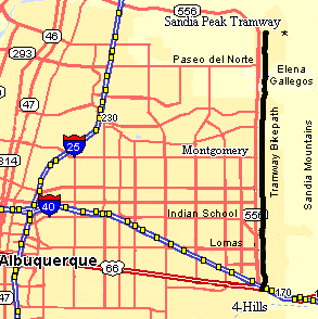
The Tramway Bike Path, paralleling the Sandia
Mountains on the East side of Albuquerque provides awesome views of the Rio Grande valley, and close-up views of
the Sandia Mountains. The route is nicely landscaped and has a number of nice turnouts and benches along the way.
The Tramway Bike Path runs from I-40 and Central north to Tramway Lane where the road up to the Sandia Tram begins
on the east side of Tramway.
This is a very popular route so start early, especially on weekends. There are numerous walkers,
runners, skaters, and baby strollers using the trail, too. The bike path is very open and crosses mainly through
residential areas and is a very pleasant ride. This is a great route to take your kids or grand-kids to learn to
ride.
The Tramway Bike Path crosses all the intersecting roads at grade, most using the pedestrian crossings. Use extreme
caution at the crossings. Even though most have traffic lights many of the intersections have right turn lanes
where cars zip around the right turns without looking for joggers, pedestrians or cyclists. There are fewer crossings
north of Montgomery. Most of the crossings have pedestrian signals but these do not give pedestrians their own
protected turn so watch for turning cars - they aren't looking for you.
Many experienced riders prefer to ride on the excellent, fast shoulders along Tramway from I-40/Central to I-25
rather than dodging turning cars and baby strollers.
There is also a paved sidewalk west of Tramway paralleling it from the north side of Montgomery north several
blocks that is appropriate mainly for children, baby strollers, and walkers.
Be careful crossing at Central Ave. and I-40, it's very busy. There are two right turn lanes
on southbound Tramway where right turning cars don't see you if you're using the pedestrian crossing.
Getting There: The Tramway Bikepath crosses all the highways at
grade so there are numerous shopping centers along the way where you can park, including Montgomery and Indian
School. You can start at the 4-Hills Smiths but you have to cross Central.
Distance: The end-to-end distance from I-25 to the Tramway Rd. stop
sign is about 8.5 miles. There are a number of hills along the way so it is not as easy as the Riverside
Trail.
Roadway: The Tramway Trail is paved and varies is width. It has
a number of wooden bridges, be careful on winter mornings. The Tramway Bike Path crosses all the intersecting roads
at grade, most using the pedestrian crossings. Use extreme caution at the crossings since most motorists are not
looking for cyclists and most run the red lights on right turns without looking. Also, there are lots of pedestrians.
Connections:
- Tramway is a major north/south highway crossing several east west bike paths and bike routes
in a addition to numerous artierals. Tramway has an excellent shoulder all the way from Central/I-40 to I-25 in
the west.
- There are large wooden bridges over south Tramway which connect to east-west bikepaths.
- There is a connection to the I-40 bikepath at I-40 and Central.
Options:
- Tramway Lane - Hard climb to the Sandia Tram at the north.
- Juan Tabo Picnic Ground - Very rough, hard climb.
- Elena Gallegos Open Space - A steep ~2 mile climb to the Elena
Gallegos Open Space. Water, bathrooms, and great views available.
- Tramway Blvd. is included as portions of other rides such as the Bernalillo
Blast, Foothills Frolic, etc.
Notes:
- This is a popular cold weather ride though it is prone to south winds.
- Be careful crossing the wooden bridges in the rain or if there is ice early in fall or spring
mornings.
- There are a number of convenience stores along the way.
- Use extreme caution at the crossings since most motorists are not looking for cyclists and most
run the red lights on right turns without looking.
|

