Seboyeta Out and Back

 
Cerro de la Celosa

Cerro de la Celosa

The Seboyeta Out and Back ride in central New Mexico is a beautiful ride. The route is pretty flat and fairly short which makes it a great beginner's or morning ride.

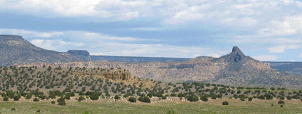
This ride takes you into the rural lands of Laguna Pueblo east of Grants. This ride goes into mesa lands east of Mt. Taylor riding through open terrain with scattered juniper and cedar trees along the way. There is evidence of past volcanic activity from the volcanic rocks along the way. There is a little light traffic.

Cerro de la Celosa is one of many volcanic "necks" in the area. Cabezon is probably the largest in the region. These are formed by lava eruptions in the geologic past where a tube of magma pushes its way to the surface the igneous material spreads over the land. Then, in following years the softer surrounding layers erode away leaving the harder, denser igneous "neck".

Route Map

Route Map

The maps spell this as Cebolleta but all the highway signs are spelled Seboyeta which seems to be the phonetic 
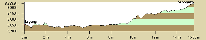
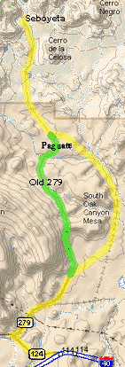
spelling. (Celosa in Spanish means "jealous"?)

Thanks to the Chile Pedalers for developing this ride. This is definitely "tandem territory".

Getting There: Take I-40 west from Albuquerque to the Seboyeta exit at exit 114 at Laguna. Exit the interstate and drive about 1/2 mile west on the north side of I-40 to the Conoco station, the only one. Park in the dirt lot.

Distance: 31 miles round trip, only total 1,250 ft. gain, 855 ft. gained riding north to Seboyeta.

Roadway: All paved in good condition,some shoulders, light traffic.

Notes:

There is a convenience center in Paguate which may be open.

Options:

  • There is an optional climb about half way. Take the "Old Route 279" turn west about half way to Seboyeta. You can see the climb from 279. The route then goes into Paguate and reconnects to "new" 279.
  • If there aren't enough miles in the standard route, ride rt66 east through Laguna to Mesita and back. The traffic isn't much.
  • Also, see the Acoma Loop.


Seboyeta CueSheet // 31 Miles, 1200' Elevation Gain.
Mileage Waypoint Leg Description

0

Conoco gas station Begin at the Conoco gas station. Ride west on the divided NM124 (Rt66) to the Jct with NM279.

1.5

Jct 279 Turn right. There is a sign for Bibo and Seboyeta. Stay on NM279 all the way to Seboyeta where the pavement ends in the middle of town at the Our Lady of Sorrows church.

15.5

Seboyeta Return by the same route.

Elevation Profile

The total elevation gain 1,250' with about 855' of elevation gain riding from Laguna to Seboyeta.
Note that the elevation change below is only about 700'.

Elevation Profile