 |
|
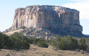
Enchanted Mesa from the North |
After entering the reservation, the loop passes the impressive Enchanted Mesa, Kadzima, along L23/L22 (L==Laguna Reservation). The area is pretty flat and open with wide vistas. The ride passes the Sky City at the junction of 38 & 23 at the museum but does not climb up the mesa.
Then there is the one climb up Deadman's Rock Overlook, also know as the Kuumi Scenic View, but it's not very long. The overlook has a great view of Sky City but photos are forbidden. Then it's downhill to McCarty's with Mt. Taylor in the distance.
Bring plenty of water and snacks. Both of the two options cover essentially the same loop, they just start in different locations on the loop. There are great views of Mt. Taylor, in the spring snow-covered, to the north on the return ride on Acoma38.
This ride is best in the spring or fall to avoid the heat of the summer. Spring can get windy and late fall can get snow if you're unlucky.
The interesting small museum at the intersection of L23 and NM38 at the Acoma Pueblo burned down recently, a great loss. There is a new museum and visitor's center being planned. In the meantime, there are some portables where you can get some snacks and restrooms.
Take care at the intersection of NM124 and L22 (Laguna), it is easy to miss and you would wind up in Laguna. It has happened, bonus miles! The abandoned Paraje Trading Post that was a useful landmark has been demolished. There is a standard green highway boundary sign for "Paraje" just west of the turn.
Getting There: There are several options available.
- Start at Casa Blanca at I-40, exit 108, 53 miles west of Albuquerque. There is a grocery store, Dancing Eagle Casino, and gas station on the south side of I-40.
- Start at the Sky City Casino at I-40, exit 102, 59 miles west of Albuquerque. Park behind the gas station on the north side of I-40 in the dirt lot. There is lots of truck traffic.
Distance: Since it's a loop you can begin anywhere on the loop.
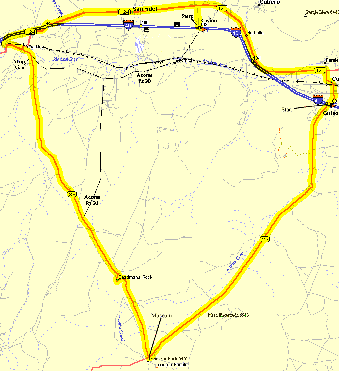
- Acoma Pueblo Casa Blanca Loop, 42 miles, 1,130 ft. total elevation gain.
- Acoma Pueblo Casino Loop - 42 Miles, 1,130 ft. elevation gain.
Roadways: The roads are mainly 2-lane rural roads without shoulders with very light traffic. Some of L23 south of Blanca has been recently paved and has shoulders for a way.
Options:
- There is a shortcut at the intersection of L23 & NM38, at about 5.6 miles north of the museum and about 2.5 miles north of the overlook, that turns northeast (right) to Acomita then under I-40 at exit 102 that is shorter than going through McCarty's. There is a sign at this intersection.
- Lavaland Lolli-pop Loop: About a 8-mile option. At the intersection of NM124 & NM38 at McCarty's ride west about 1.8 miles, over an old bridge, to a paved "Y" to the south. Turn southwest on Indian Service Route 33 and ride about 3 miles as it meanders paralleling I-40 through the lava fields. The road returns to the I-40 frontage road. Turn right (east) on the frontage road riding about 4 miles through interesting lava formations back to the NM124 & 38 intersection. This is pretty flat and has nice views in all directions.
- See the Seboyeta Out-and-Back near Laguna Pueblo.
Notes:
- Wikipedia: Acoma Pueblo
- Photos are forbidden on the pueblo. There are signs on the Deadman's Rock Overlook (Kuumi Scenic View) which overlooks the Sky City restricting photographs. These regulations are enforced.
- There are tours of the Sky City for a price from the museum at the intersection of L23 & NM38 that is worth the trip if you have time left after the ride. Some of the guides are very knowledgeable.
- Watch for dogs.
- Rt66: Laguna Pueblo Area
- Rt66: San Fidel
Area
- Sky City Cultural Center
- Acoma Pueblo Museum - 12 miles SW of I-40 on L23. Bathrooms.