Note that the elevation range is only about 500'. Bernalillo to San Ysidro and back is only about 1,200' of elevation gain - pretty flat.
San Ysidro Scenic Circuits
The San Ysidro Scenic Circuits follow US550 to San Ysidro and provides awesome views of the Jemez Mountains to the north and the wilderness study areas to the south and the Sandia Mountains on the return. This ride is a good one for the winter months. It can be pretty hot in the summer. The route is pretty open and vulnerable to the winds. There are several ways to begin this ride in Bernalillo and there are options beginning at San Ysidro. This is a favorite training ride since there are no stop signs or traffic lights west of the casino.
Getting There: Take I-25 north of Albuquerque to Bernalillo or begin in Rio Rancho as in the rides below.
Roadway: US550 was rebuilt in 1998 with new 4-lanes and shoulders with rumble strips. Be careful coming up to guard rails since some of the rumble strips get pretty close. The speed limit is up to 65+ now. Unfortunately, the rumble strips make it uncomfortable to ride 2 abreast right of the rumble strip and are deep, so when riding in pacelines crossing them are not pleasant. So far, debris has not accumulated to the point to make the shoulder unrideable.
Distance: Star Casino to San Ysidro out and back Option, 43 miles roundtrip, 805' elevation gain out, 1225' elevation gain total, rolling hills, mainly a 500' hill west of Rio Rancho.Start at the Star Casino with big parking lots at US550 / NM528 west of Bernalillo to skip the Bernalillo traffic. Park at the far north west end of the lot.
Options:
- Coronado Monument and State Park to San Ysidro out and back, 44 miles.
- Rio Rancho to San Ysidro out and back, 56 miles.
- There is a park-and-ride lot at I-25 and exit 242 on the west side where you can park but this makes you ride through Bernalillo.
- Start in Albuquerque and ride north on the repaved NM313 to Bernalillo and continue to San Ysidro from there.
- Take a ride north on NM4 north from San Ysidro or continue on US550 towards Cuba (quite a long way).
- The San Felipe Flyer is another ride starting from Bernalillo.
Notes:
- There is a Maverick convience store in San Ysidro for snacks.
- There are bathrooms in the casino.
- US550 used to be named NM44 on older maps.
San Ysidro Scenic Circuit from Coronado Monument and State Park
The San Ysidro Scenic Circut from Coronado Mounument and State Park Ride begins and ends at the Coronado Monument Visitor Center.
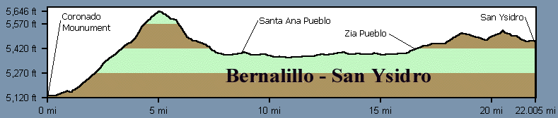
Distance: 44 Miles, 1,740' elevation gain.
Getting There: Drive north from Albuquerque to Bernalillo, exit 242, then west on US550 just across the Rio Grande to the Coronado Monument Visitor Center.
San Ysidro Scenic Circuit from Coronado Monument and State Park // 44 Miles, 1740 feet Total Elevation Gain
Mileage Waypoint Leg Description 0
Coronado Monument Visitor Center Ride right (west) on US550 to San Ysidro. There is some parking just south of the visitor's center. 22
San Ysidro Pause to recover at the convienence store then return by the same route. There is a Maverick convience store at San Ysidro. Return by the same route. 44
Visitor Center
San Ysidro Scenic Circuit from Rio Rancho
The San Ysidro Scenic Circuit from Rio Rancho begins and ends at Southern Plaza at Southern and Unser in Rio Rancho. This ride has rolling hills along Unser but is mainly flat along US550.
Distance: 56 Miles, 1580' elevation gain.
Getting There: Start and end at Southern Plaza in Rio Rancho.
San Ysidro Scenic Circuit from Rio Rancho // 56 Miles, Total 1580 ft. Elevation Gain
Mileage Waypoint Leg Description 0
Southern Plaza Ride north on Unser 11.4 miles to US550 at the National Guard armory. 710 ft. elevation gain at this point. 11.4
US550 Left (west) on US550 17 miles to San Ysidro. Another 110 ft. elevation gain. 28
San Ysidro Return to Rio Rancho by the same route. 56
Southern Plaza
Coronado Monument to San Ysidro Elevation Profile
Note that the elevation range is only about 500'. Bernalillo to San Ysidro and back is only about 1,200' of elevation gain - pretty flat.