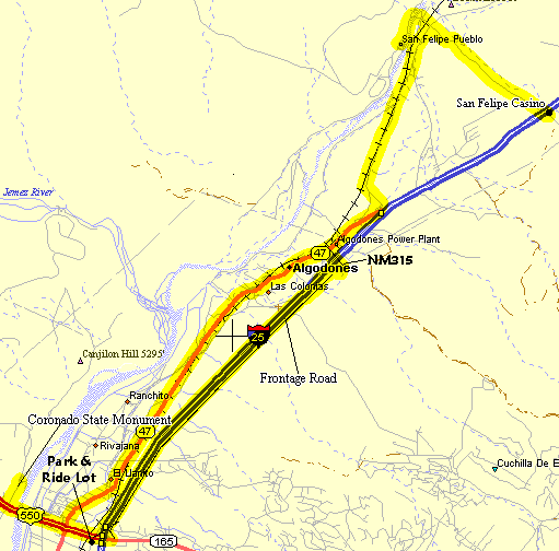
San Felipe Flyer
The San Felipe Flyer is a classic thrill-filled ride through the scenic valley north of Bernalillo. This is a good spring or winter ride with low elevation, so it is warmer. It has light traffic and nice scenery with good views of the Sandia Mountains. It is also pretty flat. A pleasant ride. It's not as open as some rides so it doesn't seem as windy. The ride goes through rural areas north of Bernaillo to the San Felipe pueblo. NM313 from Bernalillo to San Felipe is part of the historic El Camino Real Scenic Byway that runs from Santa Fe to El Paso.
Distance: 31 Miles + options, pretty flat (800' elevation gain).
Getting There:
- This ride begins and ends at the Coronado State Monument west of Bernalillo, north of Albuquerque, west of the Rio Grande on US550.
- An alternate starting location is the park-and-ride parking lot at I-25 and US550 on the south side of US550. This has been paved recently (4/2003). This option avoids most of the traffic in Bernalillo.
- Another alternate starting location is at the Santa Anna Casino overflow parking lot on US550 just west of Bernaillo.
Roads: The roads are mainly 2-lane roads with no shoulders but there is usually virtually no traffic. There are shoulders along the I-25 east frontage road. There is some gravel truck traffic along here from the quarry but are not a problem. There is moderate traffic in the center of Bernalillo. NM313 from the south side of Algodones north to the San Felipe Elementary school has been nicely repaved (3/2008).
Notes: There is a gas station/resturant at the San Felipe Casino to get snacks or water.
Options:
- You can length the ride with an excursion to the Jemez Dam.
- Or continue north on I-25 from the Casino, there is no shoulder until the Waldo exit.
- Or ride south on NM313 through Bernalillo.
- Or ride south on NM528 to Rio Rancho.
- When riding through Bernalillo on NM313, try the delightful Rio Grande Loop Option below.
Classic San Felipe Flyer CueSheet
|
|||||||||||||||||||||||||||||||
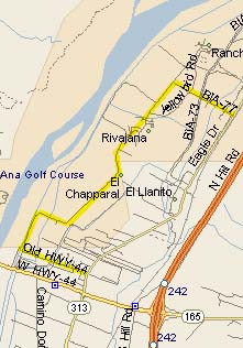
Bernalillo Rio Grande Loop Option
Try the Bernalillo Rio Grande Loop Option when riding through Bernalillo on NM313 in Bernalillo. This is a suprisingly pleasant, rural ride, all paved, starting right in the middle of the congestion that Bernalillo is becoming. Thanks to Dennis and Dede for finding this route.
Bernalillo Rio Grande Loop Option CueSheet
Mileage Waypoint Leg Description 0
Old RT44 & NM313 About .15 miles north of US 550 turn west on a small road marked Old RT44. The speed limits are 25mph and usually no traffic at all. Old RT44 parallels US550 until it dead ends at Santa Ana almost in the Rio Grande. .5
Santa Ana Rd. Turn right (north) onto Santa Ana Rd (marked) and follow the diversion channel. You are now riding through farms and open fields on the San Felipe Indian Reservation as the road curves east then north again. 2.75
Fire Danger Sign Turn right on a BIA road just past the pueblo office buildings. If you keep going the road just dead endts. 3.3
NM313 Passing by Day Care Rd, you're back to NM313. Turn north or south depending on your trip.