Jemez Dam Area Rides
The Jemez Dam Ride is a pleasant open ride six miles north of US550 west of Bernaillo that has nice views of the nearby Jemez Mountains to the north and a distant view of the northern Sandia Mountains to the south. There is a picnic area at the Jemez Dam overlook with covered picnic tables. There are several options that include this ride to make it longer. The elevation is low and the terrain is open so start early to beat the heat and winds.
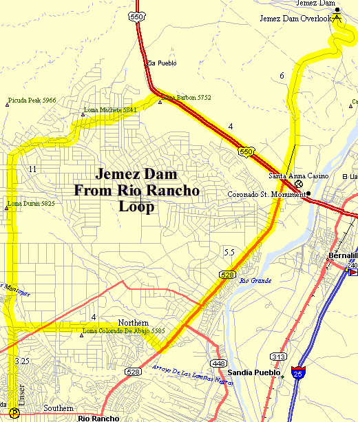
Getting There: The Jemez Dam is about six miles north of US550 west of Bernalillo. Options include this section to extend the distance. The turnoff is across from NM528 shown on the map below.
Road: There is almost no traffic and the roadway is typically 2-lanes with no shoulder in ok condition.
Distance: Jemez Dam from Rio Rancho, 41 miles, 1,870 feet Total Elevation gain.
Options: Ride west on US550 to San Ysidro and back. There are several optional starting locations including Corrales, Bernalillo, or north Albquerque: ride up the frontage road to Bernalillo.
Notes: This option begins at the Southern Shopping Center at Unser and Souther in Rio Rancho. No, Unser does not connect from the south yet.
Be aware that some drivers in Rio Rancho don't seem to be aware that bicycles are allowed to ride on roads.
Rio Rancho to Jemez Dam CueSheet // 41 Miles 1,870 Ft. Elevation Gain
Leg Mileage Waypoint Description 0
Southern Shopping Center Ride North from Unser and Southern climbing rolling hills past the National Guard installation to US550. 11
US550 Turn right (east) onto US550, travel along the new paved sloping shoulder to the turn to the new road to the soccer fields a quarter mile before Jemez Dam Rd. The old Jemez Dam Rd. is at the traffic signal at the Santa Anna Casino. 15
Soccer Fields Rd Turn left (north) onto the new soccer fields road. Follow it down and up the hills to the Jemez dam overlook. There is a picnic area with covered picnic tables at the overlook. You overlook the dam and Jemez River and the Jemez Mountains in the north. If you miss the soccer fields road just turn left (north) at the Casino on Jemez Dam Road. 21
Jemez Dam Overlook Return by the same route south to US550. 27
US550 & NM528 Continue straight through the intersection (south) on NM528. 32.5
NM528 Follow NM528 climbing rolling hills 5.5 miles to Northern. The new pavement has shoulders but watch for debris. 36.6
Northern Turn right (west) on Northern, follow Northern 4 miles to Unser. 39.8
Unser Turn left (south) on Unser, follow Unser back to the starting point at Southern. 41
Southern Shopping Center
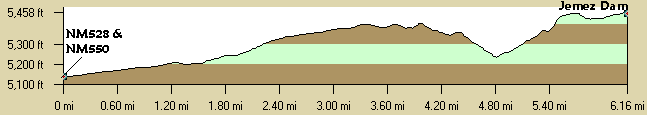
Jemez Dam Profile
Note that this is just the profile from NM550 to the dam since there are so many different routes to the dam. Also, note that there is only about 300' elevation change overall.