| Overall Mileage |
Leg Mileage |
Day Elevation Gain (Feet) |
Leg Description |
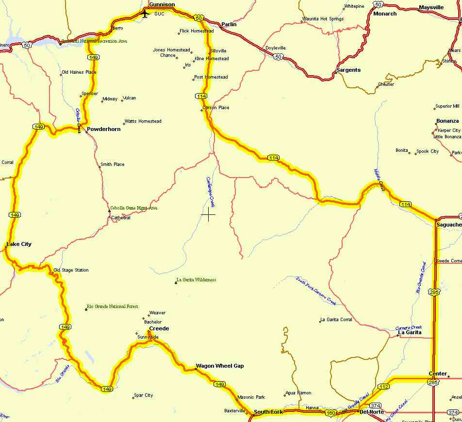
| Day 1: Saguache (7,694', pop. 600) - Creede |
|
0
|
0
|
1,560'
|
Saguache: Take US285
south from town. Good pavement, moderate traffic. |
|
23.5
|
23.5
|
CO112: Turn west (right)
Convience Store at corner. Moderate traffic, US285 has shoulders on and off. |
|
37
|
37
|
Del Norte: Take US160
west. Resturants. More traffic but good pavement. |
|
53
|
53
|
South Fork: Take CO149
northwest. Resturants. Follow the Rio Grande along a pretty route. |
| |
|
Wagon Wheel Gap: Several
resturants at dude ranches along here. |
|
74
|
74
|
Creede: There are plenty
of places to stay in this old mining town. Lots of history. Short climb into town. |
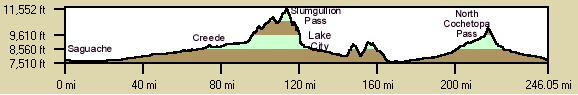
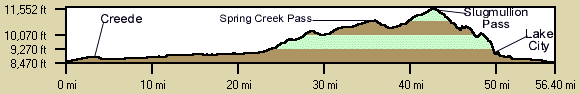
| Day 2: Creede (8,854', pop 600) - Lake City: |
|
74
|
0
|
4,000'
|
Creede: Take CO149 west
from town to Lake City. Follow the Rio Grande. |
|
93
|
19
|
Fremont General Store
(food). Continue on CO149 past turnoff to Rio Grande Reservoir (dirt), the headwaters of the Rio Grande. Begin
moderate climbing. Pass campground with South Spring Creek Falls. Up a dirt road 1/4/ mile and 900 ft. walk. Ok,
but the next falls are much bigger and impressive. |
|
102
|
28
|
North Spring Creek Falls.
1/2 mile off highway, paved. Big Falls, great view. picnic area. |
|
109
|
35
|
Spring Creek Pass (10,901'
) Picnic area, toilets, no water. Last 2 miles are steep. Fast descent. Watch for moose. |
|
117
|
43
|
Slugmullion Pass (11,361')
Hard 4 miles, especially the last 2. High speed descend. Be careful on tight turns. |
|
119
|
45
|
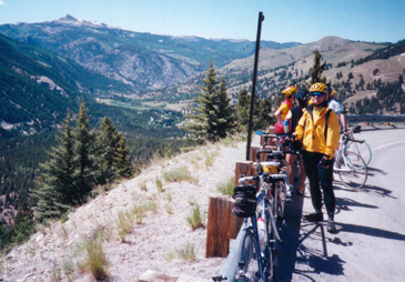
Windy Point Overlook:
Spectacular 14ers overlook. |
|
124
|
52
|
Lake City: A delightful
area. Plenty of places to stay and campgrounds. 14ers in the area. The Alpine Loop, gravel road. San Cristobal
Lake, Alferd Packer, ... |
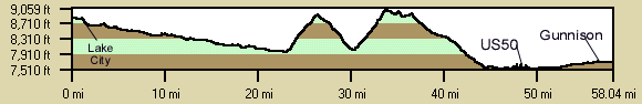
| Day 3: Lake City (8,675' pop. 200) - Gunnison: |
|
124
|
0
|
2,500'
|
Lake City: Take CO149
north out of town. There are no stores, towns, or convience stores along this route, so take water and food. Mostly
2 lane road with no shoulders, very light traffic. Very pretty route following the Lake Fork of the Gunnision until
the turn up the two steep climbs near Powderhorn. Then a fast, long descent to US50. Descents are open and straight
making for really fast descents. |
|
169
|
45
|
US50: There is a picnic
area with water at the reservoir before the intersection with US50. Travel along the south side of the Blue Mesa
Reservoir in the Curecanti National Monument. Cross the bridge and intersect US50. Turn East (right) on US50. US50
has more traffic but shoulders. |
|
178
|
54
|
Gunnison: There are plenty
of places to stay, eat, and camp. |
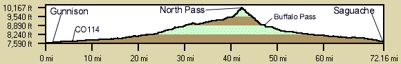
| Day 4: Gunnison (7,681' pop 4,600) - Saguache:
No water or facilities until Saguache. |
|
178
|
0
|
|
Gunnison: Travel East
on US 50 out of town. |
|
186
|
8
|
3,000'
|
CO114: Turn south (right)
on CO114. Follow Cochetopa Creek climbing to the pass. Gradual climb until the last 2 miles (5%). There are several
toilets along the creek. Climb through stunning igneous rock canyon. Beautiful section. 2 lane road, no shoulders
mostly, very light traffic, bumpy in spots.. Saddle before the last climb has great views of San Luis Peak. |
|
217
|
39
|
North Cochetopa Pass
(10,149). Information signs. Fantastic descent for the first few miles then most of the way into Saguache. Views
of Blanca and Little Bear 14ers to the south. Mainly 2 lane road with very light traffic, better surface. |
|
|
|
Buffalo Pass - campground
several miles off the road. |
|
248
|
70
|
Saguache, yipee great
ride. A couple of cafes at the intersection and a motel 1.5 mile south of town and hotel. |