 |
|
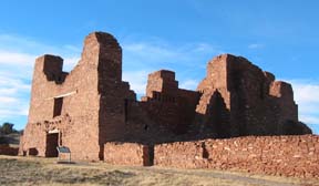
Historic Quarai Ruins N of Mountainair |
The Salinas Pueblo Missions National Monument visitor
center for the Abo, Quarai, and Gran Quivira Ruins is at the Shaffer hotel at the corner of Broadway & Ripley
in Mountainair. An uphill 1-mile paved road west of Punta del Agua takes you past the impressive ruins to the visitor's
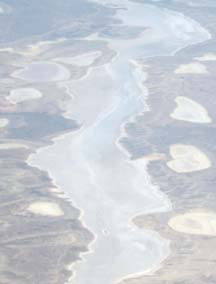
center and are worth a visit. The turn is signed. The south end of the north-south line of salt lakes in the Estancia
valley crosses US60 east of Willard. Take plenty of water since it can get pretty hot on these open roads.
Distance: 60 miles, 2300' elevation gain. pretty flat.
- Tijeras - Mountainair (one way), 54 miles, 3,030' elevation gain.
 |
|
Estancia Dry Lakes |
Roads: NM41 and NM55 are mostly 2-lane highways without shoulders but with light traffic. Some of the pavement around Tajique is rough but all is in acceptable condition. US60 is 2-lanes with no shoulders but has surprisingly light traffic and has a good surface.
Options:
- Also, see the 115 mile Moriarty Loop, or
- The two day Mountainair - Albuquerque 144 Mile Loop (2-day option).
- An uphill 1-mile paved road west in Punta del Agua takes you past the impressive ruins to the Quarai ruins visitor center and are worth a visit. There is a short walk to the ruins. Punta del Agua is about a block long so it's easy to find.
- NM542 from NM41 to NM55 is paved, no traffic, and avoids US60.
- The Salinas National Monument's Gran Quivira ruins are 26 miles south of Mountainair on NM55.
- The Salinas National Monument's Abo Ruins are 9 miles west on US60 (towards I-25) and 1/2 mile north on NM513.
Notes:
- There is a small grocery in Tajique and there may be a new cafe. Cafes are located near the intersection of NM55 and US60 in Mountainair. A small convienence store and the Willard Cafe are in Willard a couple miles east of the intersection of US60 & NM41. There is a grocery store in Estancia by the post office, visible from NM41, and two convienence stores. Sometimes there is a cafe in Estancia.
- Quarai Ruins Overview | Quarai Ruins Trail Guide | Quarai Ruins Map
- Salinas Pueblo Missions National Monument