Moriarty - Mountainair - Tijeras Loop


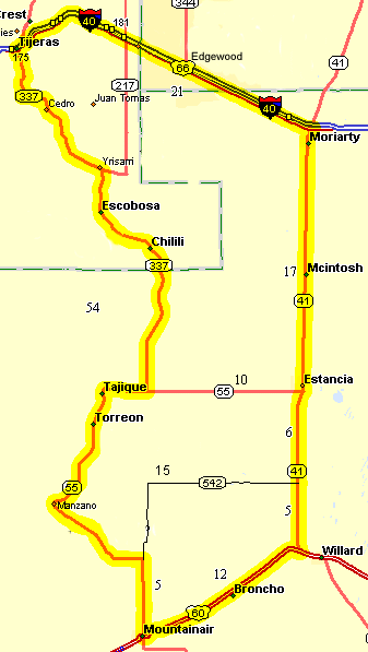
The Moriarty - Mountainair - Tijeras Loop is long loop in the East Mountains running from Tijeras to Moriarty to Estancia to Mountainair to Tajique to Tijeras.
Route Map

Moriarty Loop

This entire ride has great views of the Manzano Mountains and Manzano Peak (10,098') to the west. As you ride south from Estancia, Mesa Jumanas is visible to the south. The route is mostly in the open so vulnerable to winds and summer thunderstorms. The total mileage depends on where you start and stop. The leg from Mountainair to Estancia and onto US60 is quite flat and fast. The description below begins and ends in Tijeras. The nicest section is from Moriarty south through Estancia to US60, flat straight, and fast. NM41 south of Moriarty is the Salt Missions Scenic Byway. The Salinas Pueblo Missions National Monument visitor center for the Abo, Quarai, and Gran Quivira Ruins is at the Shaffer hotel at the corner of Broadway & Ripley in Mountainair. The ruins are worth a visit.

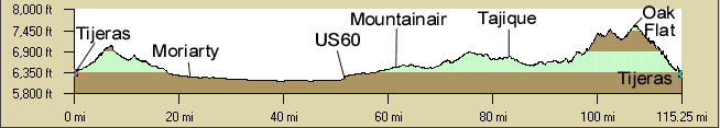
Distance: 115 miles (Tijeras - Moriarty - Estancia - Mountainair - Tajique - Tijeras).
Elevation gain is 4,580', mostly from Mountainair north. From Tijeras - Moriarty is 750', from Tijeras - Estancia: 950, Tijeras - US60/NM41:

Roadway: The highways are all two lane without shoulder except: NM333(RT66) has a shoulder from Tijeras to east NM217. NM41 from Mountainair to Estancia has a nice smooth fast shoulder. There is a shoulder from NM217 and NM337 north to Tijeras but beware of the debris on the shoulder on the fast downhill side. The road surface from NM217 south for about 5 miles is really rough, especially on the southbound side.

Options:

Notes: It is mostly in the open so vulnerable to winds and summer thunderstorms.

Cuesheet


Tijeras - Moriarty - Mountainair - Tijeras CueSheet // 115 miles
Mileage Waypoint Leg Description

0

Tijeras Ride east on NM333(RT66). There is a shoulder from Tijeras NM217. Watch the traffic around Edgewood, otherwise light. 850' Elevation Gain to Moriarity. After the Santa Fe county line the road is flat to downhill to Moriarty.

 21.5

Moriarty(NM41&) Turn right (south) on NM41 in Moriarty at the traffic light. There are several convienence stores to pick up snacks. This is the best part of the ride. 17 miles of straight highway with clean, smooth shoulders, no rumble strips, and nearly FLAT, slightly downhill. Maybe 200' elevation gain the whole stretch. 

 38.5

Estancia Continue south on NM41, which has no shoulders south of Estancia but has a good surface and light traffic. Ride through Estancia ("Resting Place"), just several blocks, along cottonwood lined  NM41. There are 2 convience stores and a grocery (closed on Sunday). NM55 is on the south side of town. NM542 is 6 miles south of Estancia. This goes east and connects with NM55 5 miles north of Mountainair (Mountainair 20 miles from here).

 49

Jct US60/NM41 Turn right (west) on US60. Willard is about 1.5 miles east of here. US60 has a good surface, with no shoulders, and has only light traffic. There are some rolling hills coming into Mountainair.  About 1450' elevation gain to Mountainair

61

Mountainair In the center of town turn right (north) on NM55 towards Torreon and Chilili. Follow NM55 to the left at the intersection with NM542 about 5 miles north of Mountainair. NM542 goes back to Estancia.

73

Monzano Continue north on NM55.

80

Torreon Continue north on NM55.

83

Tajique Continue east on NM55. There is a small store.

85.5

Intersection with NM337. (Old south NM14) Turn north (left) on NM337. NM337 has a few hills but nothing major. The pavement is real rough is places but mainly on the southbound side. (Your tax dollars at work).

95

Chilili Continue north on NM337.

100

Escobosa Continue north on NM337.

103

Jct NM217 on right Continue north on NM337. There are nice shoulders now and part way downhill.

105

Morningside store on left Continue north on NM337. The store is a favorite stopping place for cyclists. From here it is downhill to Tijeras. There are shoulders for part of the downhill. Be careful though as they change quality often. Not all the shoulders are rideable and there is always a lot of debris. You can hold 45mph downhill for quite a run. Nice views of the southern Sandia Mountains and the Manzanos. Pass the USFS ranger station at Tijeras.

115

Tijeras. Junction with NM333 (Old RT66) at the traffic light. Whew.


Elevation Profile

Tijeras - NM333 - Moriarty - NM41 - Estancia - US60 - Mountainair - NM337 -Tajique - Tijeras.

Elevation Profile