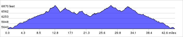
This ride starts in SE Albuquerque but goes up through Tijeras Canyon into the east mountains. The route winds all over and includes little-traveled roads, some steep climbs, and interesting scenery. Route planned by Lester Arakaki.
Distance: 45.3 miles, 3,237 ft. elevation gain.
Getting There: This ride begins at Smith's on Tramway, south of Central.
Roadway: Mostly 2-lane roads.
Options: You can start at the Library in Tijeras and shorten the ride by 14 miles.
Available Downloads
MAP CUE SHEET TCX COURSE
(Turn by turn directions)
GPX TRACK
(Breadcrumb trail)
GPX ROUTE
(Cuesheet waypoints)
Route on
RideWithGPS.com