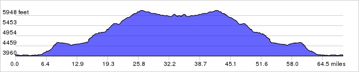
This ride is a loop that takes you into the mountains up the “Big Nasty” to return along the river. Note that some of the climb is very steep.
Note that outside of Moab, the only place to get food or water on this ride is at is at the Red Cliffs Lodge around mile 45.
Distance: 63 miles, 5,461 ft. elevation gain.
Getting There: This ride begins in Downtown Moab.
Roadway: Mostly 2-lane. There are a few rough spots at the top of the route in teh Mountains.
Options: You can get a shuttle from town to drop you off at the top. Check with local bike shops for more information.
- Also see Dead Horse Point, Arches National Park and Canyonlands North.
Available Downloads
MAP CUE SHEET TCX COURSE
(Turn by turn directions)
GPX TRACK
(Breadcrumb trail)
GPX ROUTE
(Cuesheet waypoints)
Route on
RideWithGPS.com