This ride is a terrific, scenic out and back ride in the Santa Fe National Forest to the edge of the Pecos Wilderness. Most of the route follows the Pecos River. You can now ride pavement all the way past Cowles to the end of pavement at Jack's Creek USFS campground and trailhead.
You can begin at the Pecos National Historical Park. Pay the $3.00 entry fee and park in the nice picnic area by the park headquarters and have a picnic on the return. Tour the old mission, ruins, and visitor center next to it.
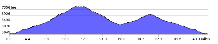
The Pecos Canyon begins wide as you ride through Pecos and past the fish hatchery and fields But the canyon quickly narrows as you follow the Pecos through the forest past rocky outcrops and cliffs. There are turnouts all along here for fishers. The first 12 miles or so only gains about 500 feet for about a 1% grade.
The first little climb is at Tres Lagunas where you pass the quaint compound with it's fishing ponds. You enter ponderosa forests. You pass numerous campgrounds and picnic grounds. At Terrero the road turns and you get your first hard 7% climb that isn't too long. The pavement narrows here to about a lane and a half for about 6 miles to Cowles. There is some rolling up and down hills to the intersection at Cowles. You're now in spruce and aspen forests. There is an occasional glimpse of Pennetente Peak above Santa Fe. Past Cowles the road becomes nice two lane road to Jack's Creek trailhead but is, well, brutal. Past the turn-off to Iron Creek the road really starts climbing. There are a couple of switchbacks below the campground that hit 13%, but it's not that far.
Catch your breath in the cool forest at the USFS Jack's Creek campground and take in the view. The return route is to retrace your route. Savor the downhill ride back to Pecos and the picnic area. Have lunch and take a hike through the ruins.
Be prepared for rain. The Pecos Wilderness is a lovely area to hike if you have the time. Mountain bikes are not allowed in National Forest wilderness areas in this region, although horses are.
Distance: 46.8 miles, 3,225 ft. elevation gain.Getting There: This ride begins at Pecos National Historical Park ($3.00 entry fee) about 25 miles east of Santa Fe. Take the I-25 exit 299 and go north about 2 miles to the park on NM63. Go to the visitor center first and pay then park at the picnic area.
Roadway: Mostly 2-lane with light traffic.
Note: There is a small grocery store at mile 16 and plenty of rest rooms at the campgrounds along the route.
Available Downloads
MAP CUE SHEET TCX COURSE
(Turn by turn directions)
GPX TRACK
(Breadcrumb trail)
GPX ROUTE
(Cuesheet waypoints)
Route on
RideWithGPS.com