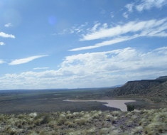
The Jemez Dam Ride is a pleasant open ride six miles north of US550 west of Bernaillo that has nice views of the nearby Jemez Mountains to the north and a distant view of the northern Sandia Mountains to the south. There is a picnic area at the Jemez Dam overlook with covered picnic tables. There are several options that include this ride to make it longer. The elevation is low and the terrain is open so start early to beat the heat and winds.
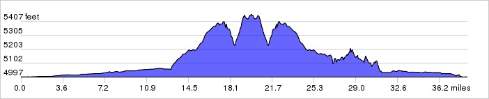
Distance: 38.6 miles, 1,057 ft. elevation gain.
Getting There: This ride begins at the Alameda Open Space.
Roadway: There is almost no traffic and the roadway is typically 2-lanes with no shoulder in OK condition.
| Available
Downloads |
|||||
| MAP | CUE SHEET | TCX
COURSE (Turn by turn directions) |
GPX
TRACK (Breadcrumb trail) |
GPX
ROUTE (Cuesheet waypoints) |
Route
on RideWithGPS.com |