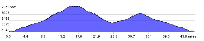
This ride starts in Albuquerque and heads up Tijeras Canyon into the east mountains. It takes you up and down through the mountains passing through the town of Tijeras three times. Nothing too steep and some fun descents.
Distance: 46.8 miles, 3,225 ft. elevation gain.Getting There: This ride begins at Smith's on Tramway, south of Central.
Roadway: Mostly 2-lane with light traffic.
Options: You can start at the Library in Tijeras and shorten the ride by 14 miles.
- See also Lester's East Side Ride.
Available Downloads
MAP CUE SHEET TCX COURSE
(Turn by turn directions)
GPX TRACK
(Breadcrumb trail)
GPX ROUTE
(Cuesheet waypoints)
Route on
RideWithGPS.com