Santa Fe Ski Area Climb

 
View West from SF Climb

View West From Overlook

The classic Santa Fe Ski Area Climb starts and ends at the de Vargas Mall on Paseo de Peralta. You climb through forests of ponderosa and aspen forests in the Santa Fe National Forest to the ski area on the Santa Fe National Forest Scenic Byway.

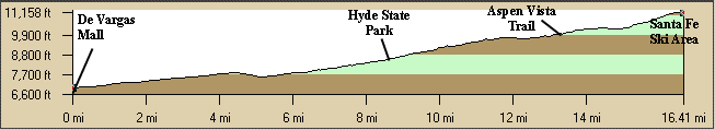
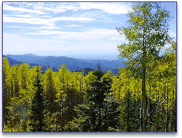
There are several terrific overlooks on the way up of the Jemez area to the west. Towards the top you pass the Aspen Vista trailhead which is a terrific mountain bike climb to the top of the mountain and ski area. This is mainly a long steady grind but there are a few steep stretches like at Hyde Park.

Take a locking cable so you can walk around the ski area. The ski lift may be running and you can get a lift to the top of the ski area. It is such a pretty area spend some time at the top. It's a terric descent. The elevation at the base of the ski area is 10,350' and the summit is12,053'.

Getting There: This ride starts and ends at the de Vargas Mall on Paseo de Peralta at N Guadalupe St. From I-25 take St. Francis or Cerillos Rd. north past their intersection on St. Francis and turn right (east) on Paseo de Peralta (at the round bank) to the mall. Follow signs to the Santa Fe Ski area.

Distance: 33 miles round trip, 4,200' Elevation Gain. There is about 300' of climbing on the return.

Roadway: It is paved in various states of maintenance. It is two laned without shoulders with light traffic.

Options: Start at Ft. Marcy Park or park along the ski area road just beyond Ft. Marcy.

Notes:

  • There is water at the ski area if it is open. There is water and snacks available at Hyde Park half way up.
  • There are Forest Service bathrooms at the ski area parking lot and at several recreation areas along the way open year-round.
  • The ski lifts may be running to the top or the whole area may be closed.
  • Santa Fe Ski Area Website.
  • Santa Fe National Forest Scenic Byway
  • Santa Fe National Forest (USFS) / Espanola Ranger District

    The Windsor Trailhead takes off from the ski area parking lot into the Pecos Wilderness area. There are great high-elevation hikes to Pecos Baldy, Lake Peak, etc., on the Skyline Trail.

  • There are also great mountain bike rides in the area. Check out guide books for the Aspen Vista trail, etc.

Santa Fe Ski Area CueSheet // 33 Miles, 4200' Elevation Gain.
Mileage Waypoint Leg Description

0

de Vargas Mall Ride east on Paseo de Peralta from the de Vargas Mall

.75

Masonic Lodge at Bishop's Lodge Rd. Turn left at the light onto 2-lane Bishop's Lodge Rd (Washington), ride north.

.9

Ski area Rd / Ft. Marcy Park Turn right at the traffic light and ride steeply up the road to the ski area. Stay on this road all the way to the ski area. The route follows the Little Teseque Creek up through the ponderosa and aspen groves. There are some interesting geological roadcuts.

8.5

Hyde Park Continue up the steep hill by the USFS campgrounds.

13.3

Aspen Vista Rd. On the right is a great introductory MTB climb up to the towers on the ridge. USFS outhouse.

 16.5

Santa Fe Ski Area Catch your breath and enjoy the view before returning the same route. Your are at 10,350'. Enjoy the descent! The top of the ski area is about 12,053' should you take a ski lift up.

33

de Vargas Mall  


Santa Fe Ski Area Climb Elevation Profile

Note the approximately 4,200 ft. elevation gain.

Elevation Profile