Santa Fe By-Pass Out and Back


The new Santa Fe Bypass and the reconstructed US285 north of Santa Fe now provide a reasonable way to ride from 
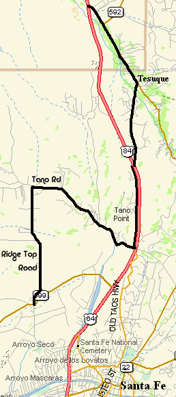
Santa Fe north and plenty of day ride opportunities. One of these day rides is the Santa Fe ByPass Out and Back.

This route is mainly out in the open with great views in all directions of the Sangre de Cristo and Jemez mountains.

This tour avoids taking the section of US285 that goes by the opera that has no frontage road by going through the village of Tesuque and Ridge Top and Tano Roads. See the cuesheet below.

Us the Old Taos Highway from the center of Santa Fe to connect with the frontage road along US285. The north end of Old Taos Highway is closed but bicycles can ride along it and a bike path to US285. This is a nice route.

Thanks to Dennis and Dede for developing this ride.

Getting There: This ride starts and ends at the Santa Fe Brewery off NM14 just north of the intersection with NM599, east of I-25.

Distance: 56 miles, 3,295' total elevation gain, about 1400' going, 1800' on the return.

Roadways: NM599 has a shoulder the whole way but watch out for glass and debris. The US285 frontage road has almost no traffic and shoulders but watch for glass. Ridge Top and Tano Roads are rural roads some with shoulders but light traffic.

Options: If you miss Ridge Top Road on the return, you can continue on Tano Road but it has a lot of hills.

Notes:

  • There are several convenience stores in Pojoaque.
  • The brewery serves lunch and of course, beer.
  • There's also a market store in the Tesuque Village.
 

NM599 / US285 Intersection


Santa Fe ByPass Out and Back CueSheet // 56 miles, 3200 Feet total elevation gain
Mileage Waypoint Description

0

Santa Fe Brewery Ride north and east out of the parking lot.

.3

NM14 Turn right (south) on NM14

1.0

NM14 / NM599 Turn right (west) at the traffic light on NM599. Steady climb.

13.7

Ridge Top Road Exit Exit right just before mile marker 13.

14.0

Ridge Top Road Turn left (north) at the stop sign onto Ridge Top Road. Goes under NM599. Nice hills

15.0

Tano Road Stop sign. Turn right (east) onto Tano Road.

15.7

Frontage Rd Tano Road curves left (north) and becomes the frontage road along the west side of NM599. Downhill

17.1

Stop sign Turn right (north) on CR73 and go under US285.

18.1

Tesuque Market Continue straight through the village of Tesuque.

20.1

US285 Stop sign. Go under US285

20.2

US285 Stop sign. Bend right (north) onto west frontage road.

22.1

4-way stop Continue straight on frontage road.

23.3

Stop Sign Continue straight past Camel Rock

24.8

3-way stop Continue straight on frontage road.

26.2

Stop sign Continue straight

27.7

Traffic light Turn right and cross US285. Continue to the convenience store. The east frontage road continues north.

28

Pojoaque Return by the same route.