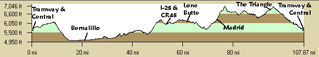
| Mileage |
Leg Description |
|
0
|
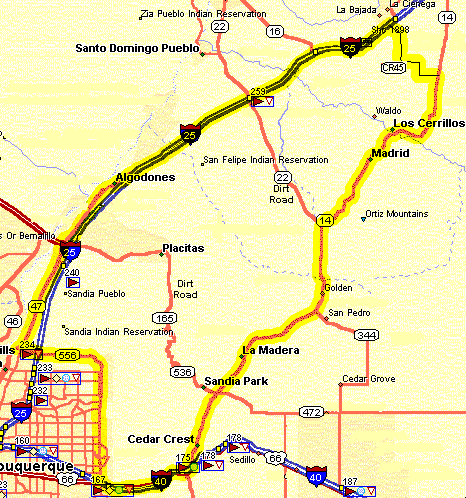
Four Hills Smiths. Take Tramway, NM556, north. There are plenty of places
to stop for food until I-25. |
|
4.4
|
Pass Montgomery. Continue north on Tramway. Tramway has nice smooth clean
shoulders from I-40 to I-25. Watch the area in front of the Sandia Casino just east of I-25. The shoulder is a
little confusing, do not get on the right side of right turning traffic. The last thing the people coming or going
to the casino are looking for is cyclists. |
|
13.5
|
Cross under I-25, still on Tramway. The gas station here is the last food
until Bernalillo. |
|
15
|
Turn right on NM313 to Bernalillo, signed. NM313 has no shoulders and crumbling
edges to Bernalillo with moderate traffic. |
|
23.4
|
NM44. Continue north on NM313. Several gas stations here. |
|
23.9
|
The Country Store on the right (east) - Food! A more pleasant section, rural
area with little traffic. |
|
29.7
|
Jct With NM315. Two Options:
1-Turn Right (E) on NM315, 0.4 miles to I-25. Cross over and ride North (left) on the shoulder to the Waldo Exit
267.
2-Continue North on NM313 to the stop sign at San Felipe. Continue below. |
|
33.3
|
Stop Sign at San Felipe: Turn right (east), ride 1/4 mile and cross over
I-25 where it dead ends. Carry your bike a few feet to I-25 and ride north on the shoulder. Both options are together
again.
Option: Turn left (west) to San Felipe pueblo stop sign. Turn right at the stop sign, ride to the San Felipe Casino.
This option avoids about 2.5 miles of interstate but is about 6.3 miles which adds about 4 miles. |
|
35.8
|
Exit 252: San Felipe Casino and gas Station - Food and bathrooms. At 253
begin new pavement, smooth. Hills. |
|
42.8
|
Exit 259 Cochiti Exit: NM22, gas station. NM22 west goes to Cochiti and Pena
Blanca. NM22 east is a rough dirt road, too bad, that goes to NM14. |
|
46.7
|
Exit 263: Bottom of Hill, Gallisteo River. Cross
over (east) the concrete barriers at their beginning to the frontage road.
There is no easy way since a fence is there and it is not designed with bicycles in mind. The barriers seperate
the frontage road (2-way) and I-25. These are the usual prefab concrete barriers with the headlight shades on top.
Once you pass the beginning you can't get over them due to the shades. The shoulder narrows uncomfortably in a
little bit with the 3 lanes of traffic up La Bajada Hill. A paved road goes 6 east miles to the Gallisteo Dam here. |
|
47.7
|
Exit 264: NM16: End of the frontage road again, back on the highway. The
highway is older here but the shoulder is adequate, not great. |
|
50.2
|
Exit 267 - Waldo Exit. Follow the frontage road almost to Bonanza Creek Road
(Santa Fe County Rd. 45) just before the Turquoise Trading Post. You pass an I-25 rest stop with bathrooms, water,
with an information center. Just before the rest area is the top of La Bajada Hill with vistas of the Sandias,
Sangre de Cristos, Cerillos Hills, Jemez Mountains, and Ortiz Mountains. The country road goes east here about
1/2 mile before it turns to dirt. It continues to Waldo and the town of Cerillos. |
|
53.8
|
Bonanza Creek Road (SF Country Rd. 45). Turn right (east). Follow this as
it winds south then uphill then onto Silver Hills Rd east until NM14. There are no other paved intersections until
NM14, just follow the pavement as it turns E, S, E, S, E. 6.8 miles. |
|
60.6
|
NM14: Turn right (south) all the way to I-40. There are several gas stations
and a cafe here. The Lone Butte store and Shell station is at the intersection. |
|
67.6
|
Turnoff to Cerrillos. Continue south on NM14. |
|
76.76
|
Madrid. Grocery store, resturants, coffee. Last food until the "Triangle",
16 miles. |
|
83.6
|
Pass NM344 - continue south on NM14. |
|
93.2
|
The "Triangle": Junction with Frost Road, NM14, and the Crest Road.
There is a grocery store and a convienence store. Continue south on NM14. |
|
98.6
|
Pass under I-40, junction at the Tijeras traffic light. This is now old RT66,
now nameed NM333. Continue west to Albuquerque. |
|
106.7
|
Pass under and over I-40 to the Four Hills traffic light. Smiths is in sight.
Turn left at Tramway and the cars! |