El Rito Loop
The scenic El Rito Loop in scenic northern New Mexico follows the Rio Chama, El Rito and the Rio Ojo Caliente. There are great views of the northern Jemez Mountains and the classic Cerro Pedernal (9,862') to the south in the Santa Fe National Forest. To the east you can see the Truchas Peaks and Santa Fe Baldy in the Sangre de Cristo Range. Being a loop this ride can start anywhere along the loop, e.g. in Abiquiu or Ojo Caliente.
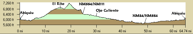
Distance: 62 miles.
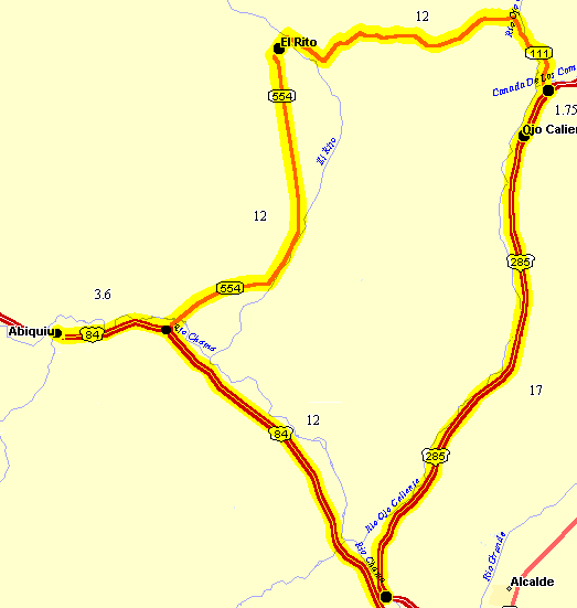
Getting There: North from Santa Fe to Espanola, north on US84 to Abiquiu. Optionally, it's 17 more miles north to Ojo Caliente.
Roadways: All paved. US285 has new pavement and some shoulders but some near Ojo Caliente are taken up completely by rumble strips. US285 has light but fast traffic. US84 has some shoulders. The roads near El Rito have little traffic.
Options:
- Echo Ampitheater is about 17 miles, each way, northwest of Abiquiu on NM84. This passes Abiquiu Lake and has some rolling hills.
Notes:
- Ojo Caliente Spa - Lodging, food, camping, and of course, hot springs in Ojo Caliente, NM.
- Abiquiu Inn - Lodging and food on US84 east of Abiquiu.
- Echo Ampitheater - On Carson National Forest land 17 miles NW from Abiquiu on NM84.
El Rito Loop CueSheet // 62 Miles
Mileage Waypoint Leg Description 0
Abiquiu Travel east on NM84 3.6
NM84 Turn north (left) on NM554 towards El Rito 15.6
El Rito Continue north then curving east on NM554/NM111. 27.7
US285 Turn right (south) on US285 towards Espanola. 29.4
Ojo Caliente Continue south on US285 46.3
Jct NM84 & US285 Turn right (north) on NM84 toward Abiquiu. 58.3
NM554 Continue west on NM84. 62
Abiquiu