El Malpais National Mounument
Out-and-Back Rides
 |
|
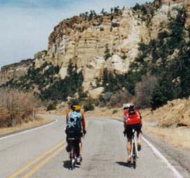
Riding North on South NM117
|
The El Malpais National Monument Out and Back Rides are terrific spring and fall rides. These are delightful
rides that go through red-rock terrain, wildflowers, and pinon and ponderosa pine forests. The routes are pretty
flat and open. These are fairly moderate tours with no big hills.
There is much evidence of past volcanic action southwest of Grants. The lava covers an area of 60 by 35 miles.
The roads follow the edge of the twisted black lava deposits which stretch westwards to the horizon. The lava beds
were produced from eruptions of several volcanoes up until about 800 years ago. They have since been gradually
covered by scattered trees and bushes.. There are new El Malpais
National Monument Visitor Centers along both NM53 and NM117 that have interesting information and water. It
can get really, really hot in the summer so take plenty of water, snacks, and your camera. Boy can it be windy
in the spring, too.
Getting There: The El Malpais National Monument Rides can be reached on NM117 and
NM53, both near Grants.
Distances: Both rides are pretty flat.
- NM53: 49 miles, 1,250' elevation gain.
- NM117: 60 miles, 1,130' elevation gain
Options:
See the nearby El Morro National Monument Ride.
 |
|
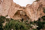
La Ventana Natural Arch
on NM117
|
Notes: It can get really hot in the summer, take plenty of water and sunscreen. The only water on the route
is available at the visitor centers.
El Malpais National Monument Out and Back Ride via NM53
The El Malpais National Monument via NM53 begins and ends at the Grant's government center on the main
road in Grants near the museum. Head south on NM53 through ponderosa and pinon pine forests with nice views. [top]
Getting There: From Grants get off I-40 at Exit 81 on NM53. Park at the Grant's government center on
the main road in Grants near the museum.
Distance: 49 miles, 1250 feet total elevation gain, 1140 ft. going, ~110 ft. on the way out.
Roads: NM53 has light trafficand nice shoulders all the way to the Visitor's center. The nice shoulders
stop at the information center but the road beyond is fine. 3 miles (each way) Construction in 2001 may have improved
the pavement which was in pretty bad shape.
Option: From the Visitor's center, continue up the hill to the continental divide past the entrance to
Bandera Ice caves. There are a few views along the way. 370 feet elevation gain.
| El Malpais Out and Back CueSheet // 49 Miles, 1,250' |
| Mileage |
Waypoint |
Description |
|
0
|
Grants Center |
Ride west on the main road 1.5 miles past the McDonalds, cross over I-40,
and proceed south on NM53. NM53 has fairly new pavement and has nice, wide smooth, clean shoulders (no rumble strip)
for the 23 miles to the El Malpais National Monument Information center. The route gradually rises 1140 feet in
elevation. Enjoy. The Acoma Trailhead is at 17.7 miles.NM53 has light traffic. |
|
24.5
|
El Malpais National Monument Information Center |
Stop for a break, check out the information at the new Information center.
Return by the same route. Gradual downhill, 100 ft elevation gain somewhere on the return.
Option: Continue
up the hill to the continental divide past the entrance to Bandera Ice caves. There are a few views along the way.
370 feet elevation gain. The nice shoulders stop at the information center but the road beyond is fine. 3 miles
(each way) |
|
49
|
Grants |
|
|
|
El Malpais NM53 Route Map
 |
|
US NPS Map
|
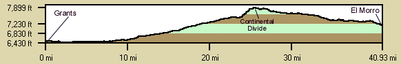
El Malpais National Mounment Ride via NM53 Elevation Profile
Both the El Malpais and El Morro elevation profiles are shown. Both are fairly flat. The El Malpais route ends
at the 24.5 mile point.
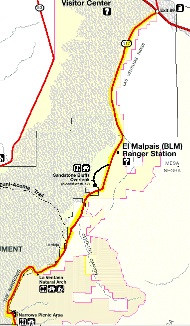
El Malpais National Monument Out and Back Tour via NM117
There is much evidence of past volcanic action west of Grants. The lava covers an area of 60 by 35 miles, the
road follows the edge of the twisted black lava deposits which stretch westwards to the horizon. The lava beds
were produced from eruptions of several volcanoes up until about 800 years ago. They have since been gradually
covered by scattered trees and bushes. [top]
Getting There: Begin east of Grants at Exit 89 on I-40 at the NM117 junction. There is a Stuckey's at the
intersection where you might park and have lunch on the return.
Distance: 60 Miles round trip to the lava falls, 1,130' elevaton gain: 930' gain in, 200' gain on return.
Roads: NM117 has very light traffic and no shoulders but the pavement is in fine shape all the way to
the Lava Falls pullout.
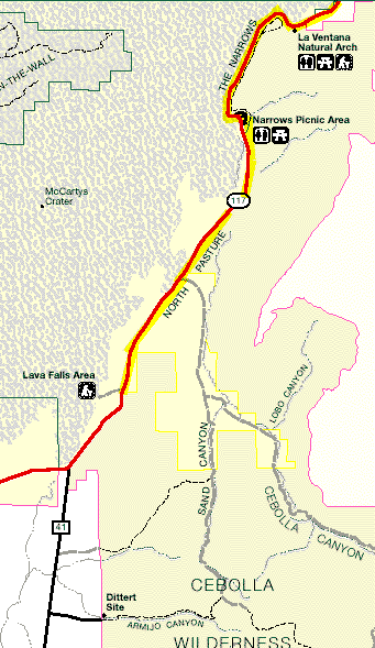
Dittert Site Option (via dirt roads): From the Lava Falls continue riding south on NM117 1.6 miles to 41.
Turn left (south) on 41, ride 3.7 miles to the Dittert Site turnoff on the left. Turn left and ride 1.5 miles on
a dirt road to the Dittert site which has a Kiva and several excavated rooms. There are about 3500
achaeological sites in the 4 WSA's in the area. Return to NM117 and Grants by the same route. BLM Brochure.
Notes: There is a Ranger Station 8 miles south on NM117 that has water.
| El Malpais NM117 Out and Back CueSheet // 60 Milles, 1130' Elevation gain. |
| Mileage |
Waypoint |
Description |
|
0
|
Grants, NM117 & I-40 |
Ride south on NM117. NM117 has reasonable surface and light traffic. Stay
on NM117 all the way south to the Lava Falls Area. |
|
8.3
|
El Malpais Ranger Station |
Shared by BLM, NPS and Forest Service. Ice Water. |
|
9
|
Sandstone Bluffs Overlook Turnoff |
Sandstone Bluffs Overlook Picnic area. About 3/4 Mile off the highway. Panorama
of the lava fields. |
|
15.3
|
Zuni-Acoma Trail |
East end of a 7.5 mile prehistoric trail crossing the lava fields. |
|
18
|
La Ventana Natural Arch |
Neat arch just to the left of the highway. The largest in New Mexico. Continue
south through the "Narrows" whic are lava flows right up the the base of 500' sandstone cliffs. "La
Ventana" means "the window" in Spanish. |
|
22
|
Narrows Picnic Area |
Narrows Picnic Area on the east side of the road. |
|
31
|
Lava Falls |
Lava Falls Areas on the west side of the road. |
| |
Lava Falls Area |
Turn around here. Follow the same route back. |
|
61
|
I-40 |
Starting point. |
| |
Dittert Site |
Dittert Site Option (via
dirt roads): From the Lava Falls continue riding south on NM117 1.6 miles to 41. Turn left (south) on 41, ride
3.7 miles to the Dittert Site turnoff on the left. Turn left and ride 1.5 miles on dirt road to the Dittert site
which has a Kiva and several excavated rooms. (there are about 3500 achaeological sites in the 4 WSA's in the area).
Return to NM117 and Grants by the same route. |
|
|
El Malpais NM117 Route Map
Northern Portion
 |
Continuation South
US NPS Maps |