The first thing to do is to get the excellent Albuquerque Bike Map by calling 505-768-2526 or www.cabq.gov/bike or email bikemap@cabq.gov.
A goal of these routes is to try to cross Albuquerque with the simplest routes to minimize confusion. Also, these routes are the nicest possible. However, there are some convoluted sections so use the city bike map.
The state highway department has dictated that there is no bicycling on interstates within urban areas. This is a good idea since there are no shoulders in a lot of areas. Travel on interstates outside of urban areas are allowed.
The following are
suggested routes, they are not official - this is what you would get if
you are out of state and ask
for advice. They are not perfect.
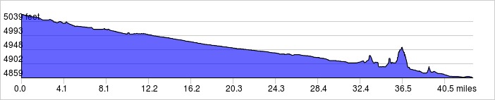
This route starts in
Bernalillo and goes south along the Rio Grande. The route ends in
Los Lunas. You can also use the New Mexico Rail Runner to
transport you and your bike from as far north as Santa Fe to as far south
as Belen.
Distance: 43.2 miles, 355 ft. elevation loss.
Roadway: Mostly bike trails, bike lanes and 2-lane roads.
Options: You can reverse the route to go from south to north.
| Available
Downloads |
|||||
| MAP | CUE SHEET | TCX
COURSE (Turn by turn directions) |
GPX
TRACK (Breadcrumb trail) |
GPX
ROUTE (Cuesheet waypoints) |
Route
on RideWithGPS.com |
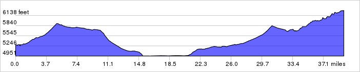
This route starts at the
Route 66 Casino and goes through Old Town, Downtown, the University and
east to Tijeras.
Distance: 39.6 miles, 2,308 ft. elevation gain.
Roadway: Mostly bike trails, bike lanes and 2-lane roads.
Options: You can reverse the route to go from east to west.
| Available
Downloads |
|||||
| MAP | CUE SHEET | TCX
COURSE (Turn by turn directions) |
GPX
TRACK (Breadcrumb trail) |
GPX
ROUTE (Cuesheet waypoints) |
Route
on RideWithGPS.com |