 |
|
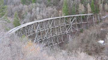
Old Railroad Trestle Near Cloudcroft |
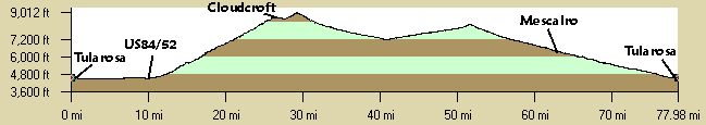
The steady climb (~4,135', 6%) from the junction of US82 and US54 climbs east from the Tularosa Basin into Ponderosa forests through canyons lined with sedimentary rocky cliffs. The convienence store at the 2-mile mark is the last chance before serious climbing begins. The only highway tunnel in Southern New Mexico is at the 7.3 mile mark on the climb up to Cloudcroft. A parking area just west (downhill) of the tunnel affords a spectacular view of Fresnal Canyon which has some prehistorical sites, White Sands, and the Tularosa Basin. High Rolls at about 8 miles (half way!) has a gas station/store. At 15.5 miles, just before Cloudcroft, is another pull-off area where you can stop and look at the spectacular railroad trestle spanning the Mexican Canyon. There are hiking and mountain biking trails in this area, see the Rails-to-Trails links below. Just as you enter Cloudcroft at 16 miles, there is a nice picnic ground and bathrooms uphill to the right.
The route continues straight through (east) Cloudcroft downhill to the well-marked turn on NM244 to Mescalareo. After the left turn on NM244 there is a moderate climb through Ponderosa forests. There are a couple of USFS campgounds along the way. Then there is a nice long downhill following a drainage where the canyon starts widening out. Then there is an unmarked left turn at "Elk Canyon" and a uphill climb again through open forests. After topping out there is a nice downhill all the way to US70. Turn left going west on US70 using the nice shoulders. Descend through Mescalaro with White Sands off in the distance. By now the terrain is wide open and you have views in all directions. Enter Tularosa and ride through town to the starting location.
 |
|
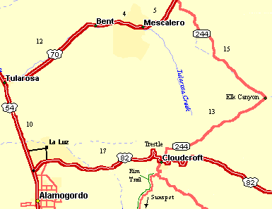
Loop Map |
Distance: 77 Miles (2-days), ~6000' elevation gain (mostly in Day 1).
Day 1: Climb from Tularosa to Cloudcroft , 26 miles, about 5,000' of climbing. Options?
Day 2: Cloudcroft to Tularosa via Mescalaro, 51 miles, largely downhill (maybe ~1,000' of climbing). Follow NM244 east from Cloudcroft to US70 west to Tularosa.
Roadway: Mainly two lane roads with light traffic on weekends. The steep 16 miles of NM82 from Alamogordo to Cloudcroft is 2-lane highway with several passing lanes. There are stretches with guard rails close to the edge making it rather claustrophobic but on weekend mornings traffic should be fairly light. The pavement is in decent shape. The 10 miles from Tularosa to NM82 is divided 4-lanes with shoulders, pretty flat, moderate fast traffic, and a fair number of semi's. There is a tunnel at about the 6-mile mark that is not too long, maybe 100 yards but no lights. US70 is 4-laned with nice shoulders all the way to Tularosa.
Options: Once in Cloudcroft, there are beautiful rides in the Sacramento Mountains.
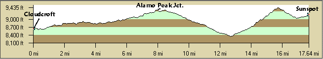
- The well-marked 17.5 mile ride (each way) through the ponderosa forest to the interesting Sunspot Solar Observatory near Sacramento Peak has about a total 3,100' elevation gain (both ways). Being out-and-back you don't have to go the whole way. There is a short 9% stretch. Take NM130 out of Cloudcroft 2 miles to Scenic Byway NM6563 for about a total 17.5 miles south from Cloudcroft to the Sunspot Observatory. The well-marked turn is at about the 14 mile marker. The observatory is about a mile west of NM6563. The highway gives great views of the Tularosa Basin and the dunes of the White Sands National Monument and Sierra Blanca. Allot some time for the self-guided tour. There is a interesting visitor's center. There is more downhill on the return back to Cloudcroft. The pavement is excellent, has almost no traffic, and is well marked. On its own this is a terrific ride but combined with the climb from Alamogordo it is a challenge.
- The 14-mile mountain bike Rim Trail begins at the Lincoln National Forest Slide Campground about 2-1/2 miles south of Cloudcroft on NM6563 and ends at the Alamo Peak road, paralleling the Sacramento Mountain's rim and NM6563. You then can ride the trail or the pavement back to Cloudcroft. The Rim Trail crosses several forest roads that can be ridden east to the pavement. It's rocky. There is another access point along NM6563 just south of Slide Campground.
- Riding south from Tularosa at about 7 miles is a traffic light and a signed left turn to La Luz. Take this road about 2-1/2 miles through this pretty town to the stop sign and dead end at La Luz Rd. Turn right (south) for about 1 mile to US54).
Notes: There are lots to see and do in Alamogordo and Cloudcroft. Read Bicycling America's National Parks: Arizona and New Mexico by Sarah Bennett Alley for detailed descriptions of ride options around Cloudcroft and Alamogordo.
- Alamogordo: Large city with all the usual motels, air base, fast food, zoo, Wal-Mart, Space History
Museum, etc. ...
- Tombaugh Imax Space Theatre and Space History Museum in Alamogordo - Great views from above the city.
- , south west of Alamogordo - White gypsum dunes.
- Cloudcroft: Small touristy ski town with a grocery store, gas station, cafes, and motels.
- Apache Point Observatory - Turnoff is left on the Sunspot Solar Observatory road.
- Cloudcroft Rails to Trails.
- Cloudcroft Rail Trail Website - Photos of Mexican Canyon Trestle along US82 and other information.
- Cloudcroft website for information about lodging, etc. Cloudcroft has gas stations, grocery store, Ranger Station, ...
- The Lodge at Cloudcroft - SAG'd your golf clubs? The turnoff is 1/2 mile into town the 1/2 south uphill.
- Sunspot Solar Observatory Website - There are guided (2pm summer weekends) and self-guided tours, take your camera. There is a great visitor center, plan some time to visit, 505-434-7000.
- Lincoln National Forest Sacramento Ranger District.
- Three Rivers Petroglyph BLM Recreation Site - 21,000 petroglyphs, between Tularosa and Carizozo. A must see on the way if you have the time.
- Tularosa: There are a couple of motels (no name brands), B&B, Tastee Freeze, and Subway, and gas stations. Lots of pistachio orchards.
- Valley of Fires Recreation Area BLM site 4 miles west of Carrizozo on US380 has a visitor center and a campground in extensive, very young, lava flows. There is a $3 entry fee.
- White Sands National Monument - The dunes drive is a flat 8-mile (each way) ride out and back from the visitor's center on US70. There are several trails that you can hike, picnic areas, a boardwalk trail, and the dune trail at the end of the road. Take a lock. The last 2 miles or so of the paved road may be covered by packed gymsum with soft spots. There is water at the visitor's center but none on the loop. Take your camera.