Big Bend Roundup


Chisos Mountains - Emory Peak Trail - Eric Russell Photo

Chisos Mountains - Emory Peak Trail

The Big Bend Roundup is a 6-day ride in the Texas Big Bend area that has been presented by a NMTS ride leader. Ride through Big Bend National Park in the southern most part of Texas. Big Bend NP is the largest park in Texas. From an elevation of less than 2,000 feet along the Rio Grande to nearly 8,000 feet in the Chisos Mountains, Big Bend includes massive canyons, vast desert expanses, and the entire Chisos Mountain range. The road up to Mt. Locke, near Ft. Davis, known as the steepest road in Texas, is the location of McDonald Observatory of the University of Texas. There are tours and a visitor center. Spend the night in Marfa looking for the Marfa Mystery Lights (ha ha). Check out the Ft. Davis National Historic Site, a well preserved late 1800's Army post. The ride from Big Bend to Presidio is loaded with very interesting scenery. Terlingua, east of Lajita, is a ghost town where cinnabar was once mined. This ride should be done in the spring or fall due to the high summer temperatures. The Big Bend National Park web site has temperature averages, daily temperatures, and campground and lodge status. There is quite a bit of elevation gain though at lower elevations. The park is busy during spring break when there is a good temperature range but is pretty deserted otherwise. The in-park campgrounds are often filled during spring break.

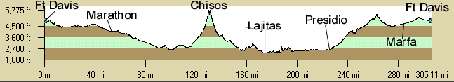
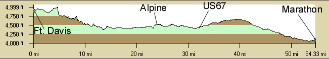
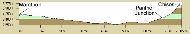
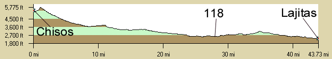
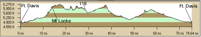
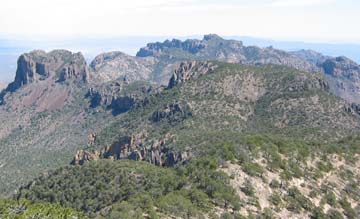
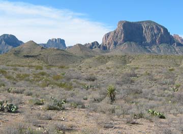
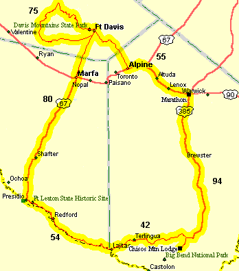
Texas labels their rural highways Farm to Market (FM) roads, Ranch to Market (RM) roads, or Ranch Roads (RR).

Ft. Davis Loop

The Ft. Davis Loop is a scenic, fairly hard, 75 miles, 7,000' elevation gain ride. The ride goes through volcanic mountains and grasslands. You may see antelope or javalena along the way. If the entire loop is too much, the 16-mile out and back from Ft. Davis to the McDonald Observatory Visitor Center is the best part of the loop. The observatory has guided and self guided tours of the observatories. The guided tour is about a hour and a half so take a locking cable. After a steep 200' climb, there is a lobby at the new HET where you can view the telescope. Ft. Davis is not too big but there is a lot to see. The Ft. Davis National Historical Site has restored military quarters from the 1800's. The Ft. Davis State Park has a nice campground and the park's Indian Lodge is really nice at a reasonable price and has a nice restaurant. All the roads are in good condition and it is designated a Scenic Loop. There are shoulders along TX166 until the turn to Valentine, then the pavement narrows but there is almost no traffic.

Big Bend Roundup Route

The route between the various towns on the Big Bend Roundup loop has few places to pick up food and water so be prepared and stock up when you pass through a town.

The route from Ft. Davis to Marathon opens up and is pretty flat and uneventful. There are a few small hills west of Alpine. Marathon is pretty limited but there is the historic Gage Hotel. There are a couple of gas stations at the turn to Big Bend.

The route from Marathon to the Chisos Basin is pretty barren. The Big Bend Headquarters has the first water until the basin. The Chisos Basin is easily the most scenic part of the loop. Schedule an extra day or two to hike or sight see at the the basin. Good trails are the Lost Mine Trail, the Window Trail, and the Emory Pass Trail. There is a campground but it doesn't have showers and it is first come first served. There is a group campground that does take reservations. The Chisos Basin Mountain Lodge is very nice and reasonably priced and there is a restaurant and a camp store there. The only gasoline is at the station at Panther Junction. The steep climb up to the basin is only 6 miles but is very scenic. Actually, the steepest section on the road is outbound up to the Lost Mine trailhead. A nice side trip is to Castolon and the walk along the Rio Grande at San Elena Canyon. Big Bend is busy during the Texas schools spring break in March but drops off fast as soon as it is over. The NPS Big Bend website will have more information and has a Daily Report which includes weather and campground usage.

Chihuahuan Desert - Eric Russell Photo

Chihuahuan Desert - Big Bend NP

The ride down from the Chisos Basin to Lajitas passes through the Chihuahuan Desert. Study Butte west of the park has the first facilities, some gas stations and motels. Take the turn south about 2 miles west of Study Butte to follow the Rio Grande. You ride through Terlingua. This section along the Rio Grande is surprisingly picturesque. There are dramatic cliffs on the Mexican side of the Rio Grande. The town of Lajitas has camping, stores, and some pricey lodging.

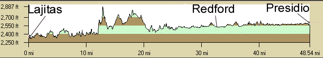
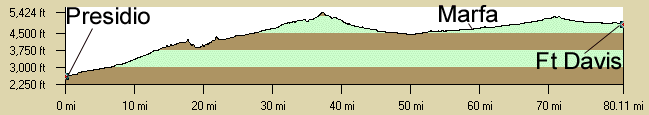
About half way from Lajitas to Presidio there is about a 15 percent mile long climb that is pretty dramatic with great views to the south over the Rio Grande. There is a nice rest area (no water) at the top. There is a lot of climbing since there are a lot of dry wash crossings that dip down then climb back up. Once to Redford, the road flattens to Presidio but is less interesting. Nowadays, there are lots of signs informing you that crossing into Mexico is ok but it is illegal to reenter anywhere but at an official entry point like Presidio. Take your paperwork if you want to cross into Mexico at Presidio and be allowed to return to the US. North of Presidio you pass the Shafter ghost town.

The stretch from Presidio to Ft. Davis gradually climbs from desert to grassland. Off in the distance to the west is the Chinati Mountains. There are a number of moderate long climbs along the way. It's pretty boring, a good day to sag. Marfa has a pretty impressive courthouse in the center of town. The observatories on the Davis Mountains give away the fact that you're getting close to Ft. Davis.

On the long drive home to New Mexico, stop in Carlsbad and visit the Carlsbad Caverns National Park or the Living Desert Zoo State Park in Carlsbad.

Thanks to Art Pinson for developing this ride.

Loop Map

Big Bend Loop

Getting There: Ft. Davis is 38 miles south of I-10 in the south west corner of Texas east of El Paso. It can also be reached by US90 from the west. See the NPS Getting There Map for mileages. From Albuquerque, taking US285 through Carlsbad, Pecos, Tx, to Ft. Davis is one possible route.
Albuquerque to the Chisos Mtns Lodge is about 610 miles.
Albuquerque to Ft. Davis, Tx is about 480 miles.

Roadways: All the pavement is in good condition, shoulders in some areas, and light traffic for nearly the whole route.

Distance: 396 miles, 5 Riding Days.

Options:

  • There are many options in Big Bend National Park. There are lots of hikes. There are also river trips.
  • Ride up to McDonald Observatory near Ft. Davis and take a tour of the observatory. about only a 1.5 mile / 600' climb.
  • See also Palo Duro Canyon.
  • On the way stop at Carlsbad Caverns National Park or the Living Desert Zoo in Carlsbad. No, you can't ride your bike in the cave but there is almost no traffic in the park.

Notes:


Big Bend Roundup CueSheet // 6 Days 396 Miles
Mileage Description
Day 1 - 75 Miles Davis Mountain Loop. via TX166 - TX118 - TX17. Ft. Davis to Ft. Davis. Passes the turnoff to Mt. Locke and McDonald Observatory. Stay in Ft. Davis.
Day 2 - 55 Miles Ft. Davis - Alpine (23 miles) - Marathon, situated in a basin of great geologic interest. via TX118 - US67 - US90.
Day 3 - 94 Miles Marathon to Big Bend Park Chisos Basin. Chisos Mountain Lodge. via US385 - TX118 - TX170. Visit the Persimmon Visitor and the Panther Junction Visitor Center. Some interesting pull-offs in the park. There is a gas station just past the Panther Junction Visitor center, no store. There is a store and restaurant at the Chisos Basin.
Day 4 - 42 Miles Big Bend Chisos Basin to Lajitas on the Rio Grande. via TX170 through Study Butte and Terlingua. Lots of climbing.
Day 5 - 54 Miles Lajitas to Presidio along El Camino del Rio. Lots of climbing. Those who wish can arrive at Presidio early enough to visit Ojinaga, Mexico. vi TX170. Road flattens at Redford.
Day 6 - 80 Miles US67 Presidio to Ft. Davis via Marfa, site of the Marfa Mystery Lights (they only come out at night).
Total: 396 Miles  

Big Bend Roundup Elevation Profiles

Note that the elevation scale on the left is not the same on all profiles. The climb to the Chisos Basin looks pretty hard but it is only a moderate climb and not that far and is by far the most scenic part of the ride.

Big Bend Loop
Does not include the Ft Davis Loop
Big Bend Loop
Day 1:
Ft Davis to Marathon
Day 2: Marathon to Chisos Marathon to Chisos Basin
Day 3:
Chisos to Lajitas
Chisos to Lajitas
Day 4:
Lajitas to Presidio
(Jagged lines are bogus artifacts of the software)
Lajitas to Presidio
Day 5:
Presidio to Ft Davis
Ft. Davis Loop
~7,000' Elevation Gain