The theme of this ride is to connect many of the Chavez-named places in Albuquerque. The ride starts out on the west and south sides of the city, with a food stop in Old Town at about the half way point. After the break, the ride continues into the southeast and northeast heights to pick up more Chavez-named places.
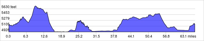
Distance: 67.3 miles, 2.372 ft. elevation gain.Getting There: This ride starts at the Taylor Ranch Library parking lot.
Roadway: Two lane roads, bike lanes, shoulders and bike paths.
Available Downloads
MAP CUE SHEET TCX COURSE
(Turn by turn directions)
GPX TRACK
(Breadcrumb trail)
GPX ROUTE
(Cuesheet waypoints)
Route on
RideWithGPS.com