This is not an
official map of the Santa Fe Century. This map is provided for NMTS
members who might not know the route so that they can ride all or part
of the route.
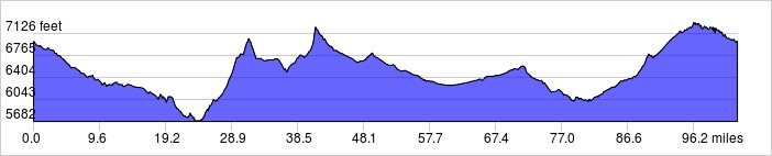
There are long isolated stretches on the route where there is no water
or supplies available. It is advisable to have support. The route is
mainly out in the open so riders are vulnerable to the wind and summer
thunderstorms. Be prepared. The temperatures get pretty high in the
summer and it can snow in Santa Fe in November so this is a spring/fall
ride.
Heartbreak Hill is pretty steep. In the spring watch for sand on the
downhill sections from winter snow sand trucks until rains wash it off.
The hill and big rollers on US285 from the NM41/US285 junction are not
as steep as Heartbreak Hill but really go on.
There is a grocery store in Madrid a convenience gas stations in Lone
Butte (on NM14 near I-25) and El Dorado (US285 near I-25).
Distance: 102.7 miles, 5,151 ft. elevation gain.
Getting There: Starts at the Christus St. Vincent hospital on St Michaels Drive in Santa Fe.
Roadway: All paved in good condition, some shoulders, light traffic except near Santa Fe.
| Available
Downloads |
|||||
| MAP | CUE SHEET | TCX
COURSE (Turn by turn directions) |
GPX
TRACK (Breadcrumb trail) |
GPX
ROUTE (Cuesheet waypoints) |
Route
on RideWithGPS.com |