The Sandia
Crest Climb (10,640 ft.) is a scenic, challenging climb (4,880'
from Tijeras) to the highest point on the Sandia Mountains and quite an
accomplishment for all cyclists. The descent is not to be missed. It has
tight turns on descent and can be considerably colder than town. This is
a great ride to practice your descent technique. Once on NM536 you are
climbing mostly through a heavily forested road with very low traffic.
This is a lovely summer evening ride in the lengthening shadows, with
cooler temperatures, and with almost no traffic. NM14 and NM536 (Sandia
Crest Road) are parts of the Turquoise Trail and are a National Scenic
Byway.
The climb goes through several vegetation zones and interesting geologic
features. The route goes through ponderosa, aspen, and spruce forests.
The aspens turn vibrant yellows and orange in the fall. The locust trees
bloom in the spring along the lower elevations. Most of the year
wildflowers line the highway.
You enter the Cibola National Forest just past Tinkertown.
The Sandias are relatively young, geologically. Road cuts display
sandstone and limestone layers broken in different directions hinting at
the forces at work raising the range. As you pedal past Doc Long, the
Great Unconformity is visible in the road cut across from Doc Long. The
rocks above the line are 250 million years old, those below are 1,450
million years old. The unconformity is a 1.2 billion year gap that has
been eroded away then younger rocks deposited above.
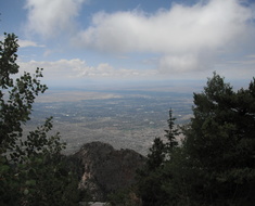
At the summit on the observation deck, you are standing on fossil-laden
Pennsylvanian limestone. There is a parking lot at the crest where there
is a USFS visitor center and snack bar and gift shop. There are normally
quite a few people at the crest but it is not congested. You might want
to bring a light locking cable to be able to walk to the observation
platform or south along the Crest Trail. There is a superb view of all
of Albuquerque, Mt. Taylor, Ladron Peak, and the Jemez Mountains on the
west.
The Sandia Crest Climb is a popular cycling route and you will normally
see other cyclists on the road or meet them at the top.
A popular summer evening ride is to start at the Triangle and ride up
through the lengthening shadows to twilight and turn around before the
downhill at the ski area.
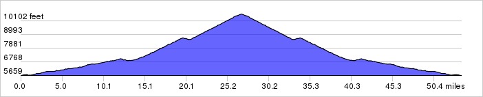
Distance: 53.7 miles, 5,887 ft. elevation gain.
Getting There: Starts at Smith's on Tramway just south of Central.
Roadway: There is light traffic from the Triangle to the Crest. There are shoulders about half of the way up. The road surface is in good shape, newly resurfaced. Watch for dirt on the tight corners. The upper road to the crest was built originally in 1923, paved in 1966, and rebuilt in the early 80's with the Ellis and 10-K trailheads and passing lanes and repaved in 2005 so it is in good condition at this time.
| Available
Downloads |
|||||
| MAP | CUE SHEET | TCX
COURSE (Turn by turn directions) |
GPX
TRACK (Breadcrumb trail) |
GPX
ROUTE (Cuesheet waypoints) |
Route
on RideWithGPS.com |